Category:Geology of the Kimberley
Jump to navigation
Jump to search
geology of the Kimberley region of Australia _Geological_Map.png) | |||||
| Upload media | |||||
| Instance of |
| ||||
|---|---|---|---|---|---|
| |||||
Subcategories
This category has the following 3 subcategories, out of 3 total.
B
- Bungle Bungle Range (62 F)
H
- Halls Creek Orogeny (1 F)
- Hooper Orogeny (9 F)
Media in category "Geology of the Kimberley"
The following 16 files are in this category, out of 16 total.
-
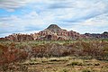 .00 0848 Kimberley, Western Australia.jpg 3,900 × 2,600; 9.88 MB
-
 Endless Stations 70 - So Hot, So Dry, So Bright.jpg 4,201 × 3,000; 13.84 MB
-
 Geology of Kimberley (Western Australia) Alternative Models (a).png 1,866 × 2,997; 1.06 MB
-
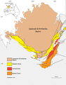
 Geology of Kimberley (Western Australia) Geological Map.png 1,515 × 1,939; 1.05 MB
-
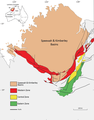
 Geology of Kimberley (Western Australia) Overview Map.png 937 × 870; 188 KB
-
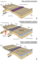
 Geology of Kimberley (Western Australia) Tectonic Evolution (a).png 1,866 × 999; 336 KB
-
 Geology of Kimberley (Western Australia) Tectonic Evolution (b).png 1,866 × 999; 451 KB
-
 Geology of Kimberley (Western Australia) Tectonic Evolution (c).png 1,866 × 1,001; 386 KB
-
 Geology of Kimberley (Western Australia) Tectonic Evolution (d).png 1,866 × 1,001; 441 KB
-
 Geology of Kimberley (Western Australia) Tectonic Evolution (e).png 1,866 × 1,001; 362 KB
-
 Geomap edited.png 1,515 × 1,939; 865 KB
-
 Geomap edited1.png 1,515 × 1,939; 865 KB
-
 KC 2d 1.png 2,193 × 1,172; 292 KB
-
 Kimberley EMBM1.png 1,866 × 999; 305 KB
-
 Kimberley EMBM2.png 1,866 × 999; 440 KB
-
 Timespace plot1.png 2,481 × 2,133; 520 KB


_Alternative_Models_(a).png)
_Overview_Map.png)
_Tectonic_Evolution_(a).png)
_Tectonic_Evolution_(b).png)
_Tectonic_Evolution_(c).png)
_Tectonic_Evolution_(d).png)
_Tectonic_Evolution_(e).png)


