Category:Geomatics
Salti al navigilo
Salti al serĉilo
academic discipline as a merge from geodesy and geoinformatics. geomatics concerned with the collection, distribution, storage, analysis, processing, presentation of geographic data or geographic information | |||||
| Alŝuti plurmedion | |||||
| Prononco-registraĵo | |||||
|---|---|---|---|---|---|
| Estas | |||||
| Subaro de |
| ||||
| Nomita laŭ |
| ||||
| Havas parton |
| ||||
| Anstataŭiĝas per |
| ||||
| Alia ol | |||||
| |||||
Subkategorioj
Ĉi tiu kategorio havas la 4 jenajn subkategoriojn, el 4 entute.
G
R
Dosieroj en kategorio “Geomatics”
La jenaj 12 dosieroj estas en ĉi tiu kategorio, el 12 entute.
-
 AI1.png 719 × 507; 60 KB
-
 AI2.png 699 × 531; 146 KB
-
 AI3.png 540 × 334; 48 KB
-
 Constellation-SDI.png 229 × 92; 15 KB
-
 Dron geomática.jpg 4 608 × 3 072; 1,71 MB
-
 Esquema explicativo de una IDE.gif 3 509 × 2 488; 5,88 MB
-
 Field-Map birdie.jpg 2 592 × 2 768; 2,76 MB
-
 LOGO-GEOMATICA-ES.png 2 404 × 1 240; 42 KB
-
 Precise Level Benchmark, Singapore.jpg 3 024 × 4 032; 5,43 MB
-
 Random sampling method for training and testing dataset.png 1 639 × 1 373; 4,5 MB
-
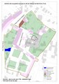 Schéma de l'occupation tardive de l'Abbaye de Saint-Evre (Toul).pdf 1 754 × 2 481; 389 KB
-
 بعض مكونات الجيوماتكس والعلاقة بينها.jpg 632 × 876; 121 KB


