Category:Remote sensing
Jump to navigation
Jump to search
日本語: リモートセンシング
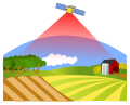
· English: Remote sensing is the acquisition of information about an object or phenomenon without making physical contact with the object and thus in contrast to on site observation.
acquisition of information about an object or phenomenon without making physical contact with the object, especially the Earth  | |||||
| Upload media | |||||
| Pronunciation audio | |||||
|---|---|---|---|---|---|
| Instance of | |||||
| Subclass of |
| ||||
| Different from | |||||
| |||||
Subcategories
This category has the following 21 subcategories, out of 21 total.
Media in category "Remote sensing"
The following 167 files are in this category, out of 167 total.
-
 14inch RCOpticalSystems2.jpg 183 × 131; 4 KB
-
 2009 RSC.JPG 1,190 × 842; 69 KB
-
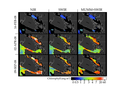
 978-3-642-01546-5 26 Fig1 HTML.webp 590 × 229; 24 KB
-
-

-

-
 AirSAR-instrument-on-aircraft.jpg 1,670 × 2,528; 386 KB
-
 AphelionApplication22.jpg 300 × 300; 36 KB
-
 AphelionApplication4.jpg 300 × 300; 43 KB
-

-

-
-

-

-
-

-
-
-
-

-
-

-

-
-
-
-
-
-
-

-

-
-
-
-
-
 Archaeological use of EM spectrum.svg 1,050 × 743; 101 KB
-
 AVIRIS Los Alamos.png 614 × 570; 304 KB
-
-
 Bacteria, sea slicks and satellite remote sensing.webp 1,050 × 664; 36 KB
-
 Baie Atka Sentinel 2 cc843 14 02 2019.png 900 × 600; 562 KB
-
 Beam spreading Doppler Radar.jpg 9,000 × 3,000; 2.23 MB
-
 Bhaskara-1.jpg 357 × 300; 14 KB
-
 Białowieża Forest in false colour composition.jpg 6,433 × 7,954; 45.97 MB
-
 Blackbody emission.svg 512 × 427; 20 KB
-
 BrownPulseReflection.jpg 1,464 × 842; 72 KB
-
 Bush information system data survey.jpg 4,608 × 3,456; 3.49 MB
-
 Classification Schema.svg 1,050 × 743; 33 KB
-
 Column Measurements Representation.png 2,250 × 3,000; 1.56 MB
-
 Death-valley-sar.jpg 1,200 × 2,501; 668 KB
-
 Decreasing radiometric resolution from L7 15m panchromatic.svg 1,052 × 744; 2.94 MB
-
 Decreasing spatial resolution from l715m panchromatic.svg 1,052 × 744; 3.79 MB
-
 Development of mangrove remote sensing since 1956.jpg 2,013 × 1,400; 293 KB
-
 Diurnal thermal variation.svg 1,050 × 740; 41 KB
-
 Drone and Quarry.jpg 4,000 × 3,000; 2.67 MB
-
 Earthquake remote sensing.svg 998 × 985; 314 KB
-
 EM power and atmosphere interaction diagram.svg 880 × 600; 11 KB
-
 EM Spectrum Properties reflected.svg 675 × 400; 158 KB
-
 Empiracle Remote Sensing Analysis.svg 1,052 × 744; 777 KB
-
 Example Plot of Umkehr curve..tif 1,700 × 2,200; 10 KB
-
 FIS Logo.jpg 624 × 282; 49 KB
-

-
 FormationProcessesAndArchaeologicalDetection.svg 1,052 × 1,488; 2.06 MB
-
 Gaofen images of Xichang forest fire.jpg 2,096 × 1,229; 745 KB
-
 Gaofen-3 radar images.jpg 2,125 × 1,164; 808 KB
-
 Geoarcut Logo Gris.jpg 388 × 228; 23 KB
-
 Global SRTM Bathymetry map.png 6,600 × 3,000; 4.63 MB
-
 Global tree canopy map NASA.jpg 7,920 × 3,472; 3.67 MB
-
 GNSS-R system diagram.svg 318 × 276; 31 KB
-
 GRACE Amazon hydrology.jpg 800 × 1,155; 142 KB
-
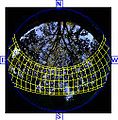 Hemiphoto stream1.jpg 250 × 254; 20 KB
-
 Hemiphoto stream2.jpg 250 × 254; 14 KB
-
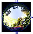
 Hemispherical photo1.jpg 2,861 × 2,835; 2.7 MB
-
 Hemispherical photography canopy manual rich 1989.pdf 1,275 × 1,650, 92 pages; 1.23 MB
-
 Hemispherical photography image manual rich 1989.pdf 1,275 × 1,650, 88 pages; 1.81 MB
-
 Hemispherical photography laicalc manual 1995.pdf 1,275 × 1,650, 13 pages; 55 KB
-
 HPS-MODIS-543RGB-2002-4 glacier-inventory.png 4,460 × 12,351; 4.5 MB
-
 Hyperspectral And Frame Camera Detection Arrays.svg 1,050 × 743; 210 KB
-
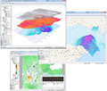
 IDRISI GIS.jpg 1,920 × 1,200; 837 KB
-
 Ilwis38a.png 600 × 508; 330 KB
-

-
 Interspect UAS photogrammetry.jpg 4,252 × 1,242; 6.84 MB
-
 Interspect UAV B 3.1.png 2,076 × 1,924; 3.28 MB
-
 JAXA ANA GOBLEU mockup (closeup).jpg 5,568 × 3,712; 4.23 MB
-
 JAXA ANA GOBLEU mockup.jpg 3,361 × 5,042; 3.69 MB
-
 Kamera Positionen.jpg 300 × 161; 11 KB
-
 Land cover map of Nepal using Landsat 30 m (2010) data.jpg 2,400 × 1,200; 2.07 MB
-
 Land-12-00885-g008.png 2,534 × 2,550; 2.34 MB
-
 Landsat 2 with Data Striping.gif 399 × 399; 85 KB
-
 Main india night Jan 06-21-28 01.gif 368 × 229; 104 KB
-
 Mixed pixel.svg 1,050 × 743; 32 KB
-
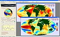
 Monitoring processes in the ocean from remote sensing.jpg 1,950 × 1,463; 189 KB
-
 Mono multi and hyperspectral.svg 744 × 818; 244 KB
-
 Mono, Multi and Hyperspectral Cube and corresponding Spectral Signatures modified.svg 4,000 × 2,500; 177 KB
-
-
 MS and HS scanning systems.svg 765 × 990; 194 KB
-
 Mtm-05277e 3d.png 1,274 × 972; 522 KB
-
 Multi and Hyper spectral imaging systems.svg 765 × 990; 196 KB
-
 Multi Hyper-spectral Image feature space.svg 1,050 × 743; 86 KB
-
 MultispectralComparedToHyperspectral.jpg 360 × 361; 117 KB
-
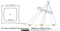 Oblique camera distortions.svg 920 × 481; 26 KB
-
 PatternRecognitionProcess.png 800 × 544; 120 KB
-
 PGR Paulson07 big.jpg 810 × 985; 111 KB
-
 Phailin CTT 11 Oct 2013.jpg 1,024 × 1,024; 310 KB
-
 Photon wavelength.svg 744 × 1,053; 36 KB
-
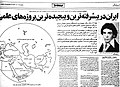 Pirooz Naderi.jpg 991 × 715; 260 KB
-
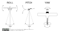 Pitch Roll and Yaw.svg 1,050 × 743; 60 KB
-
 Pixel By Pixel Footprint For Imagery.svg 932 × 756; 19 KB
-
 Pixelresampling.svg 1,012 × 418; 130 KB
-
 Plant Biology Experiment in Archaeology.svg 1,050 × 740; 1.17 MB
-

-
 Push broom scanner visualization.gif 892 × 557; 1.59 MB
-
 Radiometric Resolution.svg 1,052 × 744; 5.02 MB
-
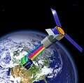
 RapidEye Satellites Artist Impression.jpg 1,450 × 1,050; 96 KB
-
 Rapideye-mockupp.jpg 852 × 631; 97 KB
-
 Real Estate Assistance (remote-1).jpeg 2,560 × 2,048; 638 KB
-
 Reflectancia de vegetación.svg 1,838 × 612; 43 KB
-
 Relationship pixel size and mixed pixels.svg 740 × 1,050; 808 KB
-
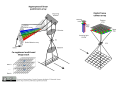
 Remote Sensing Energy Interaction Schematic.svg 1,050 × 740; 396 KB
-
 Remote sensing forest structure - random volume over ground model.png 3,564 × 1,034; 985 KB
-
 Remote Sensing Illustration-ar.png 1,302 × 1,217; 471 KB
-
 Remote Sensing Illustration.jpg 1,302 × 1,217; 148 KB
-
 Remote sensing of coastal and marine environment.webp 3,804 × 2,539; 1.22 MB
-
 Remote sensing system diagram.svg 840 × 520; 8 KB
-
 Remote Sensing tackling geological problem.png 641 × 561; 23 KB
-
 Remote Sensing Wavelength Info.png 600 × 312; 20 KB
-
 Remotesensing-09-01063-ag.png 1,351 × 989; 909 KB
-
 Remotesensing-11-01502-v2.pdf 1,239 × 1,752, 23 pages; 5.23 MB
-
 Resolution bumping, Bitterroot Mountains.png 1,834 × 865; 1,017 KB
-
 River valleys in the Białowieża Forest.jpg 2,471 × 3,352; 6.91 MB
-
 Satellite imaging.svg 840 × 677; 87 KB
-
 Schematic Drawing of Remote Sensing.png 758 × 625; 58 KB
-
 Schematic Drawing of RS.png 757 × 624; 60 KB
-
 Sentinel-2 and derived products from the Romanian EO Data Cube (2).pdf 706 × 1,164; 15.08 MB
-
 Sentinel-2 and derived products from the Romanian EO Data Cube.pdf 706 × 927; 7.97 MB
-
 Sfm.jpg 220 × 164; 14 KB
-
 Shortwave energy through atmosphere.svg 1,050 × 740; 29 KB
-
 Singur Landsat 8 OLI 20171102 cc431.png 744 × 600; 1.1 MB
-
 Solar spectrum cs.svg 800 × 600; 47 KB
-
 Solar spectrum en.svg 800 × 600; 49 KB
-
 Solar spectrum es.svg 800 × 600; 47 KB
-
 Solar spectrum it.svg 800 × 600; 49 KB
-
 Space saves society logo.png 350 × 311; 422 KB
-
 Spatial resolution comparison for archaeological features.svg 1,052 × 744; 32.68 MB
-
 Specific phytoplankton absorption spectra.xcf 805 × 492; 96 KB
-

-
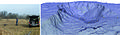
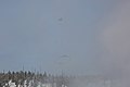 Subsurface survey helicopter flies near the Upper Geyser Basin (30975326012).jpg 5,272 × 3,515; 10.23 MB
-
 Subsurface survey helicopter flies near the Upper Geyser Basin (30975329132).jpg 3,538 × 5,307; 11.2 MB
-
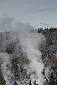
 Subsurface survey helicopter flies over Biscuit Basin (31081878206).jpg 4,376 × 2,917; 8.74 MB
-
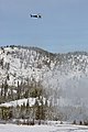 Subsurface survey helicopter flies over Biscuit Basin (31081980716).jpg 3,596 × 5,394; 14.03 MB
-
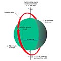 Sunsynchronous orbit en.jpg 2,600 × 2,600; 608 KB
-
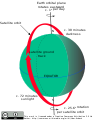 Sunsynchronous orbit.svg 502 × 657; 40 KB
-
 TacSat-3 Model Earth Background.jpg 620 × 616; 106 KB
-
 TacSat3 testing.jpg 234 × 351; 13 KB
-
 Tacsat3 theater reconnaissance.png 2,048 × 1,548; 2.12 MB
-
 TacSat3Bus.png 372 × 278; 167 KB
-
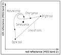 Tasseled Cap Transformation for bright and dark soil.jpg 783 × 708; 55 KB
-

-
 TOC Components as shown in Google Earth Engine.jpg 800 × 702; 76 KB
-

-
 TS by The sea.jpg 3,968 × 2,976; 3.75 MB
-
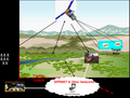
 UAV land sensing or monitoring.svg 1,354 × 1,385; 201 KB
-
 Ukraine 2016-12-07 Sentinel-2A L1 EO Browser Sentinel hub Custom script.jpg 1,727 × 966; 1.07 MB
-

-
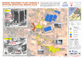 UNOSAT Gaza Sewage Plant Pre Post Map v12 Highres.png 3,306 × 2,340; 7.23 MB
-
 UNOSAT GazaStrip Damage Review 19Feb09 v3 Lowres.png 2,481 × 3,509; 4.54 MB
-
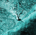 Waterways in Charleston, South Carolina.png 537 × 516; 768 KB
-
 Світло-тіньове супутникове зображення мікрорельєфу місцевості.jpg 1,130 × 839; 714 KB


_to_a_sensor_after_interaction_with_the_Earth.svg)


.jpg)


_data.jpg)


.jpeg)


.jpg)
.jpg)
.jpg)
.jpg)


_(1992)_(19123462804).jpg)
_(1992)_(19123469314).jpg)
_(1992)_(19125037023).jpg)
_(1992)_(19125046833).jpg)
_(1992)_(19125083003).jpg)
_(1992)_(19125086673).jpg)
_(1992)_(19125102963).jpg)
_(1992)_(19125186133).jpg)
_(1992)_(19557901668).jpg)
_(1992)_(19557906710).jpg)
_(1992)_(19557921580).jpg)
_(1992)_(19558103438).jpg)
_(1992)_(19558111558).jpg)
_(1992)_(19559356389).jpg)
_(1992)_(19559525319).jpg)
_(1992)_(19559529179).jpg)
_(1992)_(19719762796).jpg)
_(1992)_(19719766716).jpg)
_(1992)_(19719800996).jpg)
_(1992)_(19719842266).jpg)
_(1992)_(19719954596).jpg)
_(1992)_(19738931442).jpg)
_(1992)_(19746006545).jpg)
_(1992)_(19750638421).jpg)
_(1992)_(19750658981).jpg)
_(1992)_(19750799491).jpg)
_approach_for_collecting_remote_sensing.jpg)
.jpg)