Category:Geoinformatics
Jump to navigation
Jump to search
application of information science methods in geography, cartography, and geosciences | |||||
| Upload media | |||||
| Pronunciation audio | |||||
|---|---|---|---|---|---|
| Instance of | |||||
| Subclass of |
| ||||
| Part of |
| ||||
| Named after |
| ||||
| Different from | |||||
| Partially coincident with |
| ||||
| |||||
Media in category "Geoinformatics"
The following 13 files are in this category, out of 13 total.
-
 DTM DSM.png 833 × 469; 154 KB
-
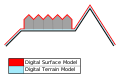 DTM DSM.svg 1,003 × 652; 8 KB
-
 Geo-info-voorziening.PNG 711 × 471; 185 KB
-
 Gruppenbild SIK-GIS 2018-11-29.jpg 2,215 × 1,513; 874 KB
-
 Imago3D.jpg 1,088 × 557; 272 KB
-
 Mayor olabiyitan-1500212820193.jpg 1,080 × 1,080; 806 KB
-
 ORNL History (31561223717).jpg 3,150 × 1,500; 3.98 MB
-
 Overlap.svg 285 × 117; 3 KB
-
 Praesidenten SIK-GIS 2018-11-29.jpg 2,846 × 1,928; 1.83 MB
-
 Przykład kwerendy w oprogramowaniu QGIS.jpg 1,924 × 1,026; 361 KB
-
 Remote Sensing Illustration-ar.png 1,302 × 1,217; 471 KB
-
 Remote Sensing Illustration.jpg 1,302 × 1,217; 148 KB
-
 SemanticWFS FC of OS.png 1,633 × 921; 1.1 MB


.jpg)


