Category:George Cather farmstead (Webster County, Nebraska)
Jump to navigation
Jump to search
| Object location | | View all coordinates using: OpenStreetMap |
|---|
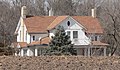
historic farm in Bladen, Nebraska  | |||||
| Upload media | |||||
| Instance of | |||||
|---|---|---|---|---|---|
| Location | Bladen, Webster County, Nebraska | ||||
| Heritage designation |
| ||||
| Inception |
| ||||
 | |||||
Media in category "George Cather farmstead (Webster County, Nebraska)"
The following 10 files are in this category, out of 10 total.
-
 Geo. Cather Farmstead address.JPG 619 × 173; 42 KB
-
 Geo. Cather Farmstead barn 1.JPG 2,560 × 998; 1.14 MB
-
 Geo. Cather Farmstead barn and bins.JPG 2,160 × 1,091; 970 KB
-
 Geo. Cather Farmstead barn and equipment.JPG 2,560 × 1,020; 1.14 MB
-
 Geo. Cather Farmstead bins S of road.JPG 2,560 × 1,011; 1.16 MB
-
 Geo. Cather Farmstead from ESE 1.JPG 2,484 × 1,041; 1.09 MB
-
 Geo. Cather Farmstead from ESE 2.JPG 2,560 × 931; 1.04 MB
-
 Geo. Cather Farmstead house from ESE 1.JPG 1,796 × 1,051; 815 KB
-
 Geo. Cather Farmstead house from SE 1.JPG 1,694 × 1,051; 782 KB
-
 Geo. Cather Farmstead sign.JPG 2,560 × 1,628; 1.62 MB


