Category:Ghantaï temple Khajuraho
Jump to navigation
Jump to search
| Object location | | View all coordinates using: OpenStreetMap |
|---|
building in India  | |||||
| Upload media | |||||
| Instance of | |||||
|---|---|---|---|---|---|
| Part of | |||||
| Location | Khajuraho, Chhatarpur district, Sagar division, Madhya Pradesh, India | ||||
| Heritage designation |
| ||||
 | |||||
Media in category "Ghantaï temple Khajuraho"
The following 11 files are in this category, out of 11 total.
-
 01022 Ghantai temple, Khajuraho Madhya Pradesh 01.jpg 3,024 × 4,032; 5.7 MB
-
 01022 Ghantai temple, Khajuraho Madhya Pradesh 02.jpg 2,938 × 3,918; 4.23 MB
-
 01022 Ghantai temple, Khajuraho Madhya Pradesh 03.jpg 2,930 × 3,908; 5.53 MB
-
 01022 Ghantai temple, Khajuraho Madhya Pradesh 04.jpg 2,928 × 3,904; 6.41 MB
-
 01022 Ghantai temple, Khajuraho Madhya Pradesh 05.jpg 2,703 × 3,606; 5.18 MB
-
 01022 Ghantai temple, Khajuraho Madhya Pradesh 06.jpg 3,024 × 4,032; 4.73 MB
-
 01022 Ghantai temple, Khajuraho Madhya Pradesh 07.jpg 3,024 × 4,032; 4.74 MB
-
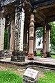
 A ruin, pillars at Khajuraho, India.jpg 3,456 × 2,304; 8.09 MB
-
 Ghantai Temple Khajuraho.jpg 1,206 × 847; 526 KB
-
 Ghantai Temple.jpg 2,676 × 4,026; 4.79 MB
-
 Khajuraho ruins of Ganthai Jain temple, Madhya Pradesh, 1875 photo.jpg 474 × 712; 140 KB


