Category:Godalming
Jump to navigation
Jump to search
town in the Borough of Waverley in Surrey, England  | |||||
| Upload media | |||||
| Instance of | |||||
|---|---|---|---|---|---|
| Location | |||||
| Population |
| ||||
| Area |
| ||||
| official website | |||||
 | |||||
Deutsch: Godalming ist eine Kleinstadt in England mit ungefähr 20.000 Einwohnern. Sie befindet sich in der südenglischen Grafschaft Surrey und ist Verwaltungssitz des Waverley Borough.
English: Godalming ( south of Guildford. It is built on the banks of the River Wey and is a prosperous part of the London commuter belt. Godalming shares a three-way twinning arrangement with the towns of Joigny in France and Mayen in Germany. Friendship links are in place with the state of Georgia in the United States and the city of Moscow in Russia. James Oglethorpe, of Godalming and educated at Charterhouse School, was the founder of the colony of Georgia.
Español: Godalming es una ciudad en el distrito de Waverley en el condado de Surrey, Inglaterra, 7 kilómetros al sur de Guildford. Se encuentra a orillas del río Wey y es una próspera ciudad dentro del área metropolitana de Londres. Godalming comparte un triple hermanamiento con las ciudades de Joigny (Francia) y Mayen (Alemania). También hay vínculos de amistad entre el estado de Georgia y la ciudad de Moscú (Rusia). James Oglethorpe, de Godalming y educado en la Escuela Charterhouse, fue el fundador de la colonia de Georgia.
ქართული: გოდელმინგი არის ქალაქი სურეის საგრაფოში, ინგლისში, რომელიც გილდფორდიდან შვიდი კილომეტრის მოშორებით მდებარეობს. იგი დამეგობრებულია სხვა ქვეყნების ქალაქებთან: ჟოინისთან (საფრანგეთი) და მაიენთან (გერმანია). ასევე იგი დამეგობრულია ჯორჯიის შტატთან (აშშ) და მოსკოვთან (რუსეთი).
Lietuvių: Godlmingas – miestas pietų Anglijoje, 7 km nuo Gilfordo. Geležinkelio stotis. Veikia Charterhouse kolegija, karaliaus Edvardo mokykla, stovi bažnyčia, XIX a. rotušė.
Nederlands: Godalming is een plaats in het bestuurlijke gebied Waverley, in het Engelse graafschap Surrey. De plaats telt 21.103 inwoners.
Português: Godalming é uma cidade do distrito de Waverley, condado de Surrey, Inglaterra, situada a 7 km a sul de Guildford, nas margens do Rio Wey.
Română: Godalming este un oraş în comitatul Surrey, regiunea South East, Anglia. Oraşul se află în districtul Waverley a cărui reşedinţă este.
Subcategories
This category has the following 14 subcategories, out of 14 total.
Media in category "Godalming"
The following 200 files are in this category, out of 749 total.
(previous page) (next page)-
 "Surrey Place" on Mill Lane - geograph.org.uk - 3639379.jpg 800 × 600; 97 KB
-
 11, Church St - geograph.org.uk - 3448009.jpg 640 × 430; 67 KB
-
 14-18 Ockford Road, Godalming - geograph.org.uk - 4036611.jpg 3,638 × 2,720; 1.36 MB
-
 1663 - geograph.org.uk - 3028518.jpg 4,288 × 3,216; 3.57 MB
-

-
 2016, a year on Geograph (Day 182) - geograph.org.uk - 5017427.jpg 640 × 480; 65 KB
-
 2016, a year on Geograph (Day 196) - geograph.org.uk - 5037326.jpg 640 × 480; 78 KB
-
 2016, a year on Geograph (Day 291) - geograph.org.uk - 5160774.jpg 640 × 480; 103 KB
-
 2016, a year on Geograph (Day 315) - geograph.org.uk - 5188651.jpg 640 × 480; 53 KB
-
 2016, a year on Geograph (Day 316) - geograph.org.uk - 5190242.jpg 640 × 480; 58 KB
-
 2016, a year on Geograph (Day 319) - geograph.org.uk - 5193593.jpg 640 × 480; 59 KB
-
 2016, a year on Geograph (Day 320) - geograph.org.uk - 5198569.jpg 640 × 480; 41 KB
-
 2016, a year on Geograph (Day 321) - geograph.org.uk - 5198572.jpg 640 × 480; 44 KB
-
 2016, a year on Geograph (Day 322) - geograph.org.uk - 5198573.jpg 640 × 480; 59 KB
-
 2016, a year on Geograph (Day 323) - geograph.org.uk - 5198576.jpg 640 × 480; 46 KB
-
 2016, a year on Geograph (Day 328) - geograph.org.uk - 5205808.jpg 640 × 480; 50 KB
-
 2016, a year on Geograph (Day 329) - geograph.org.uk - 5205813.jpg 640 × 480; 44 KB
-
 2016, a year on Geograph (Day 333) - geograph.org.uk - 5209833.jpg 640 × 480; 57 KB
-
 2016, a year on Geograph (Day 335) - geograph.org.uk - 5213505.jpg 640 × 480; 49 KB
-
 2016, a year on Geograph (Day 336) - geograph.org.uk - 5213516.jpg 640 × 480; 60 KB
-
 2016, a year on Geograph (Day 337) - geograph.org.uk - 5213524.jpg 480 × 640; 38 KB
-
 2016, a year on Geograph (Day 341) - geograph.org.uk - 5221089.jpg 640 × 480; 40 KB
-
 2016, a year on Geograph (Day 344) - geograph.org.uk - 5221102.jpg 640 × 480; 111 KB
-
 59, High St - geograph.org.uk - 3453775.jpg 640 × 430; 70 KB
-
 85 Brighton Road, Crownpits - geograph.org.uk - 4012261.jpg 2,884 × 2,160; 1,019 KB
-
 A boar's head at the King's Arms - geograph.org.uk - 5100862.jpg 768 × 1,024; 157 KB
-
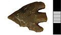 A Bronze Age barbed and tanged arrowhead, Godalming.jpg 855 × 496; 32 KB
-

-
 A canine presence in Carlos Street - geograph.org.uk - 1605773.jpg 480 × 640; 63 KB
-
 A dull autumn day in Croft Road - geograph.org.uk - 1605703.jpg 640 × 480; 41 KB
-
 A3100 - geograph.org.uk - 3439793.jpg 640 × 430; 86 KB
-
 A3100 - geograph.org.uk - 3453839.jpg 640 × 430; 48 KB
-
 A3100, Flambard Way - geograph.org.uk - 3453833.jpg 640 × 430; 54 KB
-
 A3100, Guildford Road - geograph.org.uk - 4635212.jpg 2,000 × 1,333; 2.76 MB
-
 Aaron's Hill, Godalming - geograph.org.uk - 4700618.jpg 2,000 × 1,333; 2.82 MB
-
 Above Catteshall Lock - geograph.org.uk - 2050626.jpg 2,560 × 1,920; 1.8 MB
-
 Allotments on north bank of Hell's Ditch - geograph.org.uk - 5723826.jpg 3,873 × 2,769; 3.31 MB
-

-
 Almshouse Meadow, Farncombe - geograph.org.uk - 5746656.jpg 3,888 × 2,592; 2.24 MB
-

-

-

-
 Anchor Beer Garden, Godalming - geograph.org.uk - 2050516.jpg 2,560 × 1,920; 1.76 MB
-
 Angel Court, Godalming - geograph.org.uk - 4036677.jpg 4,320 × 3,240; 4.72 MB
-

-

-
-

-

-
-

-

-

-

-

-

-

-
 Ash Court - geograph.org.uk - 1603537.jpg 640 × 480; 88 KB
-
 Autumn in Catteshall Lane - geograph.org.uk - 1603552.jpg 480 × 640; 79 KB
-
 Bandstand and parish church, Godalming, Surrey.jpg 2,507 × 1,880; 1.13 MB
-
 Bandstand in the Park - geograph.org.uk - 5796573.jpg 3,455 × 2,411; 2.69 MB
-

-
 Barnardos and Cook - geograph.org.uk - 4036689.jpg 2,165 × 2,882; 1.05 MB
-
 Barngate House - geograph.org.uk - 3453905.jpg 640 × 430; 97 KB
-
 Bel and the Dragon, Godalming - geograph.org.uk - 4036694.jpg 3,776 × 2,826; 1.85 MB
-
 Bell-opening, Godalming church - geograph.org.uk - 5101902.jpg 748 × 1,024; 218 KB
-
 Bend in Brighton Road - geograph.org.uk - 1605687.jpg 640 × 480; 106 KB
-
 Bend in Catteshall Lane - geograph.org.uk - 1603573.jpg 640 × 480; 56 KB
-
 Bend in Flambard Way - geograph.org.uk - 1602431.jpg 640 × 480; 91 KB
-
 Between the lines in the High Street - geograph.org.uk - 1604495.jpg 480 × 640; 93 KB
-
 Boarden bridge, Godalming - geograph.org.uk - 1980716.jpg 640 × 425; 194 KB
-
 Boardwalk by the River Wey in Godalming - geograph.org.uk - 4036576.jpg 4,320 × 3,240; 5.13 MB
-
 Boat houses at Catteshall - geograph.org.uk - 3919370.jpg 2,736 × 3,648; 4.75 MB
-

-
 Boots Opticians and Vision Express - geograph.org.uk - 4036684.jpg 4,320 × 3,240; 4.7 MB
-
 Borough Road Bridge - geograph.org.uk - 2892421.jpg 4,288 × 3,216; 3.68 MB
-
 Borough Road Bridge - geograph.org.uk - 3447896.jpg 640 × 430; 116 KB
-
 Borough Road Bridge - geograph.org.uk - 3447898.jpg 640 × 430; 111 KB
-
 Borough Road looking north - geograph.org.uk - 3639315.jpg 800 × 600; 169 KB
-
 Borough Road Railway Bridge - geograph.org.uk - 2892468.jpg 4,288 × 3,216; 3.65 MB
-
 Bourne Rd - geograph.org.uk - 5210791.jpg 640 × 426; 62 KB
-
 Bourne Rd - geograph.org.uk - 5216580.jpg 640 × 426; 57 KB
-
 Bowling Green in Phillips Park - geograph.org.uk - 5796578.jpg 3,888 × 2,592; 3.45 MB
-
 Bracket Fungi - geograph.org.uk - 3028745.jpg 3,216 × 4,288; 3.39 MB
-
 Brick-built houses in Brighton Road, Godalming - geograph.org.uk - 5100690.jpg 1,024 × 809; 256 KB
-
 Bridge House in Flambard Way - geograph.org.uk - 1602410.jpg 640 × 453; 54 KB
-

-
-
 Bridge over the Ock - geograph.org.uk - 4036595.jpg 4,320 × 3,240; 5.2 MB
-
 Bridge over the River Wey - geograph.org.uk - 4280861.jpg 640 × 427; 136 KB
-
 Bridge over the River Wey Navigation - geograph.org.uk - 1870861.jpg 800 × 600; 115 KB
-
 Bridge over the Wey in Godalming - geograph.org.uk - 4036582.jpg 4,320 × 3,240; 5.03 MB
-
 Bridge Road, Godalming - geograph.org.uk - 4639403.jpg 2,000 × 1,333; 2.38 MB
-
 Bridge Road, Godalming, view north - geograph.org.uk - 3493706.jpg 1,024 × 806; 146 KB
-
 Bridge Street in late November - geograph.org.uk - 1602328.jpg 480 × 640; 77 KB
-
-
 Bridge Street, Godalming - geograph.org.uk - 2286036.jpg 2,560 × 1,920; 1.95 MB
-
 Bridleway - geograph.org.uk - 3453980.jpg 640 × 430; 95 KB
-
 Brighton Road - geograph.org.uk - 1373898.jpg 640 × 480; 121 KB
-
 Brighton Road, Crownpits - geograph.org.uk - 1373914.jpg 640 × 480; 116 KB
-
 British Red Cross Shop - geograph.org.uk - 4036692.jpg 4,320 × 3,240; 2.43 MB
-
 Broad Water Lake - geograph.org.uk - 6231600.jpg 4,032 × 3,024; 3.85 MB
-
 Brook Cottage, Godalming - geograph.org.uk - 4036591.jpg 2,208 × 1,651; 1.05 MB
-
 Building behind Godalming Museum - geograph.org.uk - 4280849.jpg 640 × 427; 75 KB
-
 Bus in Flambard Way - geograph.org.uk - 1605666.jpg 640 × 480; 50 KB
-

-
 Bus shelter in Woolsack Way - geograph.org.uk - 1603503.jpg 640 × 480; 64 KB
-
 Busbridge - geograph.org.uk - 5092505.jpg 4,000 × 2,666; 7.67 MB
-
 Busbridge and Hambledon church office - geograph.org.uk - 3052690.jpg 640 × 480; 135 KB
-
 Busbridge Lane - geograph.org.uk - 2299098.jpg 800 × 600; 130 KB
-

-

-

-

-

-

-

-
 Busbridge, The end of Hambledon Road - geograph.org.uk - 6162787.jpg 5,861 × 3,907; 7.52 MB
-
 Butts Lane - geograph.org.uk - 1606024.jpg 480 × 640; 95 KB
-
 By Catteshall Lock - geograph.org.uk - 1377167.jpg 640 × 480; 95 KB
-
 Cafe at the Golf Course - geograph.org.uk - 5746627.jpg 640 × 420; 78 KB
-
 Café closed in the High Street - geograph.org.uk - 1603027.jpg 480 × 640; 60 KB
-
 Café Nero in the High Street - geograph.org.uk - 1604136.jpg 480 × 640; 81 KB
-
 Canada Geese on the Lammas Lands - geograph.org.uk - 3447878.jpg 640 × 430; 115 KB
-
 Canada Geese on the Wey - geograph.org.uk - 3447865.jpg 640 × 430; 111 KB
-
 Canal boats, River Wey Navigation - geograph.org.uk - 4635921.jpg 2,000 × 1,333; 2.77 MB
-
 Canal boats, River Wey Navigation - geograph.org.uk - 4636904.jpg 2,000 × 1,333; 3.28 MB
-
 Canal boats, River Wey Navigation - geograph.org.uk - 4639062.jpg 2,000 × 1,333; 2.68 MB
-
-
 Car park off Catteshall Lane - geograph.org.uk - 3453894.jpg 640 × 430; 54 KB
-
 Car park outside Pets at Home - geograph.org.uk - 1602425.jpg 640 × 480; 67 KB
-
 Carlos Street - geograph.org.uk - 1374049.jpg 640 × 480; 111 KB
-
 Cattershall Lane - geograph.org.uk - 3453975.jpg 640 × 430; 76 KB
-
 Catteshall - Jude II - geograph.org.uk - 5255277.jpg 2,560 × 1,920; 2.92 MB
-
 Catteshall from the Wey Navigation - geograph.org.uk - 4436551.jpg 3,648 × 2,736; 5.09 MB
-
 Catteshall Lane - geograph.org.uk - 3453920.jpg 640 × 430; 77 KB
-
 Catteshall Mill - geograph.org.uk - 5535835.jpg 1,280 × 850; 561 KB
-
 Catteshall Rd - geograph.org.uk - 3439742.jpg 640 × 430; 53 KB
-
 Catteshall Rd - geograph.org.uk - 3453961.jpg 640 × 430; 51 KB
-
-

-
 Chapel across Lammas Lands - geograph.org.uk - 3439765.jpg 640 × 430; 66 KB
-
 Charterhouse school bridge - geograph.org.uk - 1975345.jpg 640 × 425; 196 KB
-
 Christian Science Reading Room and Telephone Exchange - geograph.org.uk - 4036621.jpg 2,229 × 1,669; 660 KB
-
 Church House - geograph.org.uk - 3447996.jpg 640 × 430; 57 KB
-
 Church House - geograph.org.uk - 3448040.jpg 640 × 430; 68 KB
-
 Church House - geograph.org.uk - 4818789.jpg 640 × 426; 45 KB
-
 Church House - geograph.org.uk - 5210814.jpg 640 × 426; 47 KB
-
 Church House, Godalming - geograph.org.uk - 4036587.jpg 2,883 × 2,160; 1.08 MB
-
 Church of St Peter ^ St Paul - geograph.org.uk - 4818786.jpg 426 × 640; 59 KB
-
 Church of St Peter ^ St Paul - geograph.org.uk - 4818787.jpg 426 × 640; 74 KB
-
 Church of St Peter ^ St Paul - geograph.org.uk - 4818788.jpg 426 × 640; 49 KB
-
 Church of St Peter ^ St Paul - geograph.org.uk - 5210807.jpg 383 × 640; 57 KB
-
 Church of St Peter ^ St Paul - geograph.org.uk - 5210808.jpg 640 × 426; 84 KB
-
 Church of St Peter ^ St Paul - geograph.org.uk - 5210810.jpg 640 × 426; 95 KB
-
 Church of St Peter ^ St Paul - geograph.org.uk - 5210812.jpg 387 × 640; 52 KB
-
 Church of St Peter ^ St Paul - geograph.org.uk - 5216511.jpg 393 × 640; 45 KB
-
 Church of St Peter ^ St Paul - geograph.org.uk - 5216514.jpg 640 × 426; 53 KB
-
 Church of St Peter ^ St Paul - geograph.org.uk - 5216517.jpg 426 × 640; 62 KB
-
 Church St - geograph.org.uk - 3447997.jpg 640 × 430; 61 KB
-
 Church St - geograph.org.uk - 3448043.jpg 640 × 430; 63 KB
-
 Church St - geograph.org.uk - 4818790.jpg 640 × 426; 65 KB
-
 Church St - geograph.org.uk - 4818791.jpg 640 × 409; 63 KB
-
 Church St - geograph.org.uk - 5210815.jpg 640 × 426; 69 KB
-
 Church Street - geograph.org.uk - 3028543.jpg 3,216 × 4,288; 3.51 MB
-
 Church Street - geograph.org.uk - 3283831.jpg 3,648 × 2,736; 3.95 MB
-
 Church Street - geograph.org.uk - 5535502.jpg 1,280 × 872; 453 KB
-
 Church Street, Godalming - geograph.org.uk - 4036676.jpg 4,320 × 3,240; 2.13 MB
-
 Church Street, Godalming - geograph.org.uk - 5101886.jpg 751 × 1,024; 157 KB
-
 Church Street, Godalming - geograph.org.uk - 5796525.jpg 3,499 × 2,646; 1.44 MB
-
 Church Street, Godalming, Surrey - geograph.org.uk - 2963382.jpg 4,200 × 2,800; 4.67 MB
-
 Churchyard and Bandstand - geograph.org.uk - 5187382.jpg 1,600 × 1,200; 380 KB
-
-
 Clocks within Godalming Museum - geograph.org.uk - 1604105.jpg 480 × 640; 52 KB
-

-
 Commemorative stone in Bridge Street - geograph.org.uk - 1602356.jpg 640 × 480; 93 KB
-

-
 Conservative Club in Wharf Street - geograph.org.uk - 1604839.jpg 640 × 480; 67 KB
-
 Coppiced wood - geograph.org.uk - 3453963.jpg 640 × 430; 149 KB
-
 Corner of High Street and Great George Street, Godalming - geograph.org.uk - 4036681.jpg 4,320 × 3,240; 4.8 MB
-
 Cottage by the River Wey - geograph.org.uk - 3432716.jpg 640 × 430; 121 KB
-
 Cottage in Ockford Road, Godalming - geograph.org.uk - 4036618.jpg 1,923 × 1,440; 489 KB
-
 Cottages on Mill Lane - geograph.org.uk - 2050539.jpg 2,560 × 1,920; 1.79 MB
-
 Croft Road - geograph.org.uk - 1605782.jpg 480 × 640; 60 KB
-
 Crown Court - geograph.org.uk - 1980693.jpg 640 × 425; 149 KB
-
 Crown Court - geograph.org.uk - 3453794.jpg 640 × 430; 93 KB
-
 Crown Court - geograph.org.uk - 3453800.jpg 640 × 430; 85 KB
-
 Crown Court - geograph.org.uk - 634480.jpg 640 × 480; 100 KB
-
 Crown House - geograph.org.uk - 4012269.jpg 2,884 × 2,160; 1.14 MB
-
 Crownpits - geograph.org.uk - 1373939.jpg 640 × 480; 119 KB
-
 Crownpits Lane - geograph.org.uk - 1373953.jpg 640 × 480; 110 KB
-
 Crownpits Lane Godalming - geograph.org.uk - 1142997.jpg 640 × 480; 85 KB
-
 Crownpits Lodge, Crownpits Lane - geograph.org.uk - 5100686.jpg 769 × 1,024; 215 KB
-
 Crownpits, Godalming - geograph.org.uk - 1373927.jpg 640 × 480; 141 KB
-
 Cyder House Cottage - geograph.org.uk - 3453969.jpg 640 × 430; 79 KB
-
 Daffodils on Ashtead Lane - geograph.org.uk - 2299104.jpg 800 × 600; 196 KB
-
 Dark Tussock. Dicallomera fascelina. Lymantriidae - Flickr - gailhampshire.jpg 1,628 × 1,096; 303 KB
-
 Deanery Yard, Godalming - geograph.org.uk - 4036640.jpg 4,320 × 3,240; 4.61 MB
-
 Display within Godalming Museum (1) - geograph.org.uk - 1604103.jpg 480 × 640; 58 KB
-
 Display within Godalming Museum (2) - geograph.org.uk - 1604107.jpg 640 × 480; 54 KB


_-_geograph.org.uk_-_5017427.jpg)
_-_geograph.org.uk_-_5037326.jpg)
_-_geograph.org.uk_-_5160774.jpg)
_-_geograph.org.uk_-_5188651.jpg)
_-_geograph.org.uk_-_5190242.jpg)
_-_geograph.org.uk_-_5193593.jpg)
_-_geograph.org.uk_-_5198569.jpg)
_-_geograph.org.uk_-_5198572.jpg)
_-_geograph.org.uk_-_5198573.jpg)
_-_geograph.org.uk_-_5198576.jpg)
_-_geograph.org.uk_-_5205808.jpg)
_-_geograph.org.uk_-_5205813.jpg)
_-_geograph.org.uk_-_5209833.jpg)
_-_geograph.org.uk_-_5213505.jpg)
_-_geograph.org.uk_-_5213516.jpg)
_-_geograph.org.uk_-_5213524.jpg)
_-_geograph.org.uk_-_5221089.jpg)
_-_geograph.org.uk_-_5221102.jpg)


_1_-_geograph.org.uk_-_6162824.jpg)
_2_-_geograph.org.uk_-_6162826.jpg)
_3_-_geograph.org.uk_-_6162827.jpg)
_4_-_geograph.org.uk_-_6162829.jpg)
_5_-_geograph.org.uk_-_6162830.jpg)


_-_geograph.org.uk_-_1604103.jpg)
_-_geograph.org.uk_-_1604107.jpg)