Category:Golders Green
Jump to navigation
Jump to search
suburban area in the London Borough of Barnet  | |||||
| Upload media | |||||
| Instance of | |||||
|---|---|---|---|---|---|
| Location | London Borough of Barnet, Greater London, London, England | ||||
| Different from | |||||
 | |||||
Subcategories
This category has the following 17 subcategories, out of 17 total.
4
A
B
- Brent Cross Viaduct (19 F)
G
- Golders Green bus station (37 F)
- Golders Green Crescent (1 F)
- Golders Green Hippodrome (6 F)
- Golders Green War Memorial (29 F)
H
- Hampstead Heath Extension (52 F)
N
Media in category "Golders Green"
The following 197 files are in this category, out of 197 total.
-
 240A at Golders Green - geograph.org.uk - 1057508.jpg 640 × 420; 155 KB
-
 25 - Flickr - satguru.jpg 2,304 × 1,728; 2 MB
-
 4-8 Golders Green Road, Golders Green, June 2021.jpg 3,024 × 4,032; 3.76 MB
-
 862 Finchley Road - geograph.org.uk - 626801.jpg 427 × 640; 205 KB
-
 897 Finchley Road, Golders Green, June 2021.jpg 3,024 × 4,032; 3.5 MB
-
 A Curious Green Corridor - geograph.org.uk - 917938.jpg 427 × 640; 218 KB
-
 A41 - A406 Junction - geograph.org.uk - 1086458.jpg 640 × 411; 150 KB
-
 A41 Slip Road - geograph.org.uk - 1086447.jpg 421 × 640; 123 KB
-

-
 Addison Way - geograph.org.uk - 444593.jpg 640 × 480; 130 KB
-
 Alma Mansion - geograph.org.uk - 1085135.jpg 640 × 427; 130 KB
-
-
 Ashbourne Parade - geograph.org.uk - 1141203.jpg 640 × 419; 139 KB
-
 Basing Hill Park - geograph.org.uk - 4372091.jpg 4,000 × 3,000; 4.02 MB
-
 Basing Hill Park, Golders Green - geograph.org.uk - 4217172.jpg 2,304 × 1,728; 816 KB
-
 Beechcroft Avenue, Golders Green - geograph.org.uk - 1088867.jpg 640 × 480; 81 KB
-
 Beechcroft Avenue, NW11 - geograph.org.uk - 2605277.jpg 640 × 480; 134 KB
-
 Big Wood - geograph.org.uk - 359573.jpg 480 × 640; 175 KB
-
-
 Bridge over Mutton Brook - geograph.org.uk - 452910.jpg 480 × 640; 218 KB
-
 Can I have a cake, Mummy^ - geograph.org.uk - 626816.jpg 448 × 640; 135 KB
-
 Chiltern Gardens - geograph.org.uk - 1024845.jpg 640 × 480; 89 KB
-
 Coppermead Close, Dollis Hill - geograph.org.uk - 61789.jpg 640 × 481; 167 KB
-
 Cranbourne Gardens, Golders Green - geograph.org.uk - 3162241.jpg 2,048 × 1,536; 1.5 MB
-
 Cranbourne Gardens, NW11 (2) - geograph.org.uk - 2604268.jpg 640 × 480; 102 KB
-
 Cranbourne Gardens, NW11 - geograph.org.uk - 2604260.jpg 640 × 480; 127 KB
-
 Cricklewood Sidings and Depot - geograph.org.uk - 314369.jpg 640 × 480; 64 KB
-
 Croft Court Hotel, Golders Green.jpg 3,264 × 2,448; 830 KB
-
 Crossing road GG.jpg 1,600 × 1,200; 398 KB
-

-
 Dudley Court - geograph.org.uk - 626793.jpg 640 × 426; 175 KB
-
 Elmcroft Crescent, NW11 (2) - geograph.org.uk - 2605525.jpg 640 × 480; 95 KB
-
 Elmcroft Crescent, NW11 - geograph.org.uk - 2605521.jpg 640 × 480; 109 KB
-
 Elmcroft Crescent, NW11 - geograph.org.uk - 2605550.jpg 640 × 480; 98 KB
-
 Elmscroft Crescent - geograph.org.uk - 2907789.jpg 640 × 480; 94 KB
-
 Emmott Close - geograph.org.uk - 359604.jpg 640 × 480; 139 KB
-
 Entrance to Basing Hill Park - geograph.org.uk - 4372125.jpg 4,000 × 3,000; 4.23 MB
-
 Entrecote Bar, Golders Green - geograph.org.uk - 1070135.jpg 640 × 480; 99 KB
-

-

-
 Footbridge over the River Brent - geograph.org.uk - 1025006.jpg 640 × 480; 125 KB
-
 Gainsborough Gardens, NW11 - geograph.org.uk - 2606121.jpg 640 × 480; 100 KB
-
 Golders Gardens, Golders Green - geograph.org.uk - 2390562.jpg 1,600 × 1,200; 450 KB
-
 Golders Gardens, NW11 - geograph.org.uk - 2605290.jpg 640 × 480; 101 KB
-
 Golders Green 10 secs exp - Flickr - JohnSeb.jpg 1,160 × 752; 230 KB
-
 Golders Green on Sunday - geograph.org.uk - 676194.jpg 480 × 640; 72 KB
-
 Golders Green poster 1908.png 444 × 731; 953 KB
-
 Golders path.jpg 1,600 × 1,200; 619 KB
-
 Golders-Green.JPG 1,024 × 768; 459 KB
-
 Green Lane from Brent Street, London NW4 - geograph.org.uk - 404362.jpg 640 × 479; 126 KB
-
 Gresham Gardens - geograph.org.uk - 1884834.jpg 1,600 × 1,053; 583 KB
-
 Gresham Gardens, NW11 - geograph.org.uk - 2605693.jpg 640 × 480; 99 KB
-
 Hamilton Road, London NW11 - geograph.org.uk - 2179880.jpg 4,320 × 3,240; 4.01 MB
-
 Hamilton Road, NW11 (2) - geograph.org.uk - 2605559.jpg 640 × 480; 79 KB
-
 Hamilton Road, NW11 (2) - geograph.org.uk - 2605630.jpg 480 × 640; 72 KB
-
 Hamilton Road, NW11 (3) - geograph.org.uk - 2605633.jpg 640 × 480; 92 KB
-
 Hamilton Road, NW11 (4) - geograph.org.uk - 2605645.jpg 640 × 480; 95 KB
-
 Hamilton Road, NW11 - geograph.org.uk - 2605545.jpg 640 × 480; 87 KB
-
 Hamilton Road, NW11 - geograph.org.uk - 2605621.jpg 640 × 480; 90 KB
-
 Hermitage Lane - geograph.org.uk - 529378.jpg 640 × 480; 96 KB
-
 Heruka Kadampa Meditation Centre.jpg 2,509 × 3,018; 2.35 MB
-
 Highcroft Gardens, NW11 - geograph.org.uk - 2604603.jpg 640 × 480; 87 KB
-

-
 Hogarth Hill - geograph.org.uk - 444594.jpg 640 × 480; 147 KB
-
 Hoop Lane railway bridge, London NW11.jpg 3,264 × 2,448; 1.24 MB
-
 House on the corner of The Drive, Golders Green - geograph.org.uk - 4495960.jpg 2,304 × 1,728; 816 KB
-
 House on Wentworth Road, Golders Green - geograph.org.uk - 4495474.jpg 2,304 × 1,728; 836 KB
-
 House on Wentworth Road, Golders Green - geograph.org.uk - 4495952.jpg 2,304 × 1,728; 825 KB
-
 Houses on The Drive, Golders Green - geograph.org.uk - 4495959.jpg 2,304 × 1,728; 824 KB
-
 Houses on Wessex Gardens, Golders Green - geograph.org.uk - 3597776.jpg 1,600 × 1,200; 619 KB
-

-
 Houses on West Heath Drive, Golders Green - geograph.org.uk - 4563792.jpg 2,304 × 1,645; 1.16 MB
-
 Houses on Woodville Road, Golders Green - geograph.org.uk - 4179775.jpg 2,304 × 1,728; 833 KB
-
 Hugo Gryn's grave, Golders Green, London.jpg 2,056 × 3,088; 1.44 MB
-
 In the London traffic - geograph.org.uk - 13565.jpg 426 × 640; 53 KB
-
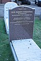 Jack Rosenthal's grave, Golders Green, London.jpg 2,056 × 3,088; 1.74 MB
-
 Junction of Templars Avenue and St Georges Road - geograph.org.uk - 2622977.jpg 1,600 × 1,200; 446 KB
-
 King Alfred School, London 1.jpg 4,096 × 3,072; 5.7 MB
-
 King Alfred School, London 2.jpg 4,096 × 3,072; 5.21 MB
-
 Kwik Fit, Temple Fortune - geograph.org.uk - 626819.jpg 640 × 427; 119 KB
-
 Leeside Crescent, Golders Green - geograph.org.uk - 3162218.jpg 2,048 × 1,536; 1.51 MB
-
 Leeside Crescent, Golders Green - geograph.org.uk - 4495479.jpg 2,304 × 1,728; 854 KB
-
 Leeside Crescent, Golders Green - geograph.org.uk - 4495480.jpg 2,304 × 1,728; 856 KB
-
 Leeside Crescent, NW11 (2) - geograph.org.uk - 2604552.jpg 640 × 480; 82 KB
-
 Leeside Crescent, NW11 (3) - geograph.org.uk - 2604560.jpg 640 × 480; 92 KB
-
 Leeside Crescent, NW11 (4) - geograph.org.uk - 2604563.jpg 640 × 480; 111 KB
-
 Leeside Crescent, NW11 (5) - geograph.org.uk - 2604566.jpg 640 × 480; 92 KB
-
 Leeside Crescent, NW11 - geograph.org.uk - 2604251.jpg 640 × 480; 106 KB
-

-
 London Underground tube trains - Golders Green (16027485448).jpg 4,288 × 3,216; 3.41 MB
-
 Looking down Hoop Lane - geograph.org.uk - 676208.jpg 640 × 480; 69 KB
-
 M&S sign c1990.jpg 1,760 × 1,232; 398 KB
-
 Marie Lloyd - 37 Woodstock Road Golders Green NW11 8ES.jpg 1,500 × 2,000; 733 KB
-
 MARY MACARTHUR - 42 Woodstock Road Golders Green London NW11 8ER.jpg 2,000 × 1,500; 1,002 KB
-

-
 Menorah, Finchley Road NW11 - geograph.org.uk - 1617263.jpg 480 × 640; 76 KB
-
 Middleway - geograph.org.uk - 359608.jpg 525 × 631; 122 KB
-
 Mini Roundabout - geograph.org.uk - 529380.jpg 640 × 480; 124 KB
-
 Mitzvah tank - Golders Green - 2008.jpg 1,982 × 1,214; 566 KB
-
 Montpelier Rise, NW11 (2) - geograph.org.uk - 2605533.jpg 640 × 480; 83 KB
-
 Montpelier Rise, NW11 (3) - geograph.org.uk - 2605536.jpg 640 × 480; 87 KB
-
 Montpelier Rise, NW11 - geograph.org.uk - 2605513.jpg 640 × 480; 104 KB
-
 Montrose Court - geograph.org.uk - 626789.jpg 497 × 640; 212 KB
-

-
 North Circular Road, London NW11 - geograph.org.uk - 404352.jpg 640 × 479; 110 KB
-

-
 Northern Rock Customers, September 14, 2007.jpg 2,048 × 1,536; 373 KB
-
 Oakfields Rd church.jpg 1,600 × 1,200; 553 KB
-
 Path along the edge of Basing Hill Park - geograph.org.uk - 4372122.jpg 4,000 × 3,000; 4.31 MB
-
 Path along the edge of Basing Hill Park - geograph.org.uk - 4372126.jpg 4,000 × 3,000; 4.32 MB
-
-
 Path from Bridge Lane to Cranbourne Gardens - geograph.org.uk - 4159512.jpg 2,304 × 1,728; 846 KB
-
 Path from Leeside Crescent to St George's Close - geograph.org.uk - 4159517.jpg 1,728 × 2,304; 865 KB
-

-
 Portsdown Avenue, NW11 - geograph.org.uk - 2604612.jpg 640 × 479; 83 KB
-
 Railway bridge over Woodville Road - geograph.org.uk - 2285171.jpg 640 × 480; 109 KB
-
 Ravenscroft Avenue - geograph.org.uk - 1142076.jpg 640 × 418; 132 KB
-
 Ravenscroft Avenue, Golders Green.jpg 3,264 × 2,448; 1.12 MB
-
 Ravenscroft Avenue, NW11 (2) - geograph.org.uk - 2605213.jpg 640 × 480; 92 KB
-
 Ravenscroft Avenue, NW11 (3) - geograph.org.uk - 2605249.jpg 640 × 480; 98 KB
-
 Ravenscroft Avenue, NW11 (4) - geograph.org.uk - 2605271.jpg 640 × 480; 83 KB
-
 Ravenscroft Avenue, NW11 - geograph.org.uk - 2605200.jpg 640 × 480; 101 KB
-
 Ridge Hill, NW11 - geograph.org.uk - 2605692.jpg 640 × 480; 72 KB
-
 River Brent - geograph.org.uk - 404359.jpg 640 × 479; 185 KB
-
-
 Rodborough Road, Golders Green - geograph.org.uk - 2390548.jpg 1,600 × 1,200; 544 KB
-
 Rotherwick Road NW11 - geograph.org.uk - 1624750.jpg 640 × 480; 78 KB
-

-
 Rotherwick Road, Golders Green - geograph.org.uk - 197806.jpg 640 × 480; 76 KB
-
 Rotherwick Road, Golders Green - geograph.org.uk - 4107426.jpg 2,304 × 1,728; 824 KB
-
 Route 13 Routemaster in Golders Green.jpg 1,600 × 1,200; 373 KB
-
 Russell Gardens, Golders Green - geograph.org.uk - 4495840.jpg 2,304 × 1,728; 820 KB
-
 Russell Gardens, Golders Green - geograph.org.uk - 4495841.jpg 2,304 × 1,728; 838 KB
-
 Sandringham Road, NW11 (2) - geograph.org.uk - 2605649.jpg 640 × 480; 87 KB
-
 Sandringham Road, NW11 - geograph.org.uk - 2605539.jpg 640 × 480; 93 KB
-
 Shops and war memorial, Golders Green - geograph.org.uk - 3681822.jpg 750 × 563; 105 KB
-
 Shops on Russell Gardens, Golders Green - geograph.org.uk - 4495839.jpg 2,200 × 1,580; 1.4 MB
-
 Sneath Avenue at the junction of Golders Green Road - geograph.org.uk - 4495865.jpg 2,304 × 1,728; 820 KB
-
 Sneath Avenue, Golders Green - geograph.org.uk - 4495858.jpg 1,728 × 2,304; 863 KB
-
 St Mary and Archangel Michael Church - geograph.org.uk - 4159504.jpg 2,304 × 1,728; 789 KB
-
 St Mary and Archangel Michael Church - geograph.org.uk - 4159507.jpg 1,728 × 2,304; 829 KB
-
 St Marys Rd - geograph.org.uk - 55316.jpg 640 × 482; 123 KB
-
 St. Andrew's Road, NW11 - geograph.org.uk - 2604615.jpg 640 × 480; 103 KB
-
 St. George's Road, NW11 (2) - geograph.org.uk - 2604580.jpg 640 × 480; 79 KB
-
 St. George's Road, NW11 (3) - geograph.org.uk - 2604585.jpg 640 × 480; 74 KB
-
 St. George's Road, NW11 - geograph.org.uk - 2604577.jpg 640 × 480; 88 KB
-
 St. John's Road, NW11 - geograph.org.uk - 2604633.jpg 640 × 479; 104 KB
-
 St. Johns Road - geograph.org.uk - 1142067.jpg 640 × 427; 181 KB
-
 Sunday Morning Joggers - geograph.org.uk - 359575.jpg 480 × 640; 164 KB
-
 Sunset in Wycombe Gardens, London NW11 - geograph.org.uk - 392132.jpg 640 × 459; 128 KB
-
 Sunset over Golders Green - geograph.org.uk - 2172364.jpg 640 × 480; 30 KB
-
 Templars Avenue - geograph.org.uk - 1142064.jpg 640 × 417; 182 KB
-
 Templars Avenue, Golders Green - geograph.org.uk - 2152972.jpg 1,600 × 1,200; 330 KB
-
 Templars Avenue, Golders Green - geograph.org.uk - 2152973.jpg 1,600 × 1,200; 514 KB
-
 Templars Avenue, NW11 (2) - geograph.org.uk - 2596704.jpg 640 × 480; 90 KB
-
 Templars Avenue, NW11 (3) - geograph.org.uk - 2604594.jpg 640 × 480; 101 KB
-
 Templars Avenue, NW11 (4) - geograph.org.uk - 2604602.jpg 640 × 480; 85 KB
-
 Templars Avenue, NW11 - geograph.org.uk - 2596661.jpg 640 × 480; 85 KB
-
 Templars Avenue, NW11 - geograph.org.uk - 2596666.jpg 640 × 480; 90 KB
-
 Temple Fortune Garden Centre - geograph.org.uk - 626818.jpg 640 × 427; 184 KB
-

-
 The Drive, Golders Green - geograph.org.uk - 3247886.jpg 4,000 × 3,000; 2.12 MB
-
 The Drive, Golders Green - geograph.org.uk - 4495440.jpg 2,304 × 1,728; 822 KB
-
 The Drive, Golders Green - geograph.org.uk - 4495962.jpg 2,304 × 1,728; 832 KB
-
 The Drive, NW11 (2) - geograph.org.uk - 2605518.jpg 640 × 480; 109 KB
-
 The Drive, NW11 - geograph.org.uk - 2605508.jpg 640 × 480; 94 KB
-
 The entrance to Basing Hill Park - geograph.org.uk - 4217164.jpg 2,304 × 1,728; 808 KB
-
 The Grove, NW11 - geograph.org.uk - 2605501.jpg 640 × 480; 124 KB
-
 The Ridgeway, Golders Green - geograph.org.uk - 1640401.jpg 640 × 480; 55 KB
-
 The Ridgeway, NW11 (2) - geograph.org.uk - 2605688.jpg 640 × 480; 106 KB
-
 The Ridgeway, NW11 (3) - geograph.org.uk - 2605697.jpg 640 × 480; 73 KB
-
 The Ridgeway, NW11 - geograph.org.uk - 2605682.jpg 640 × 480; 89 KB
-
 The Riding, NW11 - geograph.org.uk - 2605744.jpg 640 × 480; 82 KB
-
 Unitarian Church, Golders Green - geograph.org.uk - 676501.jpg 640 × 480; 111 KB
-
 Wall with buttresses in London.jpg 2,448 × 3,264; 1.22 MB
-
 Wentworth Road, Golders Green - geograph.org.uk - 4495954.jpg 2,304 × 1,728; 826 KB
-
 Wentworth Road, NW11 (2) - geograph.org.uk - 2604575.jpg 640 × 480; 81 KB
-
 Wentworth Road, NW11 (2) - geograph.org.uk - 2605240.jpg 640 × 480; 86 KB
-
 Wentworth Road, NW11 (3) - geograph.org.uk - 2605259.jpg 640 × 480; 96 KB
-
 Wentworth Road, NW11 - geograph.org.uk - 2596659.jpg 640 × 480; 86 KB
-
 Wentworth Road, NW11 - geograph.org.uk - 2604573.jpg 640 × 480; 74 KB
-
 Wessex Gardens, NW11 (2) - geograph.org.uk - 2605678.jpg 640 × 480; 89 KB
-
 Wessex Gardens, NW11 - geograph.org.uk - 2605669.jpg 640 × 480; 97 KB
-
 West Heath Drive NW11 - geograph.org.uk - 1651735.jpg 480 × 640; 54 KB
-
 Western Ave and the A406 - geograph.org.uk - 55320.jpg 640 × 482; 92 KB
-
 Western Avenue, Golders Green - geograph.org.uk - 4495507.jpg 2,304 × 1,728; 832 KB
-
 Woodstock Avenue, NW11 (2) - geograph.org.uk - 2605322.jpg 640 × 480; 84 KB
-
 Woodstock Avenue, NW11 (3) - geograph.org.uk - 2605660.jpg 640 × 480; 82 KB
-
 Woodstock Avenue, NW11 - geograph.org.uk - 2605310.jpg 640 × 480; 96 KB
-
 Woodstock Road - geograph.org.uk - 1884833.jpg 1,600 × 1,044; 664 KB
-
 Woodstock Road at the junction of The Drive - geograph.org.uk - 4179776.jpg 2,304 × 1,728; 1.09 MB
-
 Woodstock Road, Golders Green - geograph.org.uk - 4495961.jpg 2,304 × 1,728; 862 KB
-
 Woodstock Road, NW11 (2) - geograph.org.uk - 2605703.jpg 640 × 480; 92 KB
-
 Woodstock Road, NW11 (3) - geograph.org.uk - 2605708.jpg 640 × 480; 93 KB
-
 Woodstock Road, NW11 - geograph.org.uk - 2605700.jpg 640 × 480; 72 KB
-
 Woodville Road - geograph.org.uk - 2907794.jpg 640 × 427; 91 KB
-
 Woodville Road, NW11 - geograph.org.uk - 2605584.jpg 640 × 480; 80 KB


_-_geograph.org.uk_-_2604268.jpg)


_-_geograph.org.uk_-_2605525.jpg)


.jpg)


_-_geograph.org.uk_-_2605559.jpg)
_-_geograph.org.uk_-_2605630.jpg)
_-_geograph.org.uk_-_2605633.jpg)
_-_geograph.org.uk_-_2605645.jpg)


_-_geograph.org.uk_-_2604552.jpg)
_-_geograph.org.uk_-_2604560.jpg)
_-_geograph.org.uk_-_2604563.jpg)
_-_geograph.org.uk_-_2604566.jpg)

.jpg)


_-_geograph.org.uk_-_2605533.jpg)
_-_geograph.org.uk_-_2605536.jpg)


_at_Junction_of_Brent_Street_(NW4)_-_geograph.org.uk_-_404348.jpg)


_-_geograph.org.uk_-_2605213.jpg)
_-_geograph.org.uk_-_2605249.jpg)
_-_geograph.org.uk_-_2605271.jpg)


.jpg)


_-_geograph.org.uk_-_2605649.jpg)


_-_geograph.org.uk_-_2604580.jpg)
_-_geograph.org.uk_-_2604585.jpg)


_-_geograph.org.uk_-_2596704.jpg)
_-_geograph.org.uk_-_2604594.jpg)
_-_geograph.org.uk_-_2604602.jpg)


_-_geograph.org.uk_-_2605518.jpg)


_-_geograph.org.uk_-_2605688.jpg)
_-_geograph.org.uk_-_2605697.jpg)


_-_geograph.org.uk_-_2604575.jpg)
_-_geograph.org.uk_-_2605240.jpg)
_-_geograph.org.uk_-_2605259.jpg)


_-_geograph.org.uk_-_2605678.jpg)


_-_geograph.org.uk_-_2605322.jpg)
_-_geograph.org.uk_-_2605660.jpg)


_-_geograph.org.uk_-_2605703.jpg)
_-_geograph.org.uk_-_2605708.jpg)


_1971_AEC_Swift_Park_Royal,_Golders_Green,_route_240A,_April_1978.jpg)