Category:Gollhofen
Jump to navigation
Jump to search
municipality of Germany    | |||||
| Upload media | |||||
| Instance of |
| ||||
|---|---|---|---|---|---|
| Part of |
| ||||
| Location | Neustadt (Aisch)-Bad Windsheim, Middle Franconia, Bavaria, Germany | ||||
| Head of government |
| ||||
| Population |
| ||||
| Area |
| ||||
| Elevation above sea level |
| ||||
| official website | |||||
 | |||||
Subcategories
This category has the following 4 subcategories, out of 4 total.
G
S
Media in category "Gollhofen"
The following 7 files are in this category, out of 7 total.
-
 GollhofenWappen.png 78 × 84; 3 KB
-
 Wappen Gollhofen.svg 512 × 545; 39 KB
-
 Wappen von Gollhofen.svg 512 × 559; 66 KB
-
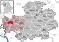 Gollhofen in NEA.svg 753 × 534; 1.46 MB
-
 GOLLHOFEN nieder.png 480 × 360; 5 KB
-
 GOLLHOFEN nieder.svg 512 × 427; 21 KB
-
 Luftaufnahme Frankana Freiko.jpg 4,000 × 2,250; 3.26 MB


