Category:Golyy Shpil
Jump to navigation
Jump to search
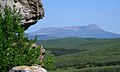
 Вид с вершины на северо-запад | |||||
| Upload media | |||||
| Instance of | |||||
|---|---|---|---|---|---|
| Subclass of | |||||
| Location | Simferopol Raion, Autonomous Republic of Crimea, Ukraine | ||||
| Mountain range | |||||
| Elevation above sea level |
| ||||
 | |||||
Media in category "Golyy Shpil"
The following 3 files are in this category, out of 3 total.
-
 Вид с вершины Голого Шпиля на северо-запад.jpg 2,559 × 1,211; 971 KB
-
 Гора Чатыр-Даг, Крым.jpg 2,048 × 1,221; 835 KB
-
 Хребет Кыз-Лур и Голый шпиль вид с Эклизи-Бурун.jpg 2,047 × 592; 317 KB
