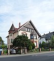
Category:Grünberger Straße 28 (Alsfeld)
Jump to navigation
Jump to search
| Object location | | View all coordinates using: OpenStreetMap |
|---|
This is the category of the Hessian Kulturdenkmal (cultural monument) with the ID 13061 (Wikidata)
|
| Upload media | |||||
| Instance of | |||||
|---|---|---|---|---|---|
| Location | Alsfeld, Vogelsbergkreis, Giessen Government Region, Hesse, Germany | ||||
| Heritage designation | |||||
 | |||||
Media in category "Grünberger Straße 28 (Alsfeld)"
The following 3 files are in this category, out of 3 total.
-
 Alsfeld, Grünberger Straße 28 (1).jpg 5,291 × 4,664; 13.81 MB
-
 Alsfeld, Grünberger Straße 28 (2).JPG 3,234 × 4,917; 6.32 MB
-
 Alsfeld, Grünberger Straße 28.jpg 4,081 × 4,598; 10.35 MB
.jpg)
.JPG)
