Category:Grafmonument Familie Van Blocklant (Megen)
Jump to navigation
Jump to search
| Object location | | View all coordinates using: OpenStreetMap |
|---|
 | |||||
| Upload media | |||||
| Instance of |
| ||||
|---|---|---|---|---|---|
| Part of | |||||
| Location | Oss, North Brabant, Netherlands | ||||
| Street address |
| ||||
| Heritage designation |
| ||||
 | |||||
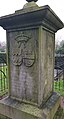
Nederlands: Grafmonument van de adellijke familie Van Blocklant op het R.K. kerkhof van Megen, dateert uit 1861
|
This is a category about rijksmonument number 516608
|
| Address |
|
Media in category "Grafmonument Familie Van Blocklant (Megen)"
The following 5 files are in this category, out of 5 total.
-
 Begraafplaats Megen 2.jpg 2,268 × 3,908; 7.29 MB
-
 Begraafplaats Megen 3.jpg 2,122 × 3,955; 4.94 MB
-
 Begraafplaats Megen.jpg 2,268 × 3,963; 5.74 MB
-
 Familiegraf van Blocklandt - Megen - 20152779 - RCE.jpg 788 × 1,200; 243 KB
-
 Megen Rijksmonument 516608 graf Van Blocklant begraafplaats Schoolstraat.JPG 2,736 × 3,648; 3.6 MB


