Category:Gramuntill
Jump to navigation
Jump to search
| Object location | | View all coordinates using: OpenStreetMap |
|---|
human settlement in Spain  Lloc on es troba Gramuntill | |||||
| Upload media | |||||
| Instance of | |||||
|---|---|---|---|---|---|
| Location | La Pobla de Segur, Pallars Jussà, Province of Lleida, Catalonia | ||||
| Elevation above sea level |
| ||||
 | |||||
Català: Gramuntill, nucli del municipi de la Pobla de Segur (Pallars Jussà)
Subcategories
This category has the following 3 subcategories, out of 3 total.
B
- Borda del Ros (1 F)
T
Media in category "Gramuntill"
The following 4 files are in this category, out of 4 total.
-
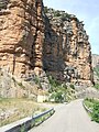
 Collegats-Queralt.JPG 4,896 × 3,672; 5.16 MB
-
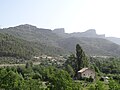
 La Pobla de Segur. Gramuntill 1.JPG 2,592 × 1,944; 1.28 MB
-
 La Pobla de Segur. Gramuntill. Lloc on era l'Hostal del Pas.JPG 1,944 × 2,592; 1.2 MB
-
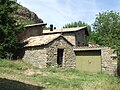 La Pobla de Segur. Gramuntill. Sant Miquel 5.JPG 2,592 × 1,944; 1.27 MB


