Category:Granary in Krasnystaw
Jump to navigation
Jump to search
| Object location | | View all coordinates using: OpenStreetMap |
|---|
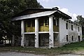
Polski: Krasnystaw, ul. M. Konopnickiej 3 - spichrz I poł XIX w.
hambar in Krasnystaw, Lublin Voivodeship, Poland .jpg) | |||||
| Upload media | |||||
| Instance of | |||||
|---|---|---|---|---|---|
| Location | Krasnystaw, Krasnystaw County, Lublin Voivodeship, Poland | ||||
| Street address |
| ||||
| Heritage designation |
| ||||
| Inception |
| ||||
 | |||||
Media in category "Granary in Krasnystaw"
The following 4 files are in this category, out of 4 total.
-
 Krasnystaw, Gminny Ośrodek Pomocy Społecznej - fotopolska.eu (320446).jpg 1,371 × 1,028; 316 KB
-
 Krasnystaw, Gminny Ośrodek Pomocy Społecznej - fotopolska.eu (320448).jpg 1,371 × 1,028; 329 KB
-
 Spichlerz Krasnystaw.JPG 5,184 × 3,456; 5.41 MB
-
 Spichrz (1 poł. XIX).jpg 4,288 × 2,848; 6.88 MB
.jpg)
.jpg)
