Category:Grave of Prieur (Père-Lachaise, division 62)
Jump to navigation
Jump to search
| Grave of Prieur (Père-Lachaise, division 62) | |||||||||||||||||||||||
|---|---|---|---|---|---|---|---|---|---|---|---|---|---|---|---|---|---|---|---|---|---|---|---|
| |||||||||||||||||||||||

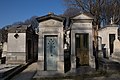
sepulchral chapel located in Père-Lachaise Cemetery - Division 62, in Paris, in France  | |||||
| Upload media | |||||
| Instance of | |||||
|---|---|---|---|---|---|
| Location | Père-Lachaise Cemetery - Division 62, Quartier du Père-Lachaise, 20th arrondissement of Paris, Paris, Grand Paris | ||||
| Collection | |||||
 | |||||
Media in category "Grave of Prieur (Père-Lachaise, division 62)"
The following 6 files are in this category, out of 6 total.
-
 Père-Lachaise - Division 62 - Chemin Luzarraga 13.jpg 5,184 × 3,456; 11.45 MB
-
 Père-Lachaise - Division 62 - Establie 01.jpg 5,760 × 3,840; 13.69 MB
-
 Père-Lachaise - Division 62 - Prieur 01.jpg 2,362 × 3,545; 6.51 MB
-
 Père-Lachaise - Division 62 - Prieur 02.jpg 2,650 × 3,975; 8.33 MB
-
 Père-Lachaise - Division 62 - Prieur 03.jpg 5,184 × 3,456; 9.24 MB
-
 Père-Lachaise - Division 62 - Prieur 04.jpg 5,184 × 3,456; 9.88 MB


