Category:Great Northern Basin, Langley Mill
Jump to navigation
Jump to search
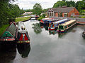
Media relating to the basin that formed the junction of the Erewash, Cromford, and Nottingham canals at Langley Mill, Amber Valley, Derbyshire, England.
| Object location | | View all coordinates using: OpenStreetMap |
|---|
Media in category "Great Northern Basin, Langley Mill"
The following 11 files are in this category, out of 11 total.
-
 British Waterways junction sign, Langley Mill - geograph.org.uk - 4294310.jpg 1,024 × 768; 311 KB
-
 Canal Basin - Langley Mill - geograph.org.uk - 1716648.jpg 3,072 × 2,304; 2.9 MB
-

-
 Canal junction, Langley Mill - geograph.org.uk - 4294357.jpg 1,024 × 768; 161 KB
-
 Cromford Canal, Langley Mill - geograph.org.uk - 551191.jpg 640 × 428; 97 KB
-
 Great Northern Basin Langley Mill - geograph.org.uk - 18226.jpg 640 × 480; 130 KB
-
 Great Northern Basin, Langley Mill - geograph.org.uk - 551177.jpg 640 × 428; 102 KB
-

-
 Langley Mill (Great Northern) basin of the Erewash Canal - Pump House - panoramio.jpg 3,264 × 2,448; 2.72 MB
-
 Langley Mill (Great Northern) basin of the Erewash Canal - Pump House engine - panoramio.jpg 3,264 × 2,448; 2.63 MB
-
 North end of Nottingham Canal, Langley Mill - geograph.org.uk - 4294342.jpg 1,024 × 768; 223 KB


_basin_of_the_Erewash_Canal_-_panoramio_-_mattjenniepearson_(1).jpg)
_basin_of_the_Erewash_Canal_-_Pump_House_-_panoramio.jpg)
_basin_of_the_Erewash_Canal_-_Pump_House_engine_-_panoramio.jpg)
