Category:Grenier (Clos du Moulin 9b, Perrefitte)
Jump to navigation
Jump to search
| Object location | | View all coordinates using: OpenStreetMap |
|---|
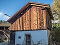
rural storage building in Perrefitte in the canton of Bern, Switzerland ,_Perrefitte_BE_20221025-jag9889.jpg) | |||||
| Upload media | |||||
| Instance of | |||||
|---|---|---|---|---|---|
| Part of | |||||
| Location | Perrefitte, Bernese Jura administrative district, Bernese Jura administrative region, Bern, Switzerland | ||||
| Street address |
| ||||
| Heritage designation |
| ||||
| Inception |
| ||||
 | |||||
Media in category "Grenier (Clos du Moulin 9b, Perrefitte)"
This category contains only the following file.
-
 Speicher (1680), Perrefitte BE 20221025-jag9889.jpg 4,608 × 3,456; 11.66 MB