Category:Grey River
Jump to navigation
Jump to search
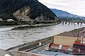
Deutsch: Die Mündung des Grey River wird durch eine große Sandbank abgeschlossen, die als Gefahrenzone für die Schifffahrt in der Mündung gilt. (→Grey River (Neuseeland))
English: The Grey River / Māwheranui is located in the northwest of the South Island of New Zealand. It rises in Lake Christabel, one of numerous small lakes on the western side of the Southern Alps,12 kilometres southwest of the Lewis Pass, and runs westward for 120 kilometres before draining into the Tasman Sea at Greymouth. The river was named by explorer Thomas Brunner in honour of New Zealand politician Sir George Grey. The official name of the river was changed to Grey River / Māwheranui in 1998 by way of the Ngai Tahu Claims Settlement Act 1998 The Maori name for the river system and surrounding area is Māwhera, with Māwheranui being distinguished from the northern brach Little Grey River / Māwheraiti. (→Grey River)
river in New Zealand  | |||||
| Upload media | |||||
| Instance of | |||||
|---|---|---|---|---|---|
| Location | West Coast Region, New Zealand | ||||
| Length |
| ||||
| Origin of the watercourse |
| ||||
| Mouth of the watercourse | |||||
| Tributary |
| ||||
 | |||||
Subcategories
This category has the following 3 subcategories, out of 3 total.
Media in category "Grey River"
The following 32 files are in this category, out of 32 total.
-
 Brunner Mine 2011 002.JPG 3,872 × 2,592; 4.33 MB
-
 Cobden across the Grey River, 1987. CC126.jpg 2,226 × 1,470; 2.16 MB
-
 Cobden Bridge, West Coast, New Zealand.jpg 3,508 × 2,289; 3.85 MB
-
 Cobden Quarry across the Grey River, 1987. CC127.jpg 2,226 × 1,470; 2.25 MB
-
 Cobden Quarry across the Grey River, 1987. CC128.jpg 2,237 × 1,470; 2.38 MB
-
 Cobden, West Coast, New Zealand.jpg 3,573 × 2,451; 3.68 MB
-
 Grey River east of Brunner bridge (from Brunner suspension bridge).jpg 4,896 × 3,264; 5.74 MB
-
 Grey River near Greymouth 01.jpg 3,712 × 1,151; 2.14 MB
-
 Grey River near Greymouth 02.jpg 4,137 × 499; 1.35 MB
-
 Grey River near Greymouth 03.jpg 3,759 × 1,760; 4.83 MB
-
 Grey.river.jpg 2,832 × 2,128; 539 KB
-
 Greymouth at sunset.jpg 5,183 × 2,912; 8.65 MB
-
 Greymouth Grey River 002.JPG 3,872 × 2,592; 3.72 MB
-
 Greymouth Wharf and Cranes, 1987. CC092.jpg 2,072 × 1,470; 1.51 MB
-
 Hugh Watt opening Big Grey River Bridge.jpg 477 × 358; 43 KB
-
 ISS018-E-40428 - View of Chile.jpg 3,072 × 2,040; 586 KB
-
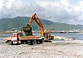 Loading Ferguson Bros truck with shingle from Grey River Bank, Cobden Side, 1987. CC118.jpg 2,093 × 1,470; 2.19 MB
-
 Looking across the Grey River from Cobden to Mawhera Quay, Greymouth, 1987. CC121.jpg 2,237 × 1,470; 2.67 MB
-
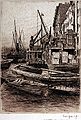 Mortimer Menpes28.jpg 540 × 800; 157 KB
-
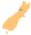 NZ-Grey R.png 1,234 × 1,395; 254 KB
-
 Old Cobden Bridge pillars in Grey River and Rail Bridge, Greymouth, 1987. CC129.jpg 2,103 × 1,470; 2.31 MB
-
 Rail and road bridges across the Grey River near Cobden (21453224719).jpg 6,455 × 4,726; 2.59 MB
-

-
-
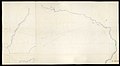
 Survey Office - Plan of Maruia & Grey River.jpg 1,080 × 603; 30 KB
-
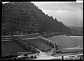
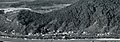
 Taylorville and Wallsend.jpg 999 × 666; 188 KB
-

-
 Wallsend (cropped).jpg 806 × 284; 73 KB
-
 Ōkārito + Whitebaiting • Nimmo • MRD 18.jpg 3,600 × 2,401; 5.03 MB
-
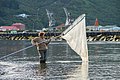 Ōkārito + Whitebaiting • Nimmo • MRD 19.jpg 3,600 × 2,401; 5.23 MB
-
 Ōkārito + Whitebaiting • Nimmo • MRD 20.jpg 3,600 × 2,401; 3.85 MB
-
 Ōkārito + Whitebaiting • Nimmo • MRD 21.jpg 3,600 × 2,401; 4.33 MB


.jpg)


.jpg)
.jpg)
.jpg)


.jpg)


.jpg)