Category:Grinsel 71, Den Dungen
Jump to navigation
Jump to search
| Object location | | View all coordinates using: OpenStreetMap |
|---|
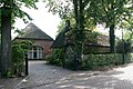
farmhouse in Sint-Michielsgestel, Netherlands  | |||||
| Upload media | |||||
| Instance of | |||||
|---|---|---|---|---|---|
| Location | Den Dungen, North Brabant, Netherlands | ||||
| Street address |
| ||||
| Located on street |
| ||||
| Heritage designation |
| ||||
 | |||||
|
This is a category about rijksmonument number 329592
|
| Address |
|
Media in category "Grinsel 71, Den Dungen"
The following 22 files are in this category, out of 22 total.
-
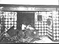 Aanzicht schouw woonkamer - Den Dungen - 20449317 - RCE.jpg 1,200 × 900; 195 KB
-
 Aardappelkelder onder bakoven - Den Dungen - 20449308 - RCE.jpg 1,200 × 900; 119 KB
-
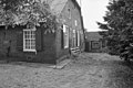
 Achtergevel - Den Dungen - 20449314 - RCE.jpg 1,200 × 900; 101 KB
-
 Achtergevel - Den Dungen - 20449315 - RCE.jpg 1,200 × 900; 172 KB
-
 Achtergevel en schuur - Den Dungen - 20065200 - RCE.jpg 1,200 × 802; 272 KB
-
 Bakoven - Den Dungen - 20449309 - RCE.jpg 1,200 × 900; 191 KB
-
 Den Dungen - Grinsel 71 - boerderij (1).jpg 3,888 × 2,592; 3.05 MB
-
 Den Dungen - Grinsel 71 - boerderij.jpg 3,888 × 2,592; 7.91 MB
-
 Detail metselwerk - Den Dungen - 20449313 - RCE.jpg 1,200 × 900; 195 KB
-
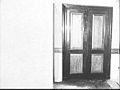
 Deur slaapkamer - Den Dungen - 20449319 - RCE.jpg 1,200 × 900; 95 KB
-
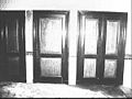
 Kastdeuren in slaapkamer - Den Dungen - 20449311 - RCE.jpg 1,200 × 900; 91 KB
-
 Kastwand in woonkamer - Den Dungen - 20449304 - RCE.jpg 1,200 × 900; 105 KB
-
 Kastwand in woonkamer - Den Dungen - 20449305 - RCE.jpg 1,200 × 900; 130 KB
-
 Linker zij- en achtergevel - Den Dungen - 20065199 - RCE.jpg 1,200 × 797; 247 KB
-
 Linker zijwang schouw - Den Dungen - 20449307 - RCE.jpg 1,200 × 900; 150 KB
-
 Rechter zijwang schouw - Den Dungen - 20449310 - RCE.jpg 1,200 × 900; 132 KB
-
 Schouw in slaapkamer - Den Dungen - 20449312 - RCE.jpg 1,200 × 900; 130 KB
-
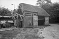 Schuur - Den Dungen - 20065201 - RCE.jpg 1,200 × 801; 247 KB
-
 Sopketel en pomp - Den Dungen - 20449306 - RCE.jpg 1,200 × 900; 112 KB
-
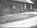
 Voorgevel - Den Dungen - 20065198 - RCE.jpg 1,200 × 805; 266 KB
-
 Voorgevel - Den Dungen - 20449318 - RCE.jpg 1,200 × 900; 147 KB
-
 Zijgevel - Den Dungen - 20449316 - RCE.jpg 1,200 × 900; 157 KB


.jpg)


