Category:Großsteingrab Am Osteresch
Jump to navigation
Jump to search
| Object location | | View all coordinates using: OpenStreetMap |
|---|
 | |||||
| Upload media | |||||
| Instance of |
| ||||
|---|---|---|---|---|---|
| Location | Stavern, Sögel, Emsland, Lower Saxony, Germany | ||||
 | |||||
Media in category "Großsteingrab Am Osteresch"
The following 19 files are in this category, out of 19 total.
-
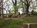 Am Osteresch.jpg 4,128 × 3,096; 8.62 MB
-
 Großsteingrab am Osteresch.JPG 3,648 × 2,736; 8.01 MB
-
 NLD Großsteingrab Klein-Stavern 1.jpg 6,000 × 4,000; 3.96 MB
-
 Stavern - Am Steinberg + Am Osteresch 01 ies.jpg 5,616 × 3,744; 16.97 MB
-
 Stavern - Am Steinberg + Am Osteresch 02 ies.jpg 3,744 × 5,616; 17.23 MB
-
 Stavern - Am Steinberg - Am Osteresch 01 ies.jpg 5,616 × 3,744; 34.75 MB
-
 Stavern - Am Steinberg - Am Osteresch 02 ies.jpg 5,616 × 3,744; 31.07 MB
-
 Stavern - Am Steinberg - Am Osteresch 03 ies.jpg 5,616 × 3,745; 22.06 MB
-
 Stavern - Am Steinberg - Am Osteresch 04 ies.jpg 5,616 × 3,744; 30.73 MB
-
 Stavern - Am Steinberg - Am Osteresch 05 ies.jpg 5,616 × 3,744; 29.03 MB
-
 Stavern - Am Steinberg - Am Osteresch 06 ies.jpg 5,616 × 3,744; 29.97 MB
-
 Stavern - Am Steinberg - Am Osteresch 07 ies.jpg 5,616 × 3,744; 29.42 MB
-
 Stavern - Am Steinberg - Am Osteresch 08 ies.jpg 5,616 × 3,744; 29.51 MB
-
 Stavern - Am Steinberg - Am Osteresch 09 ies.jpg 5,616 × 3,744; 27.16 MB
-
 Stavern - Am Steinberg - Am Osteresch 10 ies.jpg 5,616 × 3,744; 24.41 MB
-
 Stavern - Am Steinberg - Am Osteresch 11 ies.jpg 5,616 × 3,743; 27.04 MB
-
 Stavern - Am Steinberg - Am Osteresch 12 ies.jpg 5,616 × 3,744; 28.45 MB
-
 Stavern - Am Steinberg - Am Osteresch 13 ies.jpg 5,616 × 3,744; 28.22 MB
-
 Stavern - Am Steinberg - Am Osteresch 14 ies.jpg 5,616 × 3,744; 32.46 MB


