Category:Groenevecht
Jump to navigation
Jump to search
| Object location | | View all coordinates using: OpenStreetMap |
|---|
garden in Stichtse Vecht, Netherlands  | |||||
| Upload media | |||||
| Instance of | |||||
|---|---|---|---|---|---|
| Part of | |||||
| Location | Breukelen, Utrecht, Netherlands | ||||
| Street address |
| ||||
| Heritage designation |
| ||||
 | |||||
Nederlands: Groenevecht is een buitenplaats langs de rivier de Vecht in het Nederlandse dorp Breukelen. Ook wel Groene Vecht genoemd.
|
This is a category about rijksmonumentcomplex number 510516
|
Landhuis:
|
This is a category about rijksmonument number 510518
|
Historische tuin- en parkaanleg:
|
This is a category about rijksmonument number 510526
|
Tuinmanswoning:
|
This is a category about rijksmonument number 510529
|
Boerderij met zomerhuis:
|
This is a category about rijksmonument number 510530
|
Toegangshekken:
|
This is a category about rijksmonument number 510532
|
Toegangshekken:
|
This is a category about rijksmonument number 510534
|
Brug:
|
This is a category about rijksmonument number 510537
|
Brug:
|
This is a category about rijksmonument number 510538
|
Duiker:
|
This is a category about rijksmonument number 510539
|
| Address |
|
Media in category "Groenevecht"
The following 19 files are in this category, out of 19 total.
-
 3621 Breukelen, Netherlands - panoramio (22).jpg 2,048 × 1,148; 621 KB
-
 Aanzicht - Breukelen - 20042276 - RCE.jpg 1,200 × 959; 306 KB
-
 Aanzicht - Breukelen - 20042277 - RCE.jpg 1,200 × 955; 296 KB
-
 Breukelen - Groenevecht toegangshek RM510532.JPG 4,405 × 3,325; 2.16 MB
-
 Breukelen - Groenevecht tuinaanleg RM510526.JPG 3,420 × 2,380; 1.32 MB
-
 Breukelen - Groenevecht tuinmanswoning RM510529.JPG 4,385 × 3,285; 1.53 MB
-
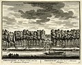
 Buitenplaats Groenevecht aan de Vecht bij Breukelen in 1719.jpg 1,200 × 933; 331 KB
-
 Exterieur GEZICHT OP HET NOORDELIJKE HEK - Breukelen - 20301433 - RCE.jpg 1,192 × 1,200; 411 KB
-
 Exterieur GEZICHT OP HET ZUIDELIJKE HEK - Breukelen - 20301434 - RCE.jpg 1,188 × 1,200; 500 KB
-
 Groene Vecht", vooraanzicht - Breukelen - 20042279 - RCE.jpg 1,200 × 805; 280 KB
-
 HUA-135622-Gezicht over de Vecht op de buitenplaats Groenevecht bij Breukelen.jpg 3,793 × 3,003; 4.97 MB
-
 HUA-135623-Gezicht op het huis en de tuin van de buitenplaats Groenevecht bij Breukelen.jpg 3,809 × 3,019; 4.87 MB
-
 HUA-135726-Gezicht over de Vecht op de buitenplaats Groenevecht bij Breukelen.jpg 3,891 × 3,080; 5.58 MB
-
 HUA-135727-Gezicht op het huis en de tuin van de buitenplaats Groenevecht bij Breukelen.jpg 3,903 × 3,024; 5.41 MB
-
 HUA-201295-Gezicht over de Vecht op de buitenplaats Groenevecht bij Breukelen.jpg 2,008 × 1,576; 1.05 MB
-
 HUA-201296-Gezicht op het huis en de tuin van de buitenplaats Groenevecht bij Breukelen.jpg 2,013 × 1,563; 1.02 MB
-

-
 Overzicht voorgevel - Breukelen - 20363931 - RCE.jpg 1,200 × 1,196; 298 KB
-
 Overzicht voorgevel - Breukelen - 20363932 - RCE.jpg 1,197 × 1,200; 305 KB
.jpg)


