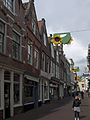
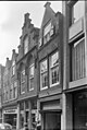
Category:Grote Spuistraat 7, Dordrecht
Jump to navigation
Jump to search
| Object location | | View all coordinates using: OpenStreetMap |
|---|
building in Dordrecht, Netherlands  | |||||
| Upload media | |||||
| Instance of | |||||
|---|---|---|---|---|---|
| Location | Dordrecht, South Holland, Netherlands | ||||
| Street address |
| ||||
| Located on street | |||||
| Heritage designation |
| ||||
 | |||||
|
This is a category about rijksmonument number 13419
|
| Address |
|
Media in category "Grote Spuistraat 7, Dordrecht"
The following 9 files are in this category, out of 9 total.
-
 Dordrecht - Grote Spuistraat 5 en 7.JPG 3,056 × 4,592; 4.27 MB
-
 Dordrecht Grote Spuistraat11.jpg 2,736 × 3,648; 5.05 MB
-
 Dordrecht Grote Spuistraat7.jpg 2,616 × 3,584; 4.38 MB
-
 Dordrecht Grote Spuistraat9.jpg 2,736 × 3,648; 5.19 MB
-
 Overzicht - Dordrecht - 20062060 - RCE.jpg 804 × 1,200; 173 KB
-
 Overzicht van de voorgevels - Dordrecht - 20379255 - RCE.jpg 1,187 × 1,200; 239 KB
-
 Voorgevel - Dordrecht - 20062066 - RCE.jpg 1,200 × 963; 289 KB
-
 Voorgevel - Dordrecht - 20062069 - RCE.jpg 960 × 1,200; 209 KB
-
 Voorgevels - Dordrecht - 20062061 - RCE.jpg 804 × 1,200; 177 KB


