Category:Gschnitz
Jump to navigation
Jump to search
municipality in Innsbruck-Land District, Tyrol, Austria    | |||||
| Upload media | |||||
| Instance of |
| ||||
|---|---|---|---|---|---|
| Location | Innsbruck-Land District, Tyrol, Austria | ||||
| Population |
| ||||
| Area |
| ||||
| Elevation above sea level |
| ||||
| Budget |
| ||||
| official website | |||||
 | |||||
Subcategories
This category has the following 17 subcategories, out of 17 total.
B
- Bremer Hütte (23 F)
C
F
- Fire station in Gschnitz (4 F)
- Friedhof Gschnitz (6 F)
H
- Habicht (Stubai Alps) (44 F)
I
- Innsbrucker Hütte (26 F)
L
- Laponesalm (10 F)
M
- Mühlendorf Gschnitz (29 F)
P
S
- Sandesbach (4 F)
T
- Tribulaunhütte (Austria) (18 F)
- Trogerhof, Gschnitz (3 F)
V
- Volksschule Gschnitz (3 F)
Ä
- Äußere Wetterspitze (3 F)
Media in category "Gschnitz"
The following 43 files are in this category, out of 43 total.
-
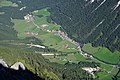 Blick auf Gschnitz.jpg 6,000 × 4,000; 10.25 MB
-
 Brausendercurrylolli.JPG 3,456 × 2,210; 1.43 MB
-
 Cruzifix in Gschnitz.jpg 2,592 × 3,888; 5.17 MB
-
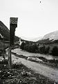 Austria, Gschnitz Fortepan 95352.jpg 3,601 × 5,137; 8.14 MB
-
 Gasthof zum Feuerstein gegen Schafkamm Feuerstein und Wetterspitzen Gschnitz.jpg 1,874 × 1,304; 634 KB
-
 Geigerwald.jpg 1,536 × 2,048; 1.15 MB
-
 Gschnitz 14.JPG 3,888 × 2,592; 2.29 MB
-
 Gschnitz 2.JPG 3,888 × 2,592; 3.65 MB
-
 Gschnitz Festner.jpg 6,000 × 4,000; 9.34 MB
-
 Gschnitz Gasthof Kuraten und Pfarrkirche gegen Kirchdachspitze.jpg 2,027 × 1,490; 452 KB
-
 Gschnitz Gasthof zum Feuerstein.jpg 1,374 × 1,869; 532 KB
-
 Gschnitz gegen Stubaier Alpen.jpg 1,876 × 1,342; 629 KB
-
 Gschnitz im Bezirk IL.png 645 × 645; 11 KB
-
 Gschnitz in Tirol Skilift.jpg 1,884 × 1,377; 561 KB
-
 Gschnitz Mitterhof 14.jpg 3,072 × 2,304; 3.6 MB
-
 Gschnitz Nr 36.jpg 3,888 × 2,592; 1.79 MB
-
 Gschnitz Plank-Hof.jpg 6,000 × 4,000; 8.38 MB
-
 Gschnitz Wegkreuz Festner.jpg 4,000 × 6,000; 7.38 MB
-
 Gschnitz-Alte-Mühle.jpg 1,342 × 1,890; 761 KB
-
 Gschnitz.jpg 5,907 × 3,654; 6.4 MB
-
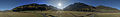 Gschnitztal Mitte 360 Pano.jpg 13,783 × 2,000; 19.52 MB
-
 Hochbehälter Enigeben (Gschnitz).jpg 4,160 × 3,120; 3.36 MB
-
 Ilmspitze und Kirchdachspitze bei Gschnitz.jpg 4,608 × 3,456; 11.99 MB
-
 Kreuzweg nach St. Magdalena, 5. Station.jpg 2,446 × 3,654; 6.69 MB
-
 Landschaftsschutzgebiet Serles-Habicht Zuckerhütl 01.jpg 3,888 × 2,592; 5.56 MB
-
 Landschaftsschutzgebiet Serles-Habicht Zuckerhütl 02.jpg 2,592 × 3,888; 4.49 MB
-
 Landschaftsschutzgebiet Serles-Habicht Zuckerhütl 03.jpg 2,592 × 3,888; 5.25 MB
-
 Landschaftsschutzgebiet Serles-Habicht Zuckerhütl 04.jpg 3,888 × 2,592; 5.9 MB
-
 Landschaftsschutzgebiet Serles-Habicht Zuckerhütl 05.jpg 3,888 × 2,592; 5.71 MB
-
 Landschaftsschutzgebiet Serles-Habicht Zuckerhütl 06.jpg 3,644 × 2,332; 2.68 MB
-
 Landschaftsschutzgebiet Serles-Habicht Zuckerhütl 07.jpg 3,888 × 2,592; 5.61 MB
-
 Landschaftsschutzgebiet Serles-Habicht Zuckerhütl 08.jpg 2,592 × 3,888; 4.37 MB
-
 Morning light in Gschnitztal.jpg 3,888 × 2,592; 4.67 MB
-
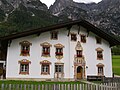
 Pfarrhaus Gschnitz.jpg 6,000 × 4,000; 8.53 MB
-
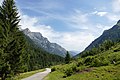
 Road between Gschnitz main village and Laponesalm 01.jpg 3,888 × 2,592; 5.44 MB
-
 Road between Gschnitz main village and Laponesalm 02.jpg 2,592 × 3,888; 5.58 MB
-
 Sankt Magdalena aus der Urknall.jpg 4,608 × 3,456; 13.75 MB
-
 Skulptur Manfred Pranger in Gschnitz.jpg 4,000 × 6,000; 10.06 MB
-
 T-Gschnitz-Ilmspitz-Kirchdach.jpg 3,369 × 2,068; 1.97 MB
-
 Timber in Tyrol 01.jpg 3,888 × 2,592; 5.72 MB
-
 Timber in Tyrol 02.jpg 3,888 × 2,592; 5.91 MB
-
 Timber in Tyrol 03.jpg 3,888 × 2,592; 5.76 MB
-
 Wappen at gschnitz.png 166 × 192; 3 KB


.jpg)


