Category:Gulf of Mannar
Pereiti į navigaciją
Jump to search

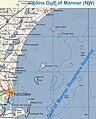
English: The Gulf of Mannar — a large shallow bay, that is an arm of the Laccadive Sea in the Indian Ocean.
- It lies between the southeastern tip of India and the west coast of Sri Lanka, in the Coromandel Coast Region, with widths between 160–200 kilometres (99–124 mi).
- A chain of low islands and reefs known as Adam's Bridge, also called Ramsethu, separates the Gulf of Mannar from the Palk Strait, which lies to the north between India and Sri Lanka. The en:Tambaraparani River of South India and en:Aruvi Aru of Sri Lanka drain into the Gulf. The Gulf of Mannar Biosphere Reserve is located here.
8°24′51″N 78°59′22″E / 8.41417°N 78.98944°E
gulf of the Indian Ocean between India and Sri Lanka  | |||||
| Įkelti mediją | |||||
| Tai yra | |||||
|---|---|---|---|---|---|
| Vieta |
| ||||
| Plotas |
| ||||
| Įteka | |||||
| Baseino šalis | |||||
 | |||||
Subkategorijos
Rodomos 2 subkategorijos (iš viso yra 2 subkategorijos).
P
T
Daugialypės terpės rinkmenos kategorijoje „Gulf of Mannar“
Rodomi 22 šios kategorijos rinkmenos (iš viso kategorijoje yra 22 rinkmenos).
-
 *The Palk Strait and the Gulf of Manaar, from a map by SDUK, 1831*.jpg 1 280 × 888; 196 KiB
-
 Admiralty Chart No 68b Palk Strait and Gulf of Mannar, Published 1862, New Edition 1935.jpg 18 351 × 11 208; 46,07 MiB
-
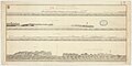 Admiralty Chart No 806 Views in the gulph of Manar, Published 1798.jpg 8 156 × 4 106; 7,27 MiB
-
 AMS Trivandrum (cropped) now Thiruvananthapuram costal region.jpg 862 × 1 149; 305 KiB
-
 AMS Trivandrum.jpg 5 000 × 3 819; 4,27 MiB
-
 AMS-Gulf of Mannar (SW).jpg 658 × 818; 539 KiB
-
 AMS-Gulf of Mannar.jpg 3 900 × 1 477; 4,02 MiB
-
 Clathria (Microciona) aceratoobtusa at Vilanguchalli Island, Gulf of Mannar.png 850 × 1 085; 525 KiB
-
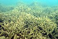 Deadcoral pho gulfofmannar 17nov2021 lrg.jpg 4 000 × 2 667; 3,37 MiB
-
 Deep Blue Ocean.jpg 5 312 × 2 988; 4,22 MiB
-
 Fishkill pho gulfofmannar 11oct2022 lrg.jpg 4 608 × 3 072; 5,11 MiB
-
 Greenbloom pho gulfofmannar 11oct2022 lrg.jpg 4 350 × 2 900; 911 KiB
-
 HMS St Fiorenzo and Piemontaise.jpg 540 × 430; 56 KiB
-
 Horizon becomes colourful.jpg 8 504 × 3 904; 7,45 MiB
-
 Indiaalgae oli2 2022266 lrg.jpg 5 035 × 3 357; 7,25 MiB
-
 Indiaalgae oli2 2022266.jpg 720 × 480; 171 KiB
-
 Islands of india in tamilnadu.jpg 5 312 × 2 988; 4,18 MiB
-
 It had to be done! (10567790013).jpg 1 536 × 2 048; 674 KiB
-
 Locatie Golf van Mannar.PNG 484 × 362; 13 KiB
-
 Mannar 79.03963E 9.52009N.jpg 1 280 × 958; 73 KiB
-
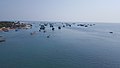
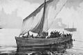 Pearling boat divers.jpg 600 × 401; 44 KiB
-
 RameshwaramScenicView.jpg 2 048 × 1 536; 766 KiB


_now_Thiruvananthapuram_costal_region.jpg)

.jpg)
_aceratoobtusa_at_Vilanguchalli_Island,_Gulf_of_Mannar.png)


.jpg)


