Category:Guntersville Lock and Dam
Jump to navigation
Jump to search
hydroelectric dam on the Tennessee River in Marshall County, in the U.S. state of Alabama  | |||||
| Upload media | |||||
| Instance of | |||||
|---|---|---|---|---|---|
| Location | Marshall County, Alabama | ||||
| Inception |
| ||||
| Nominal power capacity |
| ||||
| Length |
| ||||
| Drainage basin |
| ||||
| Reservoir created | |||||
 | |||||
Media in category "Guntersville Lock and Dam"
The following 16 files are in this category, out of 16 total.
-
 "Golden Eagle" passing through Guntersville Lock - NARA - 281168.jpg 1,765 × 3,000; 806 KB
-
 Alabama - Guntersville Dam through Helena - NARA - 23933399.jpg 4,350 × 3,364; 3.77 MB
-
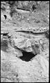 Blowing Spring at Honey Comb Bluff - NARA - 279812.jpg 1,800 × 3,000; 1.42 MB
-
 Guntersville Dam (1936) - Truck (9134562831).jpg 1,071 × 1,420; 679 KB
-
 Guntersville Dam (8386582379).jpg 640 × 480; 51 KB
-
 Guntersville Dam (8387667618).jpg 640 × 480; 54 KB
-
 Guntersville dam 2.jpg 1,538 × 992; 1.32 MB
-
 Guntersville Dam on the Tennessee River, Guntersville, Alabama LCCN2010639567.tif 6,144 × 4,096; 144.03 MB
-
 Guntersville Dam. (8386581859).jpg 640 × 480; 64 KB
-
 Guntersville Dam. (8386582381).jpg 640 × 480; 65 KB
-
 Guntersville dam.jpg 640 × 480; 60 KB
-
 Guntersville Lock and Dam (35816044661).jpg 1,600 × 2,400; 1.49 MB
-
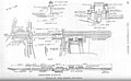 Guntersville-dam-design-tva1.jpg 1,553 × 963; 125 KB
-
 Map of the Tennessee Valley Authority - NARA - 195895.tif 2,000 × 1,226; 2.36 MB
-
 USACE Guntersville Lock and Dam.jpg 1,500 × 1,001; 525 KB
-


_-_Truck_(9134562831).jpg)
.jpg)
.jpg)
.jpg)
.jpg)

.jpg)


.jpg)