Category:Hôtel de Commune (Lignières)
Jump to navigation
Jump to search
| Object location | | View all coordinates using: OpenStreetMap |
|---|
administrative building in Lignières in the canton of Neuchâtel, Switzerland  | |||||
| Upload media | |||||
| Instance of | |||||
|---|---|---|---|---|---|
| Part of | |||||
| Location | Lignières, Littoral region, Neuchâtel, Switzerland | ||||
| Heritage designation | |||||
 | |||||
Media in category "Hôtel de Commune (Lignières)"
This category contains only the following file.
-
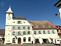 KGS-Nr 4034.JPG 4,896 × 3,672; 4.88 MB