Category:Hafod Arch
Jump to navigation
Jump to search
triumphal arch in Devil's Bridge  | |||||
| Upload media | |||||
| Instance of | |||||
|---|---|---|---|---|---|
| Location | Devil's Bridge, Ceredigion, Wales | ||||
| Heritage designation | |||||
| Elevation above sea level |
| ||||
 | |||||
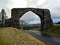
English: "The Arch", or Hafod Arch, next to (formerly: on) the B4574 road between Cwmystwyth and Devil's Bridge (Pontarfynach) is located at a pass (called "the pass of the loss of existence" in Welsh) near what was Hafod Estate (Hafod Uchtryd) in Ceredigion, Wales, United Kingdom. – It was constructed by Thomas Johnes in 1810 to commemorate George III's golden jubilee at the height of this king's national popularity, which sadly coincided with his near blindness, decline into ill-health and mental illness resulting in the regency by 1811 and the seclusion of George III until his death in 1820. – In 1964 the arch was repaired and strengthened. Following a 2006 damage by a road vehicle (cf. [1]) it was again repaired and is bypassed by the road since then. Traffic is now prevented from going through the arch.
Media in category "Hafod Arch"
The following 55 files are in this category, out of 55 total.
-
 "The Arch" Wales - geograph.org.uk - 18462.jpg 640 × 480; 90 KB
-
 A view through The Arch - geograph.org.uk - 6384828.jpg 1,024 × 768; 377 KB
-
 Approaching The Arch - geograph.org.uk - 6384833.jpg 1,024 × 768; 392 KB
-
 Changes at the Arch - geograph.org.uk - 4758638.jpg 640 × 480; 407 KB
-
 Information Board on The Arch - geograph.org.uk - 4260743.jpg 1,024 × 768; 145 KB
-
 Information Board, The Arch, Ceredigion - geograph.org.uk - 4044995.jpg 1,024 × 768; 999 KB
-
 Isolated Arch - geograph.org.uk - 2352660.jpg 640 × 480; 160 KB
-
 Jubilee Arch on B4574 E of Devil's Bridge - geograph.org.uk - 6442064.jpg 1,797 × 1,198; 478 KB
-
 Late April snow at the Arch - geograph.org.uk - 4924970.jpg 1,024 × 682; 983 KB
-
 Maximum Height, 12' 6" - geograph.org.uk - 285616.jpg 640 × 480; 208 KB
-
 Notice board at the Arch car park - geograph.org.uk - 4290102.jpg 640 × 427; 459 KB
-
 Noticeboard and signs at the Arch - geograph.org.uk - 5199293.jpg 640 × 419; 494 KB
-
 Plaque on the Arch - geograph.org.uk - 4260772.jpg 1,024 × 768; 198 KB
-
 Plaque, The Arch, Ceredigion - geograph.org.uk - 4045973.jpg 1,024 × 768; 1.11 MB
-
 Post-work at The Arch - geograph.org.uk - 6234808.jpg 768 × 768; 358 KB
-
 Road Closed - geograph.org.uk - 285611.jpg 1,024 × 768; 569 KB
-
 Road through the Arch - geograph.org.uk - 4263847.jpg 1,024 × 768; 265 KB
-
 Seat in the Trees - geograph.org.uk - 4260741.jpg 1,024 × 768; 261 KB
-
 Side by Side - geograph.org.uk - 4263849.jpg 1,024 × 768; 241 KB
-
 The Arch - geograph.org.uk - 4260768.jpg 1,024 × 768; 226 KB
-
 The Arch - geograph.org.uk - 4549666.jpg 800 × 531; 144 KB
-
 The Arch - geograph.org.uk - 5879482.jpg 4,000 × 3,000; 5.43 MB
-
 The Arch - geograph.org.uk - 5884191.jpg 3,498 × 2,333; 7.55 MB
-
 The Arch - geograph.org.uk - 5884194.jpg 3,896 × 2,598; 7.65 MB
-
 The Arch - geograph.org.uk - 6370351.jpg 1,024 × 768; 408 KB
-
 The Arch And its New Bypass - geograph.org.uk - 1465508.jpg 640 × 430; 50 KB
-
 The Arch at Hafod plaque.jpg 640 × 480; 234 KB
-
 The Arch at Penbwlchbodcoll - geograph.org.uk - 2335969.jpg 640 × 480; 104 KB
-
 The Arch at the Winter Solstice - geograph.org.uk - 6005525.jpg 1,024 × 594; 724 KB
-
 The Arch bypassed - geograph.org.uk - 660871.jpg 640 × 480; 98 KB
-
 The Arch catches the morning sunshine - geograph.org.uk - 6368613.jpg 1,024 × 768; 477 KB
-
 The Arch comes into the view - geograph.org.uk - 6370344.jpg 1,024 × 768; 573 KB
-
 The Arch from the west - geograph.org.uk - 4979714.jpg 640 × 428; 238 KB
-
 The Arch gets a close shave - geograph.org.uk - 4743416.jpg 640 × 426; 451 KB
-
 The Arch in January - geograph.org.uk - 5253036.jpg 1,024 × 682; 859 KB
-
 The Arch in snow - geograph.org.uk - 2410354.jpg 1,000 × 664; 259 KB
-
 The Arch Pontarfynach - geograph.org.uk - 5494481.jpg 2,398 × 1,599; 798 KB
-
 The Arch Pontarfynach - geograph.org.uk - 5609417.jpg 2,399 × 1,599; 1.01 MB
-
 The Arch refurbished - geograph.org.uk - 3785868.jpg 1,232 × 820; 779 KB
-
 The Arch Under Repair - geograph.org.uk - 404103.jpg 639 × 428; 85 KB
-
 The Arch, Ceredigion - geograph.org.uk - 4044996.jpg 1,024 × 768; 1.02 MB
-
 The Arch, Ceredigion - geograph.org.uk - 4045975.jpg 1,024 × 768; 1.15 MB
-
 The Arch, Hafod Estate (geograph 3310513).jpg 1,600 × 1,200; 936 KB
-
 The Arch, near Cwmystwyth, Ceredigion - geograph.org.uk - 1216562.jpg 480 × 640; 180 KB
-
 The Arch, near Cwmystwyth, Ceredigion - geograph.org.uk - 1221622.jpg 640 × 480; 154 KB
-
 The Arch, near Cwmystwyth, Ceredigion - geograph.org.uk - 1221631.jpg 640 × 455; 143 KB
-
 The Arch, near Cwmystwyth, Ceredigion - geograph.org.uk - 1221635.jpg 480 × 640; 149 KB
-
 The Arch, seen from the west - geograph.org.uk - 5685844.jpg 640 × 465; 435 KB
-
 The Arch-by-George-Tod.jpg 640 × 480; 116 KB
-
 The Devils Gate - geograph.org.uk - 4257290.jpg 1,024 × 726; 213 KB
-
 The Jubilee Arch near Devil's Bridge - geograph.org.uk - 5009964.jpg 640 × 480; 407 KB
-
 Towards the Arch - geograph.org.uk - 5884185.jpg 4,056 × 2,704; 7.78 MB
-
 Tree blown down at the Arch - geograph.org.uk - 4743414.jpg 640 × 426; 479 KB
-
 Various Walks - geograph.org.uk - 4260763.jpg 1,024 × 768; 244 KB
-
 Y Bwa - geograph.org.uk - 2510535.jpg 2,272 × 1,704; 604 KB


.jpg)


