Category:Handsworth, West Midlands
Jump to navigation
Jump to search
English: Handsworth, a district of Birmingham, England.
district of Birmingham, England, formerly in Staffordshire | |||||
| Upload media | |||||
| Instance of |
| ||||
|---|---|---|---|---|---|
| Location |
| ||||
 | |||||
Subcategories
This category has the following 28 subcategories, out of 28 total.
A
- The Anchorage, Birmingham (5 F)
C
- Council House, Handsworth (2 F)
E
- The Endwood (3 F)
- Edgar Evans (councillor) (2 F)
G
- Grosvenor Road Studios (1 F)
H
- Handsworth Grammar School (1 F)
- Handsworth Hall (1 F)
- Handsworth magazine (6 F)
- St James' Church, Handsworth (1 F)
- Heathfield Hall (8 F)
O
- Old Town Hall, Handsworth (1 F)
P
- Post box B20 769D (4 F)
- Post box B21 145 (3 F)
R
- The Red Lion, Handsworth (3 F)
S
- Shree Geeta Bhawan (6 F)
- Soho House (19 F)
T
- Thornhill House, Handsworth (5 F)
Media in category "Handsworth, West Midlands"
The following 94 files are in this category, out of 94 total.
-
 101 Non-Emergency Number - Handsworth Bus (8264641022).jpg 1,024 × 768; 99 KB
-
 A4040 Island Road, Handsworth - geograph.org.uk - 1300820.jpg 640 × 480; 133 KB
-
 Aphomia sociella - Handsworth, Birmingham - Andy Mabbett.jpg 2,048 × 1,536; 950 KB
-
 Beacon Evangelical Church - geograph.org.uk - 198733.jpg 640 × 480; 57 KB
-
 Bus on Oxhill Road, Handsworth - geograph.org.uk - 5872963.jpg 1,024 × 768; 166 KB
-
 Camp Lane, Handsworth - geograph.org.uk - 990236.jpg 640 × 480; 75 KB
-
 Church Hill Road, Handsworth in Birmingham, UK.jpg 2,048 × 1,150; 658 KB
-
 Church Lane, Handsworth - geograph.org.uk - 990247.jpg 640 × 480; 98 KB
-
 Church Lane, Handsworth - geograph.org.uk - 990256.jpg 640 × 480; 99 KB
-

-
-

-
-

-
 Eastern part of Oxhill Road, Handsworth - geograph.org.uk - 5872903.jpg 1,024 × 768; 130 KB
-
 Finger post - Handsworth, Birmingham - Andy Mabbett.JPG 1,536 × 2,048; 943 KB
-
 Friary Road - geograph.org.uk - 3552439.jpg 640 × 480; 97 KB
-

-

-
 Gibson Road, Handsworth - geograph.org.uk - 17290.jpg 610 × 458; 61 KB
-
 Gurdwara Bebe Nanaki Ji, Handsworth - geograph.org.uk - 1704354.jpg 768 × 1,024; 150 KB
-

-

-

-

-
 Handsworth - geograph.org.uk - 13402.jpg 640 × 426; 98 KB
-
 Handsworth 1 Soho Road.JPG 4,000 × 3,000; 2.81 MB
-
 Handsworth 1-7 Richmond Road.JPG 4,000 × 3,000; 2.96 MB
-
 Handsworth 12-14 Richmond Road.JPG 4,000 × 3,000; 2.95 MB
-
 Handsworth 12-26 Richmond Road.JPG 4,000 × 3,000; 2.87 MB
-
 Handsworth 16-18 Richmond Road.JPG 4,000 × 3,000; 2.71 MB
-
 Handsworth 2 Somerset Road.JPG 3,000 × 4,000; 3.41 MB
-
 Handsworth 20-22 Richmond Road.JPG 4,000 × 3,000; 3.31 MB
-
 Handsworth 24-26 Richmond Road.JPG 4,000 × 3,000; 2.94 MB
-
 Handsworth 28A Hamstead Road.JPG 4,000 × 3,000; 3.61 MB
-
 Handsworth 34 and 36 Handsworth Wood Road The Woodlands.JPG 4,000 × 3,000; 3.43 MB
-
 Handsworth 34-40 Villa Road.JPG 4,000 × 3,000; 3.33 MB
-
 Handsworth 42 Hamstead Road.JPG 4,000 × 3,000; 2.25 MB
-
 Handsworth 42 Villa Road.JPG 4,000 × 3,000; 3.18 MB
-
 Handsworth 47 Villa Road.JPG 4,000 × 3,000; 3.02 MB
-
 Handsworth 49 Villa Road.JPG 4,000 × 3,000; 3.11 MB
-
 Handsworth 5 & 7 Soho Road.JPG 4,000 × 3,000; 2.5 MB
-
 Handsworth 51 & 53 Villa Road.JPG 4,000 × 3,000; 2.84 MB
-
 Handsworth 55 & 57 Villa Road.JPG 4,000 × 3,000; 3.32 MB
-
 Handsworth 59 Villa Road.JPG 4,000 × 3,000; 3.01 MB
-
 Handsworth 67 Villa Road.JPG 4,000 × 3,000; 2.54 MB
-
 Handsworth 84 Handsworth Wood Road.JPG 4,000 × 3,000; 3.87 MB
-
 Handsworth 9 & 11 Soho Road.JPG 4,000 × 3,000; 2.9 MB
-
 Handsworth from the air (geograph 4937102).jpg 3,264 × 2,448; 4.17 MB
-
 Handsworth Sword Dancers (4653774575).jpg 2,048 × 1,362; 913 KB
-
 Handsworth Sword Dancers (4654392848).jpg 2,048 × 1,362; 810 KB
-
 Handsworth Sword Dancers (4654393672).jpg 2,048 × 1,362; 986 KB
-
 HandsworthWood1.jpg 852 × 640; 113 KB
-
 HandsworthWood2.jpg 852 × 640; 172 KB
-
 HandsworthWood3.jpg 1,280 × 960; 337 KB
-
 HandsworthWood4.jpg 852 × 640; 120 KB
-
 HandsworthWood5.jpg 852 × 640; 220 KB
-
 HandsworthWood6.jpg 852 × 640; 219 KB
-
 Hay-Making, Handsworth - William Ellis - 1859.jpg 800 × 670; 75 KB
-
 Holliday Road, Handsworth - geograph.org.uk - 227294.jpg 640 × 480; 49 KB
-
 Holyhead Road (A41) - geograph.org.uk - 3552421.jpg 640 × 480; 70 KB
-
 House on Church Lane, Handsworth - geograph.org.uk - 990243.jpg 640 × 480; 109 KB
-
 Houses in Handsworth Wood.jpg 960 × 720; 65 KB
-
 Houses of Friary Road - geograph.org.uk - 3552437.jpg 640 × 480; 58 KB
-

-
 Mrs. Rabone (Who's who at the 3d Intl Congress of Women, 1909).png 341 × 442; 185 KB
-
 Norman Tiptaft General Election Poster 1918.jpg 442 × 720; 44 KB
-
 Park in Handsworth - geograph.org.uk - 195196.jpg 640 × 480; 49 KB
-
 Rookery Road (A4040), Handsworth - geograph.org.uk - 3552433.jpg 640 × 480; 93 KB
-
 Selbourne Road, Handsworth - geograph.org.uk - 990253.jpg 640 × 480; 117 KB
-
 Service station on Holyhead Road - geograph.org.uk - 3552418.jpg 640 × 480; 62 KB
-
 Showell's Dictionary of Birmingham - page xx.jpg 1,024 × 1,545; 289 KB
-
-
 Soho-Pool-Handsworth.jpg 700 × 467; 72 KB
-
 South & City College Birmingham - formerly City College Birmingham - Handsworth Campus.JPG 1,944 × 2,592; 1.33 MB
-
 St Andrew's Church, Handsworth - geograph.org.uk - 5872949.jpg 1,024 × 768; 163 KB
-
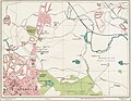 Street Atlas of Birmingham - 1939 - Sheet 02 - West Bromwich (north).jpg 1,000 × 779; 354 KB
-
 Street Atlas of Birmingham - 1939 - Sheet 07 - Handsworth.jpg 1,000 × 773; 579 KB
-
 Swan Pool View - geograph.org.uk - 1650799.jpg 640 × 480; 39 KB
-

-

-
 Trinity Methodist Church, Handsworth - geograph.org.uk - 3552432.jpg 640 × 480; 78 KB
-
 Under the Sun 1 (4598838916).jpg 4,690 × 3,072; 6.25 MB
-
 Under the Sun 1.JPG 2,000 × 3,008; 2.52 MB
-
 Under the Sun 2 (4598223713).jpg 3,840 × 2,826; 5.06 MB
-
 Under the Sun 2.JPG 2,000 × 3,008; 2.65 MB
-
 Under the Sun 3 (4598262765) (2).jpg 2,848 × 4,672; 8.15 MB
-
 Under the Sun 4 (4598851198) (2).jpg 3,168 × 4,752; 7.01 MB
-
 View of Mr Egginton's House near Soho Birmingham - 1775 - artist unknown.png 4,000 × 3,056; 22.25 MB
-
 Westbourne Road - geograph.org.uk - 3552427.jpg 640 × 480; 73 KB
-
 Windermere Road, Handsworth - geograph.org.uk - 5872916.jpg 1,024 × 768; 249 KB
-
 Browns Green Lodge - geograph.org.uk - 199141.jpg 640 × 480; 65 KB
-
 Handsworth Road - geograph.org.uk - 1419843.jpg 640 × 480; 65 KB
-
 Hawthorne House, Handsworth - geograph.org.uk - 199138.jpg 640 × 480; 62 KB
.jpg)


.jpg)

.jpg)
_(14515731673).jpg)


.jpg)
.jpg)
.jpg)
.jpg)


_-_geograph.org.uk_-_3552421.jpg)


.png)


,_Handsworth_-_geograph.org.uk_-_3552433.jpg)


.jpg)


.jpg)

.jpg)

_(2).jpg)
_(2).jpg)


