Category:Hans-Schuster-Hof
Jump to navigation
Jump to search
| Object location | | View all coordinates using: OpenStreetMap |
|---|
house in Trebendorf, Germany .jpg) | |||||
| Upload media | |||||
| Instance of | |||||
|---|---|---|---|---|---|
| Location | Trebendorf, Görlitz, Saxony, Germany | ||||
| Street address |
| ||||
| Heritage designation | |||||
| Inception |
| ||||
 | |||||
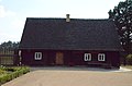
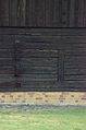
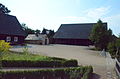
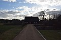
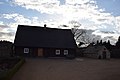
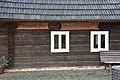
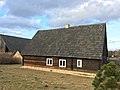
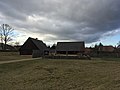
Deutsch: Schrotholzhaus und Backhaus [eines Bauernhofes] in Trebendorf, Dorfstraße 20; um 1850; Backhaus aus Klinker, baugeschichtlich und sozialgeschichtlich von Bedeutung
English: Timber wood farmhouse and bakery house [of a farm] in Trebendorf; around 1905; bakery house made of clinker; of importance for architectural and social history
| (Wikidata) |
Media in category "Hans-Schuster-Hof"
The following 31 files are in this category, out of 31 total.
-
 Hans Schuster-Hof Trebendorf.jpg 2,560 × 1,920; 1.23 MB
-
 Hans-Schuster-Hof, 2015 – DSC 0106.JPG 4,928 × 3,264; 7.98 MB
-
 Hans-Schuster-Hof, 2015 – DSC 0107 retuschiert.jpg 4,928 × 3,264; 4.18 MB
-
 Hans-Schuster-Hof, 2015 – DSC 0107-02.jpg 4,928 × 3,264; 5.76 MB
-
 Hans-Schuster-Hof, 2015 – DSC 0107.JPG 4,928 × 3,264; 8.67 MB
-
 Hans-Schuster-Hof, 2015 – DSC 0108.JPG 4,928 × 3,264; 8.03 MB
-
 Hans-Schuster-Hof, 2015 – DSC 0109.JPG 4,928 × 3,264; 8.07 MB
-
 Hans-Schuster-Hof, 2015 – DSC 0112.JPG 4,928 × 3,264; 7.85 MB
-
 Hans-Schuster-Hof, 2015 – DSC 0113.JPG 3,264 × 4,928; 7.58 MB
-
 Hans-Schuster-Hof, 2015 – DSC 0114.JPG 3,264 × 4,928; 7.51 MB
-
 Hans-Schuster-Hof, 2015 – DSC 0115.JPG 4,928 × 3,264; 7.38 MB
-
 Hans-Schuster-Hof, 2015 – DSC 0116.JPG 4,928 × 3,264; 8.11 MB
-
 Hans-Schuster-Hof, 2015 – DSC 0117.JPG 4,928 × 3,264; 8.05 MB
-
 Hans-Schuster-Hof, 2015 – DSC 0118.JPG 4,928 × 3,264; 8.22 MB
-
 Hans-Schuster-Hof, 2015 – DSC 0119.JPG 4,928 × 3,264; 8.23 MB
-
 Hans-Schuster-Hof, 2015 – DSC 0120.JPG 3,264 × 4,928; 8.17 MB
-
 Hans-Schuster-Hof, 2015 – DSC 0121.JPG 4,928 × 3,264; 8.26 MB
-
 Hans-Schuster-Hof, 2015 – DSC 0122.JPG 4,928 × 3,264; 8.08 MB
-
 Trebendorf, Hans-Schuster-Hof (01).jpg 6,000 × 4,000; 8.72 MB
-
 Trebendorf, Hans-Schuster-Hof (02).jpg 6,000 × 4,000; 8.06 MB
-
 Trebendorf, Hans-Schuster-Hof (03).jpg 6,000 × 4,000; 7.44 MB
-
 Trebendorf, Hans-Schuster-Hof (04).jpg 6,000 × 4,000; 11.58 MB
-
 Trebendorf, Hans-Schuster-Hof (05).jpg 6,000 × 4,000; 12.1 MB
-
 Trebendorf, Hans-Schuster-Hof (06).jpg 6,000 × 4,000; 11.99 MB
-
 Trebendorf, Hans-Schuster-Hof (07).jpg 6,000 × 4,000; 11.77 MB
-
 Trebendorf, Hans-Schuster-Hof (08).jpg 6,000 × 4,000; 8.24 MB
-
 Trebendorf, Hans-Schuster-Hof (09).jpg 6,000 × 4,000; 9.72 MB
-
 Trebendorf, Hans-Schuster-Hof (10).jpg 6,000 × 4,000; 10.61 MB
-
 Trebendorf, Hans-Schuster-Hof (11).jpg 4,032 × 3,024; 3.11 MB
-
 Trebendorf, Hans-Schuster-Hof (12).jpg 4,032 × 3,024; 2.25 MB
-
 Trebendorf, Hans-Schuster-Hof (13).jpg 4,032 × 3,024; 2.42 MB


.jpg)
.jpg)
.jpg)
.jpg)
.jpg)
.jpg)
.jpg)
.jpg)
.jpg)
.jpg)
.jpg)
.jpg)