Category:Harkstead
Jump to navigation
Jump to search
English: Harkstead is a village and civil parish in Suffolk, England. The village is located on the northern bank of the River Stour estuary at Holbrook Bay, and is situated on the Shotley peninsula, around south of Ipswich. It is part of Babergh district.
village in United Kingdom  | |||||
| Upload media | |||||
| Instance of | |||||
|---|---|---|---|---|---|
| Location | Babergh, Suffolk, East of England, England | ||||
 | |||||
Subcategories
This category has the following 3 subcategories, out of 3 total.
Media in category "Harkstead"
The following 200 files are in this category, out of 216 total.
(previous page) (next page)-
 A tree-lined footpath in Suffolk - geograph.org.uk - 4552784.jpg 1,920 × 1,080; 633 KB
-
 Abandoned house outside Harkstead - geograph.org.uk - 1384845.jpg 640 × 480; 80 KB
-
 Above The Stour - geograph.org.uk - 3699480.jpg 1,024 × 768; 189 KB
-
 Across the square to Beaumont Hall - geograph.org.uk - 660645.jpg 480 × 640; 174 KB
-
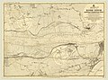 Admiralty Chart No 9 River Stour Harwich to Harkstead Point, Published 1911.jpg 8,280 × 6,132; 7.77 MB
-
 Algae on the foreshore - geograph.org.uk - 2553532.jpg 3,648 × 2,736; 3.2 MB
-
 Arable field near Beaumont Hall - geograph.org.uk - 2618321.jpg 3,648 × 2,255; 2.11 MB
-
 Arable field near Nether Hall - geograph.org.uk - 2553560.jpg 3,648 × 2,255; 3.35 MB
-
 Armed Trespassers Will Be Prosecuted - geograph.org.uk - 3699126.jpg 1,024 × 768; 220 KB
-
 Barley field - geograph.org.uk - 5991655.jpg 1,024 × 681; 140 KB
-
 Barn, Lower Farm - geograph.org.uk - 5980103.jpg 1,024 × 681; 170 KB
-
 Beaumont Hall farm - geograph.org.uk - 4873506.jpg 3,264 × 2,176; 689 KB
-
 Brick Kiln Lane - geograph.org.uk - 5980094.jpg 1,024 × 681; 254 KB
-
 Brick Kiln Lane - geograph.org.uk - 5980109.jpg 1,024 × 681; 298 KB
-
 Brick Kiln Lane passing Lower Farm - geograph.org.uk - 5980100.jpg 1,024 × 681; 204 KB
-
 Brick Kiln Rd - geograph.org.uk - 5985191.jpg 1,024 × 681; 238 KB
-
 Brick Kiln Rd - geograph.org.uk - 5985192.jpg 1,024 × 681; 264 KB
-
 Brick Kiln Rd - geograph.org.uk - 5985196.jpg 1,024 × 681; 253 KB
-
 Brick Kiln Rd - geograph.org.uk - 5985218.jpg 1,024 × 681; 166 KB
-
 Brick Kiln Rd - geograph.org.uk - 5985221.jpg 1,024 × 681; 164 KB
-
 Brick Kiln Rd - geograph.org.uk - 5985225.jpg 1,024 × 681; 171 KB
-
 Brick Kiln Rd - geograph.org.uk - 5985228.jpg 1,024 × 681; 159 KB
-
 Brick Kiln Rd - geograph.org.uk - 5985231.jpg 1,024 × 871; 203 KB
-
 Brick Kiln Rd, Ling's Lane junction - geograph.org.uk - 5985232.jpg 1,024 × 681; 144 KB
-
 By Brick Kiln Rd - geograph.org.uk - 5985193.jpg 1,024 × 681; 160 KB
-
 Cabin cruiser on the River Stour - geograph.org.uk - 5366580.jpg 640 × 480; 188 KB
-
 Church Lane - geograph.org.uk - 5991662.jpg 1,024 × 681; 198 KB
-
 Church of St Mary - geograph.org.uk - 5985250.jpg 1,024 × 681; 222 KB
-
 Church of St Mary - geograph.org.uk - 5985257.jpg 1,024 × 681; 243 KB
-
 Church of St Mary - geograph.org.uk - 5985258.jpg 1,024 × 681; 185 KB
-
 Church of St Mary - geograph.org.uk - 5985259.jpg 1,024 × 681; 223 KB
-
 Church of St Mary - geograph.org.uk - 5985262.jpg 1,024 × 681; 202 KB
-
 Church of St Mary - geograph.org.uk - 5985263.jpg 681 × 1,024; 255 KB
-
 Country east of Harkstead - geograph.org.uk - 5611507.jpg 640 × 480; 102 KB
-
 Crop of potatoes - geograph.org.uk - 5993907.jpg 1,024 × 681; 257 KB
-
 Crops by Brick Kiln Lane - geograph.org.uk - 5980111.jpg 1,024 × 681; 187 KB
-
 Crops by Brick Kiln Lane - geograph.org.uk - 5980113.jpg 1,024 × 681; 170 KB
-
 Curving shoreline near Harkstead - geograph.org.uk - 1283018.jpg 640 × 451; 112 KB
-
 Cutting the hay - geograph.org.uk - 2553522.jpg 2,809 × 1,736; 1.73 MB
-

-
 Entering Harkstead - geograph.org.uk - 5991659.jpg 1,024 × 681; 208 KB
-
 Entering Harkstead - geograph.org.uk - 5993923.jpg 1,024 × 681; 241 KB
-
 Eroding Cliff detail - geograph.org.uk - 2553117.jpg 1,500 × 1,500; 1.01 MB
-
 Eroding cliffs - geograph.org.uk - 2553108.jpg 3,648 × 2,736; 3.28 MB
-
 Estuary shoreline, River Stour - geograph.org.uk - 1283068.jpg 640 × 518; 168 KB
-
 Fallen tree in The Grove - geograph.org.uk - 721914.jpg 480 × 640; 164 KB
-
 Farm buildings outside Harkstead - geograph.org.uk - 1384842.jpg 640 × 480; 56 KB
-
 Farm machinery by Brick Kiln Lane - geograph.org.uk - 5980107.jpg 1,024 × 681; 143 KB
-
 Farm track near Beaumont Hall - geograph.org.uk - 1384846.jpg 640 × 480; 68 KB
-
 Farmyard near Beaumont Hall - geograph.org.uk - 2618317.jpg 2,982 × 1,843; 1.44 MB
-
 Field by Brick Kiln Lane - geograph.org.uk - 5980095.jpg 1,024 × 681; 191 KB
-
 Field corner north of Lovers Lane - geograph.org.uk - 5611377.jpg 640 × 480; 175 KB
-
 Field near Lower Farm - geograph.org.uk - 5611367.jpg 640 × 428; 117 KB
-
 Field near Red House Farm - geograph.org.uk - 5980091.jpg 1,024 × 681; 138 KB
-
 Field near Vale Farm - geograph.org.uk - 2553139.jpg 3,648 × 2,736; 2.71 MB
-
 Field of Wheat - geograph.org.uk - 5980096.jpg 1,024 × 681; 161 KB
-
 Fields and ditches - geograph.org.uk - 5611559.jpg 640 × 480; 135 KB
-

-
 Fish Pond Hill - geograph.org.uk - 5985245.jpg 1,024 × 681; 215 KB
-
 Footbridge over ditch - geograph.org.uk - 5991627.jpg 1,024 × 681; 262 KB
-
 Footpath - geograph.org.uk - 3699098.jpg 1,024 × 768; 185 KB
-
 Footpath - geograph.org.uk - 3699265.jpg 1,024 × 768; 191 KB
-
 Footpath - geograph.org.uk - 3699282.jpg 1,024 × 768; 310 KB
-
 Footpath along field boundary - geograph.org.uk - 5991624.jpg 1,024 × 681; 196 KB
-
 Footpath along field boundary - geograph.org.uk - 5993918.jpg 1,024 × 681; 239 KB
-
 Footpath along field edge - geograph.org.uk - 5993919.jpg 1,024 × 681; 250 KB
-
 Footpath along the western edge of Rence Park - geograph.org.uk - 6091466.jpg 5,474 × 3,649; 4.51 MB
-
 Footpath at Rence park - geograph.org.uk - 4422597.jpg 1,024 × 768; 617 KB
-
 Footpath crossing rape field - geograph.org.uk - 5991629.jpg 1,024 × 681; 180 KB
-
 Footpath off Brick Kiln Lane - geograph.org.uk - 5980114.jpg 1,024 × 681; 248 KB
-
 Footpath off Rectory Rd - geograph.org.uk - 5991608.jpg 1,024 × 681; 228 KB
-
 Footpath off Rectory Rd - geograph.org.uk - 5991617.jpg 1,024 × 681; 312 KB
-
 Footpath over arable land, near Nether Hall, Harkstead - geograph.org.uk - 4464587.jpg 3,648 × 2,736; 2.48 MB
-
 Footpath to Harkstead - geograph.org.uk - 5993908.jpg 1,024 × 681; 323 KB
-
 Footpath to Harkstead - geograph.org.uk - 5993914.jpg 1,024 × 681; 306 KB
-
 Footpath With A View - geograph.org.uk - 3699460.jpg 1,024 × 768; 191 KB
-
 Footpath, oilseed rape field - geograph.org.uk - 5991637.jpg 1,024 × 681; 196 KB
-
 Gone to seed - geograph.org.uk - 5993917.jpg 1,024 × 681; 167 KB
-
 Graves, Church of St Mary - geograph.org.uk - 5985252.jpg 1,024 × 681; 245 KB
-
 Grove Lane - geograph.org.uk - 1384853.jpg 640 × 480; 50 KB
-

-
 Harkstead Hall Farm - geograph.org.uk - 5985233.jpg 1,024 × 681; 157 KB
-
 Harkstead Hall Farm - geograph.org.uk - 5985234.jpg 1,024 × 681; 214 KB
-
 Harkstead snow fields - geograph.org.uk - 2210286.jpg 2,692 × 2,021; 1.18 MB
-
 Harkstead Village Sign - geograph.org.uk - 5991672.jpg 681 × 1,024; 220 KB
-
 Hawthorn clinging on to the cliff - geograph.org.uk - 1283033.jpg 640 × 571; 225 KB
-
 Haystack near Rence Park Farm - geograph.org.uk - 1282740.jpg 640 × 470; 115 KB
-
 Hedge, field and wood - geograph.org.uk - 1282752.jpg 640 × 406; 93 KB
-
 Holbrook Bay - geograph.org.uk - 2210297.jpg 2,816 × 2,112; 2.83 MB
-
 House near Harkstead Church - geograph.org.uk - 1282816.jpg 640 × 453; 104 KB
-
 House opposite the church - geograph.org.uk - 5985261.jpg 1,024 × 681; 187 KB
-
 House, Harkstead - geograph.org.uk - 5991661.jpg 1,024 × 681; 189 KB
-
 Impressive farm machinery - geograph.org.uk - 5611374.jpg 640 × 428; 79 KB
-
 Ipswich Rd - geograph.org.uk - 5980092.jpg 1,024 × 681; 196 KB
-
 Ipswich Rd - geograph.org.uk - 5991686.jpg 1,024 × 681; 206 KB
-
 Ipswich Rd - geograph.org.uk - 5991689.jpg 1,024 × 681; 167 KB
-
 Ipswich Rd - geograph.org.uk - 5991691.jpg 1,024 × 681; 197 KB
-
 Ipswich Rd - geograph.org.uk - 5991696.jpg 1,024 × 681; 175 KB
-
 Ipswich Rd - geograph.org.uk - 5991697.jpg 1,024 × 681; 269 KB
-
 Ipswich Rd - geograph.org.uk - 5991803.jpg 1,024 × 681; 200 KB
-
 Junction near church - geograph.org.uk - 2513731.jpg 3,648 × 2,736; 2.98 MB
-
 Kayaks on the River Stour - geograph.org.uk - 5366578.jpg 640 × 480; 226 KB
-
 Knight's Farm - geograph.org.uk - 1384850.jpg 640 × 461; 77 KB
-
 Land sloping down to the river - geograph.org.uk - 4422591.jpg 1,024 × 768; 225 KB
-
 Ling's Lane - geograph.org.uk - 5985237.jpg 1,024 × 681; 191 KB
-
 Lone oak tree on Lower Houses Road - geograph.org.uk - 6109575.jpg 6,000 × 4,000; 5.58 MB
-
 Looking across Ling Lane - geograph.org.uk - 1432934.jpg 640 × 480; 85 KB
-
 Looking along the shoreline - geograph.org.uk - 1283019.jpg 640 × 448; 81 KB
-
 Looking east from Harkstead beach - geograph.org.uk - 2553552.jpg 3,648 × 2,255; 2.07 MB
-
 Looking over a field towards Holbrook Bay - geograph.org.uk - 2553132.jpg 3,648 × 2,736; 2.21 MB
-
 Looking towards Harkstead - geograph.org.uk - 2553583.jpg 3,648 × 2,255; 1.89 MB
-
 Looking towards Holbrook Bay - geograph.org.uk - 2553513.jpg 3,027 × 1,871; 1.92 MB
-
 Looking towards Rence Park Farm - geograph.org.uk - 2553209.jpg 2,700 × 1,688; 1.43 MB
-
 Losing the battle - geograph.org.uk - 722341.jpg 479 × 640; 93 KB
-
 Lover's Lane - geograph.org.uk - 5985197.jpg 1,024 × 681; 256 KB
-
 Lower Farm - geograph.org.uk - 5980097.jpg 1,024 × 681; 208 KB
-
 Lower Houses Rd - geograph.org.uk - 5985240.jpg 1,024 × 681; 144 KB
-
 Lower Houses Road - geograph.org.uk - 1282800.jpg 640 × 461; 136 KB
-
 Lower Houses Road, Harkstead - geograph.org.uk - 6109894.jpg 6,000 × 4,000; 6.59 MB
-
 Map of Harkstead, OS 1946.png 231 × 151; 64 KB
-
 Miniature cliff by the Stour - geograph.org.uk - 1283031.jpg 640 × 445; 129 KB
-
 Narrow Lane - geograph.org.uk - 3699273.jpg 1,024 × 768; 221 KB
-
 Near the end of Grove Lane - geograph.org.uk - 1432917.jpg 640 × 404; 70 KB
-
 Needle Corner, Harkstead - geograph.org.uk - 4029376.jpg 640 × 427; 65 KB
-
 No through Road - geograph.org.uk - 5991685.jpg 1,024 × 681; 228 KB
-
 Northern bank of the River Stour - geograph.org.uk - 1283061.jpg 640 × 429; 92 KB
-
 Oilseed rape - geograph.org.uk - 5985242.jpg 1,024 × 681; 161 KB
-
 Oilseed rape - geograph.org.uk - 5985277.jpg 1,024 × 681; 234 KB
-
 Oilseed rape - geograph.org.uk - 5991633.jpg 1,024 × 681; 216 KB
-
 Oilseed rape - geograph.org.uk - 5991634.jpg 1,024 × 681; 167 KB
-
 Oilseed rape, with Hospital school beyond - geograph.org.uk - 5993921.jpg 1,024 × 681; 107 KB
-
 Old Hall Cottages - geograph.org.uk - 5985235.jpg 1,024 × 680; 134 KB
-
 Old Hall Cottages - geograph.org.uk - 5985247.jpg 1,024 × 681; 172 KB
-
 Old oak tree on Lower Houses Road - geograph.org.uk - 6109886.jpg 6,000 × 4,000; 5.59 MB
-
 Old tree trunk - geograph.org.uk - 717630.jpg 640 × 422; 76 KB
-
 Old trees along Ipswich Road, Harkstead - geograph.org.uk - 6109214.jpg 6,000 × 4,000; 6.32 MB
-
 On Rectory Rd - geograph.org.uk - 5985268.jpg 1,024 × 681; 225 KB
-
 On Rectory Rd - geograph.org.uk - 5985273.jpg 1,024 × 681; 202 KB
-
 Overhanging tree - geograph.org.uk - 722352.jpg 640 × 434; 131 KB
-
 Peacocks, Rectory Rd - geograph.org.uk - 5985266.jpg 1,024 × 681; 255 KB
-
 Ploughed fields on the northern edge of Harkstead - geograph.org.uk - 6109231.jpg 6,000 × 4,000; 6.28 MB
-
 Polly's Cottage - geograph.org.uk - 5991666.jpg 1,024 × 681; 140 KB
-
 Postbox - geograph.org.uk - 3699141.jpg 768 × 1,024; 289 KB
-
 Postbox and churchyard, Harkstead - geograph.org.uk - 6109547.jpg 6,000 × 4,000; 6.83 MB
-
 Potato crop - geograph.org.uk - 5985190.jpg 1,024 × 681; 162 KB
-
 Potato crop - geograph.org.uk - 5991806.jpg 1,024 × 681; 198 KB
-
 Pylons crossing Harkstead Road - geograph.org.uk - 6091438.jpg 5,779 × 3,853; 2.75 MB
-
 Recently coppiced woodland at Rence Park - geograph.org.uk - 6091442.jpg 6,000 × 4,000; 6.77 MB
-
 Rectory Cottage - geograph.org.uk - 5991606.jpg 1,024 × 681; 214 KB
-
 Rectory Rd - geograph.org.uk - 5985264.jpg 1,024 × 681; 236 KB
-
 Rectory Rd - geograph.org.uk - 5985270.jpg 1,024 × 681; 282 KB
-
 Rectory Rd - geograph.org.uk - 5985274.jpg 1,024 × 681; 276 KB
-
 Rectory Rd - geograph.org.uk - 5985278.jpg 1,024 × 681; 264 KB
-
 Rectory Rd - geograph.org.uk - 5991610.jpg 1,024 × 681; 184 KB
-
 Red House Farm - geograph.org.uk - 1384839.jpg 640 × 480; 90 KB
-
 Rence Park Cottages viewed from Grove Lane - geograph.org.uk - 6091455.jpg 4,628 × 3,085; 2.55 MB
-
 Ripening barley - geograph.org.uk - 5991620.jpg 1,024 × 681; 211 KB
-
 Ripening barley - geograph.org.uk - 5991651.jpg 1,024 × 681; 178 KB
-
 Ripening barley - geograph.org.uk - 5991656.jpg 1,024 × 681; 131 KB
-
 Ripening crop - geograph.org.uk - 5991802.jpg 1,024 × 681; 130 KB
-
 River Stour - geograph.org.uk - 3699439.jpg 1,024 × 768; 136 KB
-
 River Stour flotsam - geograph.org.uk - 722373.jpg 640 × 427; 96 KB
-
 River View Rd - geograph.org.uk - 5991694.jpg 1,024 × 681; 160 KB
-
 Riverbank And Sign - geograph.org.uk - 3699114.jpg 1,024 × 768; 310 KB
-
 Riverside - geograph.org.uk - 3699469.jpg 1,024 × 768; 220 KB
-
 Rose Farm - geograph.org.uk - 5991702.jpg 1,024 × 681; 193 KB
-
 Row of trees at Harkstead Hall Farm - geograph.org.uk - 6109563.jpg 6,000 × 4,000; 6.63 MB
-
 Royal Hospital School - geograph.org.uk - 5366579.jpg 640 × 480; 192 KB
-
 Shore Lane in the spring - geograph.org.uk - 1282870.jpg 640 × 505; 152 KB
-
 Shoreline and River Stour estuary - geograph.org.uk - 1283038.jpg 640 × 435; 95 KB
-
 Sparrow Hall, abandoned listed building - geograph.org.uk - 2513729.jpg 3,648 × 2,736; 3.35 MB
-
 Spraying the emerging crop - geograph.org.uk - 4422594.jpg 1,024 × 768; 295 KB
-
 St. Mary's church, Harkstead - geograph.org.uk - 6109554.jpg 6,000 × 4,000; 6.29 MB
-
 Stile Through Hedge - geograph.org.uk - 3699324.jpg 768 × 1,024; 293 KB
-

-
 The aptly named Slushy Lane, Harkstead - geograph.org.uk - 6109219.jpg 6,000 × 4,000; 6.29 MB
-
 The Bakers Arms - geograph.org.uk - 5991669.jpg 1,024 × 681; 160 KB
-
 The Old Post Office - geograph.org.uk - 5991675.jpg 1,024 × 681; 216 KB
-
 The River Stour - geograph.org.uk - 3699103.jpg 1,024 × 768; 193 KB
-
 The road to Harkstead - geograph.org.uk - 1384840.jpg 640 × 480; 101 KB
-
 The Street - geograph.org.uk - 5991640.jpg 1,024 × 681; 237 KB
-
 The Street - geograph.org.uk - 5991643.jpg 1,024 × 681; 174 KB
-
 The Street - geograph.org.uk - 5991645.jpg 1,024 × 681; 247 KB
-

-
 The Vale Farm - geograph.org.uk - 5611365.jpg 640 × 428; 104 KB
-
 Toadflax by farm track - geograph.org.uk - 1432913.jpg 640 × 568; 150 KB
-
 Track at Rose Farm - geograph.org.uk - 5991801.jpg 1,024 × 681; 248 KB
-
 Track near Sparrow Hall - geograph.org.uk - 2513833.jpg 3,648 × 2,736; 2.66 MB
-
 Track off Ipswich Rd - geograph.org.uk - 5991804.jpg 1,024 × 681; 240 KB
-
 Track to Nether Hall - geograph.org.uk - 717632.jpg 640 × 427; 86 KB
-
 Track to Rence Park Farm - geograph.org.uk - 4422595.jpg 1,024 × 768; 282 KB
-
 Track to The Vale Farm - geograph.org.uk - 5985226.jpg 1,024 × 681; 228 KB
-
 Track towards Rence Park Farm - geograph.org.uk - 6091492.jpg 6,000 × 4,000; 7.15 MB
-
 Unmarked Footpath - geograph.org.uk - 3699309.jpg 1,024 × 768; 234 KB
-
 Upper Grove, Harkstead - geograph.org.uk - 2553218.jpg 3,648 × 2,736; 4.93 MB
-
 View towards Harkstead - geograph.org.uk - 1283028.jpg 640 × 597; 98 KB
-
 View towards Harkstead village - geograph.org.uk - 1282878.jpg 640 × 437; 97 KB
-
 Wheat field - geograph.org.uk - 5991699.jpg 1,024 × 681; 200 KB
-
 Wheat field by Rectory Rd - geograph.org.uk - 5991615.jpg 1,024 × 681; 176 KB
-
 Wires over the fields, Harkstead - geograph.org.uk - 2553193.jpg 2,483 × 3,310; 1.28 MB


