Category:Harrow
Jump to navigation
Jump to search
large suburban town in Greater London, England  | |||||
| Upload media | |||||
| Instance of | |||||
|---|---|---|---|---|---|
| Location | London Borough of Harrow, Greater London, London, England | ||||
| Different from | |||||
 | |||||
The HA postcode area, also known as the Harrow postcode area, is a group of ten postcode areas in England which are subdivisions of seven post towns. Most cover parts of north west London, although HA6 also covers a small part of Hertfordshire.
Subcategories
This category has the following 15 subcategories, out of 15 total.
B
C
H
- Harrow bus station (22 F)
- Harrow Civic Centre (4 F)
- Harrow Crown Court (4 F)
- Harrow High School (5 F)
M
P
S
Media in category "Harrow"
The following 111 files are in this category, out of 111 total.
-
 1, High Street, Harrow.jpg 1,936 × 2,592; 1.62 MB
-
 12, Norman Crescent, Pinner (6028014933).jpg 1,744 × 1,308; 607 KB
-
 Roscoe L&BR(1839) p069 - Harrow on the Hill.jpg 2,128 × 1,317; 989 KB
-
 1904 Church.jpg 1,920 × 1,280; 888 KB
-
 1985-07-07 Leeds - Jim Page.jpg 1,728 × 1,196; 444 KB
-
 20190624 072657000 iOS.jpg 1,024 × 768; 114 KB
-
 20190624 072659000 iOS.jpg 1,600 × 1,200; 201 KB
-
 20190624 072710000 iOS 1.jpg 1,024 × 768; 65 KB
-
 31-35 West Street, Harrow.jpg 3,648 × 2,736; 4.07 MB
-
 57 of '(Our own country. Descriptive, historical, pictorial.)' (11245520354).jpg 1,883 × 1,561; 798 KB
-
 89 Kenton Lane, Kenton (6108529879).jpg 1,255 × 1,009; 203 KB
-

-
 Au Morandarte Flickr London Sovereign VH5 on Route 183, Harrow Town Centre (14800442165).jpg 3,888 × 2,592; 4.04 MB
-
 Bessborough Road Harrow.jpg 2,304 × 1,728; 987 KB
-
 BMI The Clementine Churchill Hospital - panoramio.jpg 2,048 × 1,536; 408 KB
-
 Bouverie Road, West Harrow - geograph.org.uk - 2213693.jpg 640 × 480; 51 KB
-
 Bradstowe House front.jpg 1,862 × 1,186; 1.15 MB
-
 Bradstowe House seen from the roundabout.jpg 1,850 × 1,166; 1.08 MB
-
 Brockley Hill sanatorium for Tuberculosis Wellcome L0013964.jpg 1,614 × 1,190; 934 KB
-
 Buses, Clarendon Road and College Road.jpg 1,920 × 1,280; 1.2 MB
-
 Butler Road, Harrow - geograph.org.uk - 4648272.jpg 640 × 480; 75 KB
-
 Chandos Elephant (616257110).jpg 1,280 × 960; 374 KB
-
 Christchurch Avenue, Harrow - geograph.org.uk - 5285181.jpg 3,264 × 2,448; 1.89 MB
-
 Christchurch Avenue, Harrow - geograph.org.uk - 5285183.jpg 3,170 × 2,318; 2.21 MB
-
 Church of St Joseph from E.png 2,915 × 4,620; 10.7 MB
-
 Church of St Joseph from SE.png 2,634 × 2,497; 5.92 MB
-
 Clarendon Road King's House & Queen's House.jpg 1,872 × 1,204; 1.2 MB
-
 Cricket Pavilion - geograph.org.uk - 1409797.jpg 640 × 480; 91 KB
-
 Debenhams in Harrow shortly before its final closure (1).jpg 5,504 × 3,096; 6.43 MB
-
 Debenhams in Harrow shortly before its final closure (2).jpg 5,200 × 2,920; 1.55 MB
-
 Department store, Harrow - geograph.org.uk - 99134.jpg 494 × 347; 178 KB
-
 Drury Road, West Harrow - geograph.org.uk - 2213701.jpg 4,320 × 3,240; 4.07 MB
-
 Greenhill Way, Harrow - geograph.org.uk - 1936337.jpg 959 × 1,280; 165 KB
-
 Grove Hill, Harrow.jpg 4,160 × 3,120; 4.32 MB
-
 Grythengen foto høst 51.jpg 6,000 × 4,000; 14.39 MB
-
 H9 on Headstone Drive - geograph.org.uk - 3920397.jpg 1,600 × 1,080; 460 KB
-
 Harrow - College Road (north side) - geograph.org.uk - 2880888.jpg 640 × 480; 179 KB
-
 Harrow - College Road (south side) - geograph.org.uk - 2880899.jpg 640 × 480; 145 KB
-
 Harrow 15 mile radius.png 1,114 × 1,080; 135 KB
-
 Harrow Bus Station 2.jpg 4,026 × 3,002; 2.79 MB
-
 Harrow Era Mix.jpg 4,000 × 3,000; 1.93 MB
-
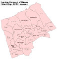 Harrow London UK labelled ward map 2002.svg 1,116 × 1,169; 116 KB
-
 Harrow Square blocks.jpg 1,886 × 1,226; 1.29 MB
-
 Harrow View, Harrow - geograph.org.uk - 2229809.jpg 1,600 × 1,200; 642 KB
-
 Harrow, St George's Shopping and Leisure - geograph.org.uk - 528187.jpg 640 × 482; 146 KB
-

-
 Havelock Place.jpg 1,920 × 1,280; 1.3 MB
-
 Headstone, St George's Hall - geograph.org.uk - 760353.jpg 640 × 480; 84 KB
-
 Heathfield School, Pinner.jpg 1,944 × 1,296; 390 KB
-
 Henry Edridge - View of Harrow Church - B1975.4.1910 - Yale Center for British Art.jpg 1,920 × 1,369; 333 KB
-
 High Street, Pinner (6606212977).jpg 1,875 × 1,470; 556 KB
-
 House at Harrow.jpg 2,348 × 1,482; 531 KB
-
 Hygeia Building and King's House, Harrow.jpg 1,107 × 1,423; 903 KB
-
 Hygeia building sculpture 1.jpg 822 × 1,095; 571 KB
-
 Hygeia building sculpture 2.jpg 594 × 786; 283 KB
-
 Jenga House, Harrow.jpg 3,024 × 4,032; 2.18 MB
-
 King's House Harrow.jpg 1,280 × 1,920; 905 KB
-
 Kingshill Drive at the junction of Christchurch Avenue - geograph.org.uk - 5285180.jpg 3,264 × 2,448; 1.9 MB
-
 Kingshill Drive, Harrow - geograph.org.uk - 5285184.jpg 2,448 × 3,264; 4.78 MB
-
 Leabank Road, Harrow - geograph.org.uk - 2280083.jpg 2,560 × 1,920; 1.18 MB
-
Learning Journeys - A Teachers Perspective.ogv 11 min 47 s, 176 × 144; 8.84 MB
-
-

-
 Lowlands Road, Harrow - geograph.org.uk - 2154682.jpg 640 × 480; 145 KB
-
 Lowlands Road.jpg 1,920 × 1,280; 1.32 MB
-
 Memorial and civic buildings, Harrow - geograph.org.uk - 4782093.jpg 640 × 480; 114 KB
-
 Minigolf at Northwick Park - geograph.org.uk - 651869.jpg 640 × 480; 106 KB
-
 Montage de dent.png 488 × 522; 93 KB
-
 Moretons, High Street, Harrow.jpg 2,592 × 1,936; 1.48 MB
-
 NatWest Harrow Grade II listed building.jpg 1,858 × 1,180; 1.36 MB
-

-
 Northwick Park driving range.jpg 1,600 × 1,200; 745 KB
-
 Northwick Park, London Borough of Harrow, HA0 HA9 (1235208970).jpg 1,280 × 960; 307 KB
-
 Northwick Park.jpg 2,304 × 1,728; 830 KB
-
 Photo The use of the harrows to plant the crops 1967 - Touring Club Italiano 1.2741.jpg 2,832 × 3,525; 1.13 MB
-
 Pinner Road at the junction of Southfield Park - geograph.org.uk - 3093613.jpg 1,600 × 1,200; 596 KB
-
 Pinner Road at the junction of The Gardens - geograph.org.uk - 4201294.jpg 2,304 × 1,728; 618 KB
-
 Pinner Road, Harrow - geograph.org.uk - 4201340.jpg 2,299 × 1,646; 638 KB
-
 Pinner View, Harrow - geograph.org.uk - 4201455.jpg 2,304 × 1,728; 833 KB
-
 Pinner View, Harrow - geograph.org.uk - 4201491.jpg 2,304 × 1,728; 659 KB
-
 Pinner Wood School (6600746033).jpg 1,926 × 1,198; 587 KB
-
 Robert Hills - A Farm at Harrow - B1975.4.1252 - Yale Center for British Art.jpg 1,920 × 1,385; 267 KB
-
 Roxborough Road - geograph.org.uk - 441138.jpg 640 × 480; 96 KB
-
 Roxborough Road - geograph.org.uk - 441140.jpg 640 × 480; 98 KB
-
 Roxeth Green Avenue, Harrow - geograph.org.uk - 3751089.jpg 2,304 × 1,728; 832 KB
-
 Royal Oak Harrow.jpg 3,968 × 2,232; 3.94 MB
-
 Safari Cinema.jpg 1,425 × 1,084; 187 KB
-
 Skipping Katie cropped.jpg 1,215 × 1,707; 240 KB
-
 Skipping Katie.jpg 1,222 × 1,882; 1.1 MB
-

-
 St Ann's centre frontage.jpg 1,920 × 1,280; 1.62 MB
-
 St Ann's Road, Harrow 2.jpg 2,048 × 1,536; 534 KB
-
 St Ann's Road, Harrow.jpg 2,048 × 1,536; 629 KB
-
 St Anns Road, Harrow - geograph.org.uk - 2284258.jpg 4,320 × 3,240; 4.36 MB
-
 St Anns Road, Harrow - geograph.org.uk - 2284262.jpg 4,320 × 3,240; 3.98 MB
-
 St Anns Road, Harrow.jpg 4,071 × 3,120; 4.59 MB
-
 St George's Shopping Centre - geograph.org.uk - 440215.jpg 640 × 480; 76 KB
-
 Stanmore, Culver Grove - geograph.org.uk - 477916.jpg 640 × 480; 90 KB
-
 Station Road, Harrow.jpg 4,160 × 3,120; 3.83 MB
-
 Tharun Mohan Train studio.jpg 5,312 × 2,988; 4.47 MB
-
 Time Building.jpg 760 × 647; 273 KB
-
 University of Westminster, Harrow.jpg 1,484 × 1,033; 212 KB
-

-
 Vaughan Road, Harrow - geograph.org.uk - 4648267.jpg 640 × 480; 77 KB
-
 Vaughan Road, West Harrow - geograph.org.uk - 2213697.jpg 640 × 480; 56 KB
-
 Victor Road, Harrow - geograph.org.uk - 4201333.jpg 2,304 × 1,728; 850 KB
-
 Wax Well, Pinner, Middlesex (3970313444).jpg 1,744 × 1,308; 923 KB
-
 Wealdstone Brook in Kenton - geograph.org.uk - 477324.jpg 640 × 480; 157 KB
-
 William Perkin's Grave, Christchurch, Harrow.jpg 1,936 × 2,592; 4.39 MB
-
 Wilson Gardens - the southern end - geograph.org.uk - 2880838.jpg 640 × 480; 165 KB
-
 Wilson Gardens, Harrow - geograph.org.uk - 4648279.jpg 640 × 480; 77 KB

.jpg)
_p069_-_Harrow_on_the_Hill.jpg)


%27_(11245520354).jpg)
.jpg)
.jpg)
.jpg)


.jpg)


.jpg)
.jpg)


_-_geograph.org.uk_-_2880888.jpg)
_-_geograph.org.uk_-_2880899.jpg)


.jpg)


.jpg)


.jpg)


.jpg)


