Category:Hartley's sidings bridge
Jump to navigation
Jump to search
| Object location | | View all coordinates using: OpenStreetMap |
|---|
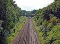
This footbridge, adjacent to the former Hartley's jam factory, is built on the abutments of the former intersection bridge between the Lancashire and Yorkshire Railway and North Liverpool Extension Line of Cheshire Lines Committee. It numbered WJK/67 and is 32.42 miles from Manchester Victoria.
Media in category "Hartley's sidings bridge"
The following 7 files are in this category, out of 7 total.
-
 Hartley's sidings bridge 1.jpg 4,744 × 3,754; 10.85 MB
-
 Hartley's sidings bridge 2.jpg 4,986 × 3,714; 11.14 MB
-
 Hartleys sidings bridge map.jpg 5,152 × 3,864; 10.05 MB
-
 Hartleys sidings diagram.jpg 1,145 × 645; 160 KB
-
 Long Lane bridge from Hartley's sidings bridge.jpg 5,112 × 3,762; 12.1 MB
-
 Pipeline bridge from Hartley's sidings bridge.jpg 4,896 × 3,588; 11.32 MB
-
 View west from Long Lane bridge.jpg 3,462 × 5,198; 18.99 MB


