Category:Hastings Line
Jump to navigation
Jump to search
English: The Hastings Line is a railway line in Kent and East Sussex linking Hastings with the main town of Tunbridge Wells, and from there into London via Sevenoaks.
railway line in Kent and East Sussex, England  | |||||
| Upload media | |||||
| Instance of |
| ||||
|---|---|---|---|---|---|
| Part of |
| ||||
| Location |
| ||||
| Owned by | |||||
| Operator | |||||
| Date of official opening |
| ||||
| Length |
| ||||
| Terminus |
| ||||
| |||||
Subcategories
This category has the following 18 subcategories, out of 18 total.
B
- Battle railway station (39 F)
- Bopeep Junction (10 F)
C
- Crowhurst railway station (52 F)
E
- Etchingham railway station (25 F)
F
- Frant railway station (15 F)
G
- Grove Hill Tunnel (9 F)
H
- High Brooms railway station (209 F)
R
- Robertsbridge railway station (87 F)
S
- Stonegate railway station (37 F)
T
- Tunbridge Wells Tunnel (5 F)
W
- Wadhurst Tunnel (1 F)
Media in category "Hastings Line"
The following 103 files are in this category, out of 103 total.
-
 1066 ticket back.jpg 900 × 666; 171 KB
-
 1066 ticket front.jpg 906 × 672; 176 KB
-
 395014 Approaches Hastings Tunnel 2015-01-30.jpg 4,928 × 3,264; 4.9 MB
-
 A railway cutting in Snape Wood - geograph.org.uk - 1734012.jpg 640 × 451; 109 KB
-
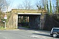
 Bridge over the London to Hastings line - geograph.org.uk - 1724043.jpg 640 × 430; 141 KB
-
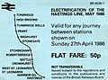
 Electrification of the Hastings to Tonbridge Railway. April 1986.jpg 936 × 700; 190 KB
-
 Footbridge over the railway - geograph.org.uk - 2816736.jpg 640 × 430; 87 KB
-
 Footbridge over the railway line - geograph.org.uk - 2119169.jpg 640 × 430; 158 KB
-
 Gates to the Hastings line - geograph.org.uk - 5131085.jpg 640 × 426; 91 KB
-
 Hastings Line - geograph.org.uk - 2481211.jpg 640 × 315; 84 KB
-
 Hastings Line - geograph.org.uk - 4052451.jpg 640 × 430; 123 KB
-
 Hastings Line - geograph.org.uk - 4052454.jpg 640 × 430; 114 KB
-
 Hastings Line - geograph.org.uk - 4281476.jpg 640 × 430; 101 KB
-
 Hastings line - geograph.org.uk - 4615007.jpg 640 × 426; 105 KB
-
 Hastings Line - geograph.org.uk - 4626159.jpg 640 × 426; 105 KB
-
 Hastings Line - geograph.org.uk - 4853338.jpg 640 × 426; 79 KB
-
 Hastings Line - geograph.org.uk - 5190810.jpg 640 × 473; 107 KB
-
 Hastings Line - geograph.org.uk - 5290788.jpg 640 × 426; 118 KB
-
 Hastings Line - geograph.org.uk - 5290793.jpg 640 × 426; 90 KB
-
 Hastings Line - geograph.org.uk - 5339995.jpg 640 × 426; 95 KB
-
 Hastings Line - geograph.org.uk - 5388298.jpg 640 × 426; 84 KB
-
 Hastings Line - geograph.org.uk - 5656659.jpg 640 × 426; 101 KB
-
 Hastings Line - geograph.org.uk - 5727726.jpg 640 × 426; 70 KB
-
 Hastings Line - geograph.org.uk - 6039558.jpg 1,024 × 681; 215 KB
-
 Hastings line looking north - geograph.org.uk - 2331781.jpg 640 × 430; 91 KB
-
 Hastings line looking south - geograph.org.uk - 2331780.jpg 640 × 430; 81 KB
-

-
 Hastings line.png 2,421 × 2,014; 3.41 MB
-
 Level Crossing, Quarry Woods - geograph.org.uk - 1316087.jpg 640 × 430; 113 KB
-
 Line to High Brooms - geograph.org.uk - 2187272.jpg 640 × 430; 168 KB
-
 Line to Tunbridge Wells - geograph.org.uk - 2187269.jpg 640 × 430; 148 KB
-

-

-

-
 Looking up the line towards Tonbridge - geograph.org.uk - 1316097.jpg 640 × 430; 119 KB
-
 Mountfield Tunnel north portal.jpg 4,288 × 3,216; 7.38 MB
-
 Rail track viewed from Grosvenor Bridge - geograph.org.uk - 3047329.jpg 1,600 × 1,200; 681 KB
-
 Railway Bridge - geograph.org.uk - 4063957.jpg 640 × 430; 84 KB
-
 Railway Bridge - geograph.org.uk - 5179434.jpg 640 × 426; 92 KB
-
 Railway Bridge, Glottenham Lane - geograph.org.uk - 1285358.jpg 480 × 640; 102 KB
-
 Railway Bridge, Sandhurst Rd - geograph.org.uk - 1927407.jpg 640 × 430; 153 KB
-
 Railway bridge, Sandhurst Rd - geograph.org.uk - 2086256.jpg 640 × 430; 156 KB
-
 Railway bridge, Sandhurst Rd - geograph.org.uk - 2119009.jpg 640 × 430; 169 KB
-
 Railway bridge, Sandhurst Rd - geograph.org.uk - 2590652.jpg 640 × 430; 97 KB
-
 Railway Bridge, Sandhurst Rd - geograph.org.uk - 2872790.jpg 640 × 430; 66 KB
-
 Railway Bridge, Sandhurst Rd - geograph.org.uk - 2990666.jpg 640 × 430; 70 KB
-
 Railway bridge, Sandhurst Rd - geograph.org.uk - 3247970.jpg 640 × 430; 82 KB
-
 Railway bridge, Sandhurst Rd - geograph.org.uk - 3287419.jpg 640 × 430; 57 KB
-
 Railway Bridge, Sandhurst Rd - geograph.org.uk - 4685207.jpg 640 × 426; 97 KB
-
 Railway Bridge, Sandhurst Rd - geograph.org.uk - 4837409.jpg 640 × 426; 64 KB
-
 Railway Bridge, Sandhurst Rd - geograph.org.uk - 4855448.jpg 640 × 426; 79 KB
-
 Railway Bridge, Sandhurst Rd - geograph.org.uk - 5135567.jpg 640 × 426; 86 KB
-
 Railway Bridge, Sandhurst Rd - geograph.org.uk - 5149899.jpg 640 × 426; 81 KB
-
 Railway cutting - geograph.org.uk - 1056505.jpg 640 × 430; 95 KB
-
 Railway from Philpots Lane bridge - geograph.org.uk - 1535874.jpg 640 × 430; 172 KB
-
 Railway line through the woods - geograph.org.uk - 123891.jpg 640 × 480; 206 KB
-
 Railway line to High Brooms - geograph.org.uk - 2218527.jpg 640 × 430; 137 KB
-
 Roundabout and railway bridge - geograph.org.uk - 2225779.jpg 640 × 430; 137 KB
-
 Strawberry Hill Tunnel 2.jpg 5,067 × 3,378; 7.74 MB
-
 Strawberry Hill Tunnel.jpg 5,184 × 3,456; 7.72 MB
-
 The Hastings Line - geograph.org.uk - 3249724.jpg 640 × 430; 122 KB
-
 The Hastings line - geograph.org.uk - 3259090.jpg 640 × 430; 121 KB
-
 The Hastings line - geograph.org.uk - 3259094.jpg 640 × 430; 123 KB
-
 The Hastings Line - geograph.org.uk - 3269241.jpg 640 × 430; 81 KB
-
 The Hastings line - geograph.org.uk - 3296488.jpg 640 × 430; 108 KB
-
 The Hastings Line - geograph.org.uk - 3303268.jpg 640 × 430; 78 KB
-
 The Hastings Line - geograph.org.uk - 3303270.jpg 640 × 430; 89 KB
-
 The Hastings Line - geograph.org.uk - 3399443.jpg 640 × 430; 72 KB
-
 The Hastings Line - geograph.org.uk - 3399445.jpg 640 × 430; 91 KB
-
 The Hastings Line - geograph.org.uk - 3634269.jpg 640 × 430; 96 KB
-
 The Hastings Line - geograph.org.uk - 3865702.jpg 640 × 430; 81 KB
-
 The Hastings Line - geograph.org.uk - 3892553.jpg 640 × 430; 98 KB
-
 The Hastings Line - geograph.org.uk - 3892555.jpg 640 × 430; 125 KB
-
 The Hastings Line - geograph.org.uk - 3965430.jpg 640 × 430; 86 KB
-
 The Hastings Line - geograph.org.uk - 3965431.jpg 640 × 430; 95 KB
-
 The Hastings Line - geograph.org.uk - 3997142.jpg 640 × 430; 87 KB
-
 The Hastings Line - geograph.org.uk - 4413277.jpg 640 × 426; 99 KB
-
 The Hastings Line - geograph.org.uk - 4413280.jpg 640 × 426; 116 KB
-
 The Hastings Line - geograph.org.uk - 4479909.jpg 640 × 426; 91 KB
-
 The Hastings Line - geograph.org.uk - 4479922.jpg 640 × 426; 99 KB
-
 The Hastings Line - geograph.org.uk - 4507794.jpg 640 × 426; 71 KB
-
 The Hastings Line - geograph.org.uk - 4508117.jpg 640 × 426; 85 KB
-
 The Hastings Line - geograph.org.uk - 4828975.jpg 640 × 426; 110 KB
-
 The Hastings Line - geograph.org.uk - 4957414.jpg 640 × 426; 88 KB
-
 The Hastings Line - geograph.org.uk - 5635385.jpg 640 × 426; 107 KB
-
 The Hastings Line - geograph.org.uk - 5845082.jpg 1,024 × 681; 317 KB
-
 The Hastings Line - geograph.org.uk - 5845084.jpg 1,024 × 681; 305 KB
-
 The Hastings Line - geograph.org.uk - 5993588.jpg 1,024 × 681; 234 KB
-
 The Hastings Line - geograph.org.uk - 5993590.jpg 1,024 × 681; 262 KB
-
 The Hastings line - geograph.org.uk - 5996977.jpg 1,024 × 681; 243 KB
-
 The Hastings Line - geograph.org.uk - 6432717.jpg 1,024 × 681; 243 KB
-
 The Hastings line from Grosvenor Bridge - geograph.org.uk - 2228800.jpg 640 × 430; 164 KB
-

-
 The line north of High Brooms Station - geograph.org.uk - 2165492.jpg 640 × 430; 158 KB
-

-
 Train exiting the tunnel below Tunnel Rd - geograph.org.uk - 1155586.jpg 640 × 430; 124 KB
-
 Train line through the trees - geograph.org.uk - 1139467.jpg 640 × 430; 115 KB
-
 Trees by track - Tunbridge Wells - geograph.org.uk - 3047334.jpg 1,600 × 1,200; 578 KB
-

-
 Tunbridge Wells to Hastings railway line - geograph.org.uk - 1410279.jpg 640 × 480; 126 KB
-
 West St Leonards.jpg 4,032 × 3,024; 4.73 MB
-
 Railway Bridge Nr Crowhurst East Sussex - geograph.org.uk - 143483.jpg 640 × 480; 155 KB
-
 Tonbridge to Hastings railway line - geograph.org.uk - 152255.jpg 640 × 480; 173 KB


