Category:Hauptstraße 4, Unterpleichfeld
Jump to navigation
Jump to search
| Object location | | View all coordinates using: OpenStreetMap |
|---|
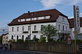
cultural heritage monument D-6-79-201-4 (0) in Unterpleichfeld, Bavaria  | |||||
| Upload media | |||||
| Instance of | |||||
|---|---|---|---|---|---|
| Location | Unterpleichfeld, Würzburg, Lower Franconia, Bavaria, Germany | ||||
| Street address |
| ||||
| Has part(s) |
| ||||
| Heritage designation | |||||
 | |||||
This is the category of the Bavarian Baudenkmal (cultural heritage monument) with the ID D-6-79-201-4 (Wikidata)
|
Deutsch: Gasthof, zweigeschossiger, verputzter Massivbau mit Halbwalmdach, am Wirtshausausleger bez. 1829. Heiligenfigur, Maria Immaculatà auf hohem Postament mit Baldachin, Sandstein, bez. 1787. Bildstock mit Marienkrönung, bez. 1748. Hauptstraße 4, Unterpleichfeld,Landkreis Würzburg, Unterfranken, Deutschland
Media in category "Hauptstraße 4, Unterpleichfeld"
The following 7 files are in this category, out of 7 total.
-
 D-6-79-201-4 Unterpleichfeld 20210626 193.jpg 5,897 × 3,923; 16.16 MB
-
 D-6-79-201-4 Unterpleichfeld 20210626 194.jpg 5,724 × 3,809; 14.35 MB
-
 Gasthof Hauptstraße 4, Unterpleichfeld 2014 1.jpg 4,928 × 3,264; 10.32 MB
-
 Gasthof Hauptstraße 4, Unterpleichfeld 2014 2.jpg 3,264 × 4,928; 8.25 MB
-
 Gasthof Hauptstraße 4, Unterpleichfeld 2014 3.jpg 3,264 × 4,928; 8.26 MB
-
 Immaculata Hauptstraße 4, Unterpleichfeld 2014 5.jpg 2,908 × 4,201; 6.22 MB
-
 Wirtshausschild Gasthof Bötsch.jpg 1,596 × 1,007; 849 KB


