Category:Haus Rotenberg 33 (Eupen)
Jump to navigation
Jump to search
| Object location | | View all coordinates using: OpenStreetMap |
|---|
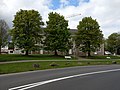
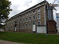
building in Eupen, Belgium  | |||||
| Upload media | |||||
| Instance of | |||||
|---|---|---|---|---|---|
| Location | Eupen, Arrondissement of Verviers, Province of Liege, Walloon Region, Belgium | ||||
| Street address |
| ||||
| Heritage designation |
| ||||
 | |||||
|
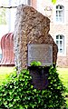
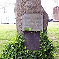
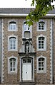
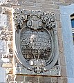
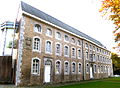
This is a category about a monument of the German-speaking Community of Belgium, number: 31149
|
Deutsch: Erbaut 1748. Teil des früheren Waisenhauses und Altenheims.
Français : Construit en 1748. Une partie de l'ancien orphelinat et maison de retraite.
Nederlands: Gebouwd in 1748. Deel van het voormalige weeshuis en verzorgingshuis.
English: Built in 1748. Part of the former orphanage and nursing home.
Media in category "Haus Rotenberg 33 (Eupen)"
The following 13 files are in this category, out of 13 total.
-
 Denkmalstein Rotenberg 33, eupen.jpg 1,133 × 1,818; 1.05 MB
-
 Denkmalstein.jpg 2,448 × 2,448; 1.93 MB
-
 Eupen Rotenberg 33 (1).jpg 4,032 × 3,024; 4.83 MB
-
 Eupen Rotenberg 33 (2).jpg 4,032 × 3,024; 4.32 MB
-
 Eupen Rotenberg 33 (3).jpg 4,032 × 3,024; 4.92 MB
-
 Eupen Rotenberg 33 (4).jpg 4,032 × 3,024; 4.53 MB
-
 Eupen Rotenberg 33 (5).jpg 1,780 × 2,239; 1.56 MB
-
 Eupen Rotenberg 33 (6).jpg 2,591 × 4,032; 5.81 MB
-
 Haus Rotenberg 33, Eupen (2).jpg 1,670 × 1,243; 997 KB
-
 Haus Rotenberg 33, Eupen (3).jpg 2,174 × 2,433; 1.52 MB
-
 Haus Rotenberg 33, Eupen (4).jpg 1,162 × 1,730; 962 KB
-
 Haus Rotenberg 33, Eupen.jpg 2,427 × 2,141; 2.62 MB
-
 Rotenberg 35 - Eupen.JPG 4,187 × 3,056; 6.2 MB


.jpg)
.jpg)
.jpg)
.jpg)
.jpg)
.jpg)
.jpg)
.jpg)
.jpg)
