Category:Heilbrunnen Heilsbronn
Jump to navigation
Jump to search
| Object location | | View all coordinates using: OpenStreetMap |
|---|
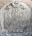
This is the category of the Bavarian Baudenkmal (cultural heritage monument) with the ID D-5-71-165-33 (Wikidata)
|
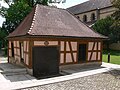
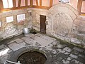
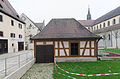
Deutsch: "Heilbrunnen" in Heilsbronn, um 1730 als Heilbad in Betrieb.
spring box of the Heilsbronn Abbey, Germany  | |||||
| Upload media | |||||
| Instance of |
| ||||
|---|---|---|---|---|---|
| Part of | |||||
| Location | Heilsbronn, Ansbach, Middle Franconia, Bavaria, Germany | ||||
| Street address |
| ||||
| Heritage designation | |||||
 | |||||
Media in category "Heilbrunnen Heilsbronn"
The following 10 files are in this category, out of 10 total.
-
 Heilsbronn Heilbrunnen 1.jpg 3,264 × 2,448; 2.37 MB
-
 Heilsbronn Heilbrunnen 2.jpg 3,264 × 2,448; 3 MB
-
 Heilsbronn Heilbrunnen innen.jpg 3,264 × 2,448; 3.79 MB
-
 Heilsbronn Heilbrunnen Inschrift.jpg 2,332 × 3,209; 10.1 MB
-
 Heilsbronn Heilbrunnen Vetus inscriptio.jpg 1,973 × 1,578; 1.23 MB
-
 Heilsbronn Heilbrunnen Wappen.jpg 1,016 × 1,153; 525 KB
-
 Heilsbronn Refektorium und Heilsbrunnen.jpg 3,264 × 2,448; 2.28 MB
-
 Heilsbronn, Münsterplatz 2, 001.jpg 4,928 × 3,264; 9.81 MB
-
 Heilsbronn, Münsterplatz 2-001.jpg 4,928 × 3,264; 8.8 MB
-
 Heilsbronn-Heilsbrunnenhaus-Innen mit Brunnenstube-24032012.JPG 2,592 × 1,944; 201 KB


