Category:Heilig Hartkerk (The Hague)
Jump to navigation
Jump to search
| Object location | | View all coordinates using: OpenStreetMap |
|---|
Nederlands: Heilig Hart van Jezuskerk - gebouwd in 1894 - afgebroken in 1974
| Address |
|
former chiuch in The Hague, The Netherland   | |||||
| Upload media | |||||
| Instance of | |||||
|---|---|---|---|---|---|
| Named after | |||||
| Made from material | |||||
| Location | The Hague, South Holland, Netherlands | ||||
| Located on street | |||||
| Architectural style | |||||
| Diocese | |||||
| Architect | |||||
| Inception |
| ||||
| Dissolved, abolished or demolished date |
| ||||
| Religion or worldview | |||||
 | |||||
Media in category "Heilig Hartkerk (The Hague)"
The following 7 files are in this category, out of 7 total.
-
 Heilig Hartkerk - 's-Gravenhage - 20085505 - RCE.jpg 1,200 × 956; 243 KB
-
 Heilig Hartkerk - 's-Gravenhage - 20085506 - RCE.jpg 1,200 × 957; 244 KB
-
 Heilig Hartkerk - 's-Gravenhage - 20085509 - RCE.jpg 1,200 × 960; 288 KB
-
 Heilig Hartkerk in afbraak - 's-Gravenhage - 20085510 - RCE.jpg 1,200 × 961; 247 KB
-
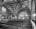 Heilig Hartkerk, interieur - 's-Gravenhage - 20085507 - RCE.jpg 1,200 × 962; 290 KB
-
 Heilig Hartkerk, interieur - 's-Gravenhage - 20085508 - RCE.jpg 1,200 × 956; 279 KB
-
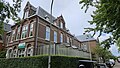 Voormalige pastorie Heilig Hartkerk, Den Haag.jpg 4,000 × 2,252; 3.81 MB


