Category:Henkes building (Rotterdam)
Jump to navigation
Jump to search
| Object location | | View all coordinates using: OpenStreetMap |
|---|
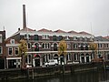
building in Rotterdam, the Netherlands  | |||||
| Upload media | |||||
| Instance of | |||||
|---|---|---|---|---|---|
| Location | Delfshaven, Rotterdam, South Holland, Netherlands | ||||
| Street address |
| ||||
| Located on street |
| ||||
| Has use |
| ||||
| Occupant |
| ||||
| Heritage designation |
| ||||
| Inception |
| ||||
 | |||||
|
This is a category about rijksmonument number 32889
|
| Address |
|
Subcategories
This category has only the following subcategory.
H
Media in category "Henkes building (Rotterdam)"
The following 8 files are in this category, out of 8 total.
-
 Delfshaven Rotterdam (the Netherlands) 08.JPG 3,240 × 4,320; 2.93 MB
-
 Delfshaven Rotterdam (the Netherlands) 10.JPG 3,240 × 4,320; 2.77 MB
-
 Delfshaven Rotterdam (the Netherlands) 11.JPG 4,320 × 3,240; 2.97 MB
-
 Delfshaven Rotterdam (the Netherlands) 12.JPG 3,240 × 4,320; 3.03 MB
-
 Delfshaven Rotterdam (the Netherlands) 39.JPG 4,320 × 3,240; 2.05 MB
-
 Henkes Delfshaven.jpg 1,200 × 1,600; 1.01 MB
-
 Rotterdam voorhaven henkes detail.jpg 2,400 × 1,712; 560 KB
-
 Rotterdam voorhaven henkes.jpg 2,613 × 1,833; 493 KB
_08.JPG)
_10.JPG)
_11.JPG)
_12.JPG)
_39.JPG)

