Category:Herenstraat 33, Amsterdam
Jump to navigation
Jump to search
| Object location | | View all coordinates using: OpenStreetMap |
|---|
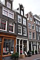
house in Amsterdam, Netherlands  | |||||
| Upload media | |||||
| Instance of | |||||
|---|---|---|---|---|---|
| Location | Amsterdam, North Holland, Netherlands | ||||
| Street address |
| ||||
| Located on street | |||||
| Heritage designation |
| ||||
 | |||||
|
This is a category about rijksmonument number 1978
|
| Address |
|
Media in category "Herenstraat 33, Amsterdam"
The following 3 files are in this category, out of 3 total.
-
 Amsterdam Herenstraat 31 - 1977.JPG 2,136 × 3,216; 3.32 MB
-
 Amsterdam Herenstraat 33 - 1978.JPG 2,136 × 3,216; 3.39 MB
-
 Cornelis Gerardus Leenheer, Afb 010118000005.jpg 2,058 × 2,602; 730 KB

