Category:Hersfelder Straße 9 (Alsfeld)
Jump to navigation
Jump to search
| Object location | | View all coordinates using: OpenStreetMap |
|---|
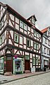
This is the category of the Hessian Kulturdenkmal (cultural monument) with the ID 13071 (Wikidata)
|
protected building in Alsfeld, Hesse, Germany   | |||||
| Upload media | |||||
| Instance of | |||||
|---|---|---|---|---|---|
| Location | Alsfeld, Vogelsbergkreis, Giessen Government Region, Hesse, Germany | ||||
| Heritage designation | |||||
 | |||||
Media in category "Hersfelder Straße 9 (Alsfeld)"
The following 10 files are in this category, out of 10 total.
-
 Alsfeld Hersfelder Strasse 9 13071.png 2,183 × 2,684; 8.13 MB
-
 Alsfeld Hersfelder Straße 11.jpg 4,000 × 6,000; 18.32 MB
-
 Alsfeld Hersfelder Straße 9.jpg 3,880 × 5,892; 16.96 MB
-
 Alsfeld, Hersfelder Straße 9, 7, Ansicht von Osten-20160504-001.jpg 4,016 × 6,016; 9.56 MB
-
 Alsfeld, Hersfelder Straße 9, Ansicht Untergasse-20160504-002.jpg 4,016 × 6,016; 10.2 MB
-
 Alsfeld, Hersfelder Straße 9-20160504-001.jpg 4,016 × 6,016; 10.38 MB
-
 Alsfeld, Hersfelder Straße 9-20160504-002.jpg 4,016 × 6,016; 11.07 MB
-
 Alsfeld, Hersfelder Straße 9-20160504-003.jpg 4,016 × 6,016; 11.96 MB
-
 Alsfeld, Hersfelder Straße 9-20160504-004.jpg 4,016 × 6,016; 11.47 MB
-
 Hersfelder Strasse 9 in Alsfeld.jpg 2,836 × 4,801; 4.75 MB


