Category:Hervormde Kerk, Marum
Jump to navigation
Jump to search
| Object location | | View all coordinates using: OpenStreetMap |
|---|
church in Marum, Groningen, the Netherlands  | |||||
| Upload media | |||||
| Instance of | |||||
|---|---|---|---|---|---|
| Location | Marum, Groningen, Netherlands | ||||
| Street address |
| ||||
| Located on street |
| ||||
| Has use | |||||
| Heritage designation |
| ||||
| Inception |
| ||||
| Significant event |
| ||||
| Religion or worldview | |||||
| official website | |||||
 | |||||
Nederlands: Hervormde kerk Marum
|
This is a category about rijksmonument number 28286
|
| Address |
|
Media in category "Hervormde Kerk, Marum"
The following 35 files are in this category, out of 35 total.
-
 Bult van Marum met Hervormde Kerk.jpg 1,632 × 918; 493 KB
-
 Detail venster noordgevel - Marum - 20151237 - RCE.jpg 1,188 × 1,200; 441 KB
-
 Detail zuid-gevel - Marum - 20151229 - RCE.jpg 1,200 × 872; 338 KB
-
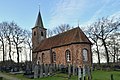
 Exterieur vanuit het oosten - Marum - 20151224 - RCE.jpg 868 × 1,200; 284 KB
-

-

-

-

-
 Exterieur vanuit het zuiden - Marum - 20151223 - RCE.jpg 897 × 1,200; 271 KB
-
 Hervormde kerk en toren..JPG 4,608 × 3,456; 1.68 MB
-
 Hervormde kerk, Marum.jpg 2,309 × 1,732; 2.65 MB
-
 Ingang Kerk...JPG 3,456 × 4,608; 1.64 MB
-
 Ingang zuidgevel - Marum - 20151241 - RCE.jpg 1,184 × 1,200; 375 KB
-
 Interieur naar het oosten - Marum - 20151233 - RCE.jpg 868 × 1,200; 139 KB
-
 Interieur naar het oosten - Marum - 20151244 - RCE.jpg 957 × 1,200; 171 KB
-
 Interieur naar het oosten - Marum - 20151245 - RCE.jpg 1,200 × 960; 179 KB
-
 Interieur naar het westen - Marum - 20151232 - RCE.jpg 1,200 × 878; 178 KB
-
 Interieur naar het westen - Marum - 20151242 - RCE.jpg 1,200 × 960; 195 KB
-
 Interieur naar het westen - Marum - 20151243 - RCE.jpg 1,190 × 1,200; 262 KB
-
 Interieur opzetstuk herenbank - Marum - 20151247 - RCE.jpg 1,179 × 1,200; 309 KB
-
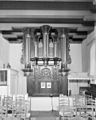 Interieur orgel - Marum - 20151246 - RCE.jpg 963 × 1,200; 199 KB
-
 Inwendig naar het oosten en naar het westen - Marum - 20151230 - RCE.jpg 1,200 × 852; 128 KB
-
 Inwendig naar het oosten en naar het westen - Marum - 20151231 - RCE.jpg 1,200 × 839; 140 KB
-
 Jacobus Stellingwerf - De kerk van Marum in Vredewold in 1672.jpg 4,728 × 3,226; 5.22 MB
-
 Marum - kerk met graven.jpg 3,949 × 5,923; 16.94 MB
-
 Marum - kerk van zuid.jpg 3,504 × 3,504; 13 MB
-
 Marum Kerk.JPG 4,000 × 3,000; 6.65 MB
-
 Marum, de Hervormde kerk RM28286 foto2 2015-05-10 15.11.jpg 4,326 × 3,245; 11.16 MB
-
 Mearum, herfoarme tsjerke.jpg 1,600 × 1,066; 1.19 MB
-
 Noordgevel - Marum - 20151235 - RCE.jpg 960 × 1,200; 387 KB
-
 Noordoostgevel - Marum - 20151236 - RCE.jpg 960 × 1,200; 299 KB
-
 Oostgevel - Marum - 20151238 - RCE.jpg 951 × 1,200; 291 KB
-
 Torenvoet zuid-westzijde - Marum - 20151234 - RCE.jpg 1,195 × 1,200; 486 KB
-
 Zuidgevel - Marum - 20151240 - RCE.jpg 948 × 1,200; 222 KB
-
 Zuidoostgevel - Marum - 20151239 - RCE.jpg 953 × 1,200; 253 KB


