Category:Hervormde kerk (Obergum)
Jump to navigation
Jump to search
| Object location | | View all coordinates using: OpenStreetMap |
|---|
church in Obergum, the Netherlands  | |||||
| Upload media | |||||
| Instance of | |||||
|---|---|---|---|---|---|
| Dedicated to | |||||
| Location | Obergum, Het Hogeland, Groningen, Netherlands | ||||
| Street address |
| ||||
| Located on street |
| ||||
| Heritage designation |
| ||||
| Inception |
| ||||
| official website | |||||
 | |||||
Nederlands: Hervormde kerk
|
This is a category about rijksmonument number 39042
|
| Address |
|
Media in category "Hervormde kerk (Obergum)"
The following 59 files are in this category, out of 59 total.
-
 Balk met inscriptie - Obergum - 20170639 - RCE.jpg 1,200 × 792; 224 KB
-
 Basement tegen noordgevel - Obergum - 20170618 - RCE.jpg 948 × 1,200; 313 KB
-
 Binnengevel noord-oost zijde - Obergum - 20170619 - RCE.jpg 1,200 × 966; 245 KB
-
 Binnengevel noord-zijde - Obergum - 20170623 - RCE.jpg 1,200 × 960; 234 KB
-
 Binnengevel zuid-zijde - Obergum - 20170624 - RCE.jpg 1,200 × 958; 230 KB
-
 Binnengevel zuid-zijde - Obergum - 20170626 - RCE.jpg 1,200 × 947; 258 KB
-
 Detail muur - Obergum - 20170608 - RCE.jpg 1,200 × 1,196; 359 KB
-
 Detail noordgevel interieur - Obergum - 20170628 - RCE.jpg 960 × 1,200; 280 KB
-
 Exterieur zuid-gevel - Obergum - 20170632 - RCE.jpg 1,200 × 955; 426 KB
-
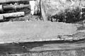
 Fundering - Obergum - 20170610 - RCE.jpg 1,200 × 1,200; 412 KB
-
 Grafkelder - Obergum - 20170620 - RCE.jpg 1,200 × 933; 283 KB
-
 Interieur - Obergum - 20170600 - RCE.jpg 1,200 × 840; 159 KB
-
 Interieur - Obergum - 20170601 - RCE.jpg 1,200 × 832; 183 KB
-
 Interieur - Obergum - 20322757 - RCE.jpg 1,200 × 781; 126 KB
-
 Interieur naar het oosten - Obergum - 20170617 - RCE.jpg 1,200 × 965; 250 KB
-
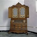 Interieur, aanzicht kabinetorgel - Obergum - 20356730 - RCE.jpg 1,200 × 1,196; 209 KB
-
 Kerk COLL.S.J.BOUMA,GR.VOOR 42 - Obergum - 20525332 - RCE.jpg 1,200 × 900; 159 KB
-
 Kerk Obergum Winsum.jpg 899 × 1,599; 127 KB
-
 Kerk vanuit het noord-oosten - Obergum - 20170596 - RCE.jpg 1,200 × 892; 255 KB
-
 Kerk vanuit het noord-westen - Obergum - 20170597 - RCE.jpg 1,200 × 828; 277 KB
-

-

-
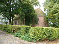
 Kerkepad - Winsum - 20215124 - RCE.jpg 1,200 × 1,200; 419 KB
-
 Kerkepad - Winsum - 20215125 - RCE.jpg 1,185 × 1,200; 365 KB
-
 Kerkepad - Winsum - 20215126 - RCE.jpg 1,193 × 1,200; 400 KB
-
 Kerkepad - Winsum - 20215138 - RCE.jpg 1,195 × 1,200; 314 KB
-
 Nikolaastsjerke, Obergum.jpg 1,600 × 1,067; 1.47 MB
-
 Nis - Obergum - 20170614 - RCE.jpg 1,200 × 1,188; 352 KB
-
 Noord-west gevel onder orgel met oude vloer - Obergum - 20170629 - RCE.jpg 1,200 × 970; 334 KB
-
 Noord-west hoek toren - Obergum - 20170605 - RCE.jpg 802 × 1,200; 212 KB
-
 Noord-west zijde - Obergum - 20170634 - RCE.jpg 1,200 × 957; 375 KB
-
 Noord-zijde bij bouwnaad schip koor - Obergum - 20170603 - RCE.jpg 802 × 1,200; 227 KB
-
 Noord-zijde exterieur - Obergum - 20170635 - RCE.jpg 798 × 1,200; 233 KB
-
 Noord-zijde interieur - Obergum - 20170627 - RCE.jpg 962 × 1,200; 230 KB
-
 Noord-zijde interieur - Obergum - 20170636 - RCE.jpg 798 × 1,200; 260 KB
-
 Obergum - kerk - schuin van achteren.jpg 6,000 × 4,000; 8.7 MB
-
 Obergumse Kerk - achterzijde.jpg 4,000 × 3,000; 4.81 MB
-
 Obergumse Kerk - voorzijde.jpg 4,000 × 3,000; 4.77 MB
-
 Oude nis - Obergum - 20170607 - RCE.jpg 1,196 × 1,200; 400 KB
-
 Oude poortje - Obergum - 20170609 - RCE.jpg 1,200 × 1,182; 350 KB
-
 Oude vloer tegen het noorden - Obergum - 20170625 - RCE.jpg 1,200 × 954; 335 KB
-
 Overzicht noordoostgevel - Obergum - 20364456 - RCE.jpg 1,200 × 956; 336 KB
-
 Overzicht vanuit het noorden - Obergum - 20322756 - RCE.jpg 1,200 × 783; 194 KB
-

-

-
 Preekstoel - Obergum - 20170602 - RCE.jpg 826 × 1,200; 190 KB
-
 Raamdetail binnen - Obergum - 20170615 - RCE.jpg 1,200 × 1,192; 272 KB
-
 Raamomlijsting - Obergum - 20170616 - RCE.jpg 1,200 × 1,197; 336 KB
-
 Toren - Obergum - 20170612 - RCE.jpg 1,200 × 1,199; 331 KB
-
 Toren oost-zijde - Obergum - 20170637 - RCE.jpg 804 × 1,200; 186 KB
-
 Torenportaal vanuit kerk - Obergum - 20170638 - RCE.jpg 805 × 1,200; 166 KB
-
 Voormalige west-gevel noord-zijde - Obergum - 20170606 - RCE.jpg 802 × 1,200; 263 KB
-
 West-gevel achter orgel - Obergum - 20170630 - RCE.jpg 1,200 × 959; 306 KB
-
 West-gevel onder orgel - Obergum - 20170622 - RCE.jpg 1,200 × 931; 230 KB
-
 Zijgevel - Obergum - 20170611 - RCE.jpg 1,200 × 1,198; 413 KB
-
 Zijgevel - Obergum - 20170613 - RCE.jpg 1,200 × 1,184; 335 KB
-
 Zuid-gevel naast orgel - Obergum - 20170621 - RCE.jpg 958 × 1,200; 220 KB
-
 Zuid-oost zijde - Obergum - 20170633 - RCE.jpg 1,200 × 959; 408 KB
-
 Zuid-zijde - Obergum - 20170631 - RCE.jpg 1,200 × 955; 441 KB


