Category:Het Groentje, Heiloo
Jump to navigation
Jump to search
| Object location | | View all coordinates using: OpenStreetMap |
|---|
|
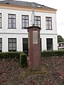
This is a category about a war memorial in the Netherlands, number: 1816
|
war memorial in Heiloo, the Netherlands  | |||||
| Upload media | |||||
| Instance of | |||||
|---|---|---|---|---|---|
| Commemorates | |||||
| Genre | |||||
| Location | Heiloo, North Holland, Netherlands | ||||
| Street address |
| ||||
| Inception |
| ||||
| Date of official opening |
| ||||
 | |||||
Media in category "Het Groentje, Heiloo"
The following 4 files are in this category, out of 4 total.
-
 Herdenkingsmonument Heiloo.JPG 480 × 640; 94 KB
-
 Het Groentje 01.jpg 1,728 × 2,548; 1.18 MB
-
 Het Groentje 02.JPG 1,920 × 2,560; 1.07 MB
-
 Het Groentje 03.JPG 1,920 × 2,560; 1.1 MB


