Category:Hindu Kush
跳转到导航
跳转到搜索
پنجابی: ھندوکش
اردو: سلسلہ کوہ ہندوکش
پښتو: هندوکش
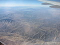
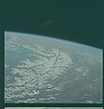
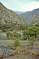
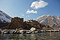
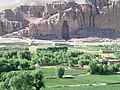
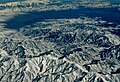
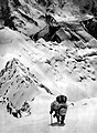
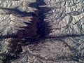
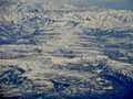
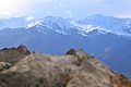
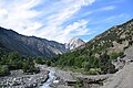
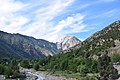
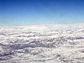
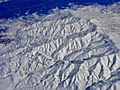
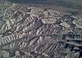
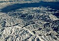
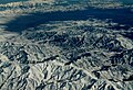
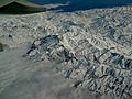
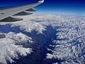
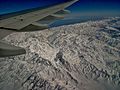
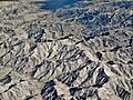
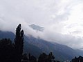
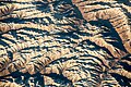
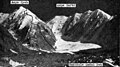
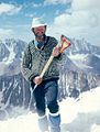
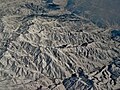
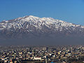
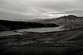
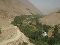
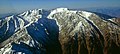
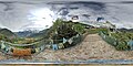
English: The Hindu Kush is a mountain range stretching 500-miles between central Afghanistan and northern Pakistan in the greater Himalayas system.
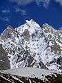
- The highest point is Tirich Mir (7,708 metres (25,289 ft)) in Khyber Pakhtunkhwa province, the former North-West Frontier Province, in Pakistan.
山脉   | |||||
| 上传媒体 | |||||
| 隶属于 | |||||
|---|---|---|---|---|---|
| 所属实体 | |||||
| 位置 |
| ||||
| 最高点 | |||||
| 海拔 |
| ||||
 | |||||
子分类
本分类有以下16个子分类,共有16个子分类。
- Maps of the Hindu Kush (20 F)
B
C
D
- Dorah Pass (7 F)
H
I
- Istor-o-Nal (3 F)
J
K
- Kafiristan (22 F)
N
- Nobaism Zom (1 F)
- Noshaq (4 F)
O
S
- Saraghrar (3 F)
T
- Tirich Mir (40 F)
分类“Hindu Kush”中的媒体文件
以下148个文件属于本分类,共148个文件。
-
 2014-08-16-15.26.58 ZS PMax Mexican Oynx-1 (14753789438).jpg 4,027 × 2,266;6.64 MB
-
 A lovely peak in Hindu Kush Range, Pakistan.jpg 4,000 × 2,664;6.56 MB
-
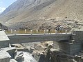
 A view from the Shah Wali Bridge's Above.jpg 1,600 × 1,200;1.09 MB
-
 A village sits in Laghman Province, Afghanistan.jpg 2,500 × 1,035;1.19 MB
-
Aerial video of Hindu Kush Range in Afghanistan.ogv 33秒, 640 × 480;5.2 MB
-
 Aerial view of Hindu Kush Range in Afghanistan.jpg 3,648 × 2,736;1.45 MB
-
 Afghanistan from above.jpg 850 × 567;157 KB
-
 Afghanistan passo del salang hindukush.jpg 800 × 546;165 KB
-
 Afghanistan's Grand Canyon.jpg 960 × 720;85 KB
-
 Apollo 9 image of the Namcha Barwa Himal range, AS09-23-3511 (22038475332).jpg 4,400 × 4,600;1.76 MB
-
 Apollo 9 image of the Namcha Barwa Himal range, AS09-23-3511.jpg 5,286 × 5,333;27.07 MB
-

-
 AS09-23-3512 (21863975079).jpg 4,400 × 4,600;1.66 MB
-

-
 Bactriane, Gandhara.jpg 1,559 × 1,272;2.04 MB
-
 Beautiful Peaks - Snowfall on Hindukush Peaks in front of Shogran Picnic Spot.jpg 4,128 × 3,096;3.42 MB
-
 BirirTal.jpg 2,089 × 3,155;1.24 MB
-
 Black Hawk flying over a valley in Bamyan.jpg 4,288 × 2,848;2.12 MB
-
 Branches of the Kunar River meet in Kunar Province.jpg 5,616 × 3,744;3.75 MB
-
 Buildings in Panjshir Province, Afghanistan.JPG 5,616 × 3,744;4.17 MB
-
 Chilam Joshi Festival in Kalash Valley.jpg 4,240 × 2,832;2.94 MB
-
 Debamjkfdev.jpg 1,500 × 1,000;245 KB
-
 Destroyed Statue, July 17, 2005 at 15-53.jpg 2,592 × 1,944;983 KB
-
 Dust Against the Hindu Kush (MODIS).jpg 4,024 × 3,415;1.62 MB
-
 File-Hindu Kush viewed from Camp Marmal at Mazar-e Sharif in Afghanistan2.JPG 2,592 × 1,944;689 KB
-
 Finnairhindukush.jpg 2,592 × 1,771;1.94 MB
-
 Flight to Mazar over Hindu Kush.jpg 708 × 531;178 KB
-
 FlugPehawarChitral.jpg 3,263 × 2,069;1.22 MB
-
 Golden Peaks (Hindu Kush Range), Pakistan.jpg 3,986 × 2,483;6.73 MB
-
 Heckel Hindu Kush 1.jpg 586 × 798;289 KB
-
 Heckel Hindu Kush 2.jpg 576 × 798;301 KB
-
 Heckel Hindu Kush 3.jpg 541 × 797;211 KB
-
 Highest peak of Hindukush.jpg 1,536 × 2,048;161 KB
-
 Hillside - panoramio (2).jpg 5,184 × 3,456;10.7 MB
-
-
 Hindu Kush and Karakoram peaks annotated (NASA satellite Terra MODIS).png 1,181 × 606;1.42 MB
-
 Hindu kush mountain range.jpg 640 × 480;227 KB
-
 Hindu Kush mountains (30357238428).jpg 3,547 × 1,973;4.51 MB
-
 Hindu Kush Mountains' view , Pakistan.jpg 4,000 × 2,664;6.1 MB
-
 Hindu Kush Mountains.JPG 4,928 × 3,264;5.11 MB
-
 Hindu Kush satellite image.jpg 5,600 × 4,400;5.01 MB
-
 Hindu Kush viewed from Camp Marmal at Mazar-e Sharif in Afghanistan.JPG 2,592 × 1,944;1.73 MB
-
 Hindu Kush.JPG 4,928 × 3,264;6.46 MB
-
 Hindukush kpk.jpg 3,264 × 2,448;1.28 MB
-
 Hindukush mountain range.jpg 4,000 × 2,666;9.53 MB
-
 Hindukush Mountains near Chitral.jpg 6,000 × 4,000;11.18 MB
-
 Hindukush Mountains Range.jpg 6,000 × 4,000;8.01 MB
-
 Hindukush Mountains.jpg 6,000 × 4,000;11.23 MB
-
 Hindukush, dark under the light!.jpg 4,608 × 2,592;2.72 MB
-
 Hindukush.JPG 2,272 × 1,704;340 KB
-
 Hindukushfinnairlaeroplanelentokone4290.jpg 2,048 × 1,232;999 KB
-

-
 Hindukushfinnairlendddtoflightlentokone.jpg 2,592 × 1,944;1.55 MB
-
 HindukushFinnairLento.jpg 1,871 × 1,422;1.11 MB
-
 Hindukushfinnairlentofinnairflightlentokone14294.jpg 1,280 × 855;581 KB
-
 Hindukushfinnairlentoflightlentokone.jpg 2,465 × 1,767;1.91 MB
-
 Hindukushfinnairlentoflightlentokoneaeroplane.jpg 2,048 × 1,536;824 KB
-
 Hindukushfinnairlentoflightlentokoneaeroplanehindukush14293.jpg 2,048 × 1,536;1,011 KB
-
 Hindukushfinnairlentoflightlentokonefinnairlentoflightdelhiindia.jpg 2,048 × 1,536;998 KB
-
 HindukushfinnairlentoflightlentokonefinnairlentoP2060004.JPG 2,560 × 1,857;2.49 MB
-
 Hindukushfinnairlentoflightlentokonehindukushfinnairlentoflightlentokone14297.jpg 2,592 × 1,944;1.72 MB
-

-
 HindukushfinnairlentoflightlentokoneP2060002.JPG 1,280 × 960;899 KB
-
 HindukushfinnairlentoflightlentokoneP2060005.JPG 2,560 × 1,920;2.4 MB
-
 HindukushfinnairlentoflightlentokoneP2060009.JPG 2,560 × 1,920;2.36 MB
-
 HindukushfinnairlentoflightlentokoneP2060011.JPG 1,280 × 960;531 KB
-
 HindukushfinnairlentoflightlentokoneP4302.jpg 1,280 × 770;658 KB
-
 Hindukushfinnairlentoflightlentokoneplanaero14288.jpg 2,512 × 1,776;1.56 MB
-
 Hindukushfinnairlight.jpg 640 × 480;223 KB
-
 Hindukushfinnairmountain.jpg 2,592 × 1,804;2 MB
-
 Hindukushfromair.jpg 1,280 × 960;396 KB
-
 HindukushfromFinnairflightfromDelhi.jpg 2,560 × 1,780;2.62 MB
-
 Hindukushhindukushairplanefinnairlentohelsinki.jpg 2,560 × 1,920;2.75 MB
-
 Hindukushindiapakistanafghanistan.jpg 1,280 × 882;785 KB
-
 Hindukushmountain14281.jpg 1,280 × 875;276 KB
-
 HINDUKUSHMOUNTAINRANGE.jpg 2,592 × 1,944;1.8 MB
-
 Hindukushpakistan000058.jpg 2,048 × 1,536;1.16 MB
-
 Hindukushpakistanindiaafganistan.jpg 1,280 × 960;710 KB
-
 Hindukushpakistanindiaafganistan000057.jpg 2,048 × 1,536;1.04 MB
-
 Hindukushpakistanindiaflightfinnair.jpg 2,560 × 1,920;1.97 MB
-
 Hindukushplanewing.jpg 2,048 × 1,536;1.12 MB
-
 Hindukushvuoristointiapakistanafganistan.jpg 1,280 × 960;767 KB
-
 Hindukushvuoristopakistanafganistanindia.jpg 1,280 × 929;797 KB
-
 Hinukush Mountains.jpg 6,000 × 4,000;11.36 MB
-
 HKH-Glacier-Mass-Change.png 998 × 796;1.52 MB
-
 Img1-dasu.JPG 5,184 × 3,456;5.8 MB
-
 Jamrūd Fort near the Khyber WDL11467.png 1,240 × 1,024;1.64 MB
-
 Jamrūd Fort, Another View WDL11468.png 1,237 × 1,024;1.64 MB
-
 Kalam, Swat,Pakistan 03.jpg 2,048 × 1,536;309 KB
-
 Kanjut River near Chalt in E.F. Knight's book.jpg 606 × 462;65 KB
-
 Kanjut Valley near Passu in E.F. Knight's book.jpg 558 × 420;66 KB
-
 Karakorum (Satellite picture) - 2.jpg 5,568 × 3,712;2.94 MB
-
 Karakorum (Satellite picture).jpg 5,568 × 3,712;2.89 MB
-
 Kazimierz Piotrowski Aspe Syah 1971.jpg 1,164 × 649;401 KB
-
 Ivan Kluvánek - hindukush 1974.jpg 774 × 1,024;120 KB
-
 Kuran wa Munjan valley, looking to the south.png 1,200 × 900;1.77 MB
-
 KUSHHINDUMOUNTAINPAKISTAN.jpg 1,858 × 1,392;1.24 MB
-
 Lake Band-e-Amir.jpg 1,024 × 768;536 KB
-
 Landscape in Paktia Province.jpg 4,288 × 2,848;594 KB
-
 Lataband Road 1.jpg 2,580 × 1,800;601 KB
-
 Lataband Road 2.jpg 2,128 × 2,832;846 KB
-
 Lataband Road hut.jpg 2,832 × 2,128;884 KB
-
 Lataband Road mountains.jpg 2,832 × 2,128;886 KB
-
 Malamjabba,.jpg 4,032 × 3,024;4.31 MB
-
 Manich.jpg 1,024 × 768;490 KB
-
 Mankial Mountains.jpg 3,000 × 4,000;8.4 MB
-
 Mankiyal Peaks Pakistan.jpg 3,000 × 4,000;8.39 MB
-
 Mountains in Afghanistan.JPG 4,288 × 2,848;2.45 MB
-
 Mountains of Afghanistan.jpg 3,072 × 2,304;2.39 MB
-
 Mountains of Kabul.jpg 1,024 × 768;468 KB
-
 Mountains of the Chitral Valley.jpg 4,638 × 3,072;3.18 MB
-
 Mountains of the Hindu Kush.JPG 4,928 × 1,732;6.44 MB
-
 Naghloo Reservoir (4400225393).jpg 1,024 × 681;308 KB
-
 Naw shakh.jpg 1,024 × 451;104 KB
-
 NE from Kotal Putsigram 1969 - panoramio.jpg 668 × 444;94 KB
-
 Pajuk Road,.jpg 3,072 × 2,304;3.1 MB
-
 Panjshir promotes tourism development.jpg 2,568 × 1,848;503 KB
-
 PkHindukuschFlug2.jpg 3,271 × 1,478;995 KB
-
 Rakaposhi View from Babusar Top.jpg 2,048 × 1,152;367 KB
-
 River in Badakhshan province of Afghanistan.jpg 1,024 × 768;200 KB
-
 Road Tai-Siwai Jer-Ali - panoramio.jpg 3,648 × 2,736;3.59 MB
-
 Shah Wali Bridge.jpg 1,600 × 1,200;1.08 MB
-
 Shah wali's Bridge south view.jpg 1,600 × 1,200;1.04 MB
-
 Shrine - Ali Baba001 copy.jpg 2,083 × 1,495;751 KB
-
 Snow in Hindu Kush (MODIS 2021-03-02).jpg 3,101 × 2,670;1.27 MB
-

-

-
 Storm clouds at Bagram Air Field, Afghanistan.jpg 2,500 × 1,329;885 KB
-
 Stream in Nuristan province.jpg 4,288 × 2,848;1.09 MB
-
 T-62 tank abandoned in Afghanistan.jpg 1,280 × 847;161 KB
-
 Thanda Jungle - Boyun Village Kalam.jpg 4,608 × 3,456;8.95 MB
-
 The Hindu kush (21218251763).jpg 4,496 × 2,412;2.51 MB
-
 The junction of three mighty mountain ranges (Himalayas-Hindu Kush-Karakoram).jpg 4,160 × 2,340;3.76 MB
-
 Tirich Mir Hotel.jpg 1,476 × 874;683 KB
-
 View of Hindu Kush.jpg 2,592 × 1,952;682 KB
-
 Warsaj Nature Green Places.jpg 1,600 × 1,200;1,007 KB
-
 Warsaj Nature, a little upper of the weghnan pool.jpg 1,600 × 1,200;1.18 MB
-
 Warsaj Nature, good places of warsaj.jpg 1,600 × 1,200;1.12 MB
-
 Warsaj Nature, River of Miyan Shahr.jpg 1,600 × 1,200;1.14 MB
-
 Warsaj Nature.jpg 1,600 × 1,200;1.27 MB
-
 Warsaj's mountain view.jpg 1,600 × 1,200;865 KB
-
 Warsaj's river view.jpg 1,600 × 1,200;1.1 MB
-
 Waygale Valley - panoramio.jpg 5,184 × 3,456;8.9 MB
-
 Where Three Ranges Meet.jpg 5,184 × 3,456;22.15 MB
-
 Wind farm in Panjshir Province-2.jpg 3,264 × 2,448;1.79 MB
-
 WP 000053.jpg 2,048 × 1,536;1.18 MB
-
 حوض وغنان.jpg 3,072 × 2,304;2.41 MB
-
 南迦巴瓦峰,是中国西藏林芝地区最高的山,海拔7782米,高度排在世界最高峰行列的第16位.jpg 6,000 × 3,000;9.28 MB
.jpg)


.jpg)


.jpg)


.jpg)


,_Pakistan.jpg)


.jpg)

.png)

.jpg)


_-_2.jpg)
.jpg)


.jpg)


.jpg)


.jpg)
.jpg)


