Category:Hoek 47, Dussen
Jump to navigation
Jump to search
| Object location | | View all coordinates using: OpenStreetMap |
|---|
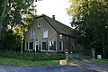
farmhouse in Werkendam, Netherlands  | |||||
| Upload media | |||||
| Instance of | |||||
|---|---|---|---|---|---|
| Location | Dussen, Werkendam | ||||
| Street address |
| ||||
| Located on street |
| ||||
| Heritage designation |
| ||||
 | |||||
|
This is a category about rijksmonument number 14206
|
| Address |
|
Media in category "Hoek 47, Dussen"
The following 2 files are in this category, out of 2 total.
-
 Aanzicht - Dussen - 20065425 - RCE.jpg 1,200 × 802; 199 KB
-
 Dussen - Boerderij - Hoek 47.jpg 800 × 534; 355 KB
