Category:Hogewoerd 32, Leiden
Jump to navigation
Jump to search
| Object location | | View all coordinates using: OpenStreetMap |
|---|
house in Leiden, Netherlands  | |||||
| Upload media | |||||
| Instance of | |||||
|---|---|---|---|---|---|
| Location | Leiden, South Holland, Netherlands | ||||
| Heritage designation |
| ||||
 | |||||
|
This is a category about rijksmonument number 24856
|
| Address |
|
Media in category "Hogewoerd 32, Leiden"
The following 8 files are in this category, out of 8 total.
-
 Achtergevel - Leiden - 20136102 - RCE.jpg 800 × 1,200; 157 KB
-
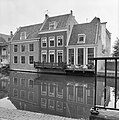 Achtergevels - Leiden - 20136100 - RCE.jpg 1,192 × 1,200; 288 KB
-
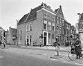
 Hoek Hooigracht - Leiden - 20136088 - RCE.jpg 1,200 × 944; 255 KB
-
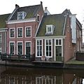
 Leiden - Hogewoerd 32 Dio.jpg 2,700 × 2,700; 1.26 MB
-
 Leiden - Hogewoerd 32.JPG 3,056 × 4,592; 4.08 MB
-
 Leiden - Watersteeg 1-3 Dio.jpg 2,900 × 2,900; 1.11 MB
-
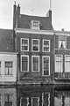
 Voorgevel - Leiden - 20136097 - RCE.jpg 1,200 × 960; 272 KB
-
 Voorgevel - Leiden - 20136101 - RCE.jpg 948 × 1,200; 256 KB


