Category:Hoofdstraat 137, Beerta
Jump to navigation
Jump to search
| Object location | | View all coordinates using: OpenStreetMap |
|---|
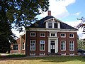
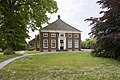
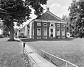
farmhouse in Oldambt, Netherlands  | |||||
| Upload media | |||||
| Instance of | |||||
|---|---|---|---|---|---|
| Location | Beerta, Oldambt, Groningen, Netherlands | ||||
| Street address |
| ||||
| Located on street |
| ||||
| Heritage designation |
| ||||
 | |||||
|
This is a category about rijksmonument number 8865
|
| Address |
|
Media in category "Hoofdstraat 137, Beerta"
The following 15 files are in this category, out of 15 total.
-
 Aanzicht - Beerta - 20029665 - RCE.jpg 1,200 × 807; 277 KB
-
 Achtergevel - Beerta - 20029669 - RCE.jpg 1,200 × 950; 283 KB
-
 Oldambster boerderij met voorgevel geleed door middenrisaliet en vier pilasters Beerta 1.jpg 3,648 × 2,736; 2.25 MB
-
 Oldambster boerderij met voorgevel geleed door middenrisaliet en vier pilasters Beerta 2.jpg 3,648 × 2,736; 2.33 MB
-
 Oldambster boerderij met voorgevel geleed door middenrisaliet en vier pilasters Beerta 3.jpg 3,648 × 2,736; 2.52 MB
-
 Overzicht van de achtergevel, de schuur - Beerta - 20421402 - RCE.jpg 1,200 × 800; 223 KB
-
 Overzicht van de voorgevel - Beerta - 20421392 - RCE.jpg 1,200 × 800; 186 KB
-
 Overzicht van de voorgevel en westgevel - Beerta - 20421395 - RCE.jpg 1,200 × 800; 243 KB
-
 Overzicht van de voorgevel met gazon - Beerta - 20421393 - RCE.jpg 1,200 × 800; 266 KB
-
 Overzicht van de westevel - Beerta - 20421397 - RCE.jpg 1,200 × 800; 261 KB
-
 Overzicht van de westevel met gazon - Beerta - 20421399 - RCE.jpg 1,200 × 800; 293 KB
-
 Overzicht van de westevel met tuin - Beerta - 20421401 - RCE.jpg 1,200 × 800; 314 KB
-
 Voor- en L.zijgevel - Beerta - 20029667 - RCE.jpg 1,200 × 954; 335 KB
-
 Voor- en L.zijgevel - Beerta - 20029668 - RCE.jpg 1,200 × 950; 317 KB
-
 Voorgevel - Beerta - 20029666 - RCE.jpg 1,200 × 960; 338 KB


