Category:Hoofdstraat 1 (Blije)
Jump to navigation
Jump to search
| Object location | | View all coordinates using: OpenStreetMap |
|---|
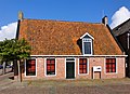
building in Ferwerderadiel, Netherlands  | |||||
| Upload media | |||||
| Instance of | |||||
|---|---|---|---|---|---|
| Location | Blije, Noardeast-Fryslân, Friesland, Netherlands | ||||
| Located on street |
| ||||
| Heritage designation |
| ||||
 | |||||
|
This is a category about rijksmonument number 15589
|
| Address |
|
Media in category "Hoofdstraat 1 (Blije)"
The following 2 files are in this category, out of 2 total.
-
 Hoek Hoofdstraat - Blija - 20035678 - RCE.jpg 1,200 × 809; 227 KB
-
 Hoofdstraat1 Blija.jpg 1,686 × 1,218; 576 KB
