Category:Hoofdstraat 23, Niekerk
Jump to navigation
Jump to search
| Object location | | View all coordinates using: OpenStreetMap |
|---|
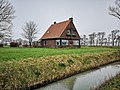
house in De Marne, Netherlands  | |||||
| Upload media | |||||
| Instance of | |||||
|---|---|---|---|---|---|
| Part of | |||||
| Location | Niekerk, Het Hogeland, Groningen, Netherlands | ||||
| Street address |
| ||||
| Located on street |
| ||||
| Heritage designation |
| ||||
 | |||||
|
This is a category about rijksmonument number 509481
|
| Address |
|
Media in category "Hoofdstraat 23, Niekerk"
The following 6 files are in this category, out of 6 total.
-
 Niekerk - Hoofdstraat 23 (1).jpg 3,648 × 2,736; 4.21 MB
-
 Niekerk - Hoofdstraat 23 (2).jpg 3,648 × 2,736; 3.91 MB
-
 Niekerk - Hoofdstraat 23 (3).jpg 3,648 × 2,736; 3.8 MB
-
 Tuinderij Niekerk1.jpg 3,648 × 2,736; 1.3 MB
-
 Tuinderij Niekerk2.jpg 3,577 × 2,683; 1.85 MB
-
 Tuinderij Niekerk3.jpg 2,736 × 3,648; 1.6 MB
.jpg)
.jpg)
.jpg)

