Category:Hoofdstraat 35, Leens
Jump to navigation
Jump to search
| Object location | | View all coordinates using: OpenStreetMap |
|---|
 | |||||
| Upload media | |||||
| Instance of | |||||
|---|---|---|---|---|---|
| Location | Leens, Leens | ||||
| Street address |
| ||||
| Located on street |
| ||||
| Heritage designation |
| ||||
| Inception |
| ||||
 | |||||
Nederlands: Villa Oosterhouw
|
This is a category about rijksmonument number 509504
|
| Address |
|
Media in category "Hoofdstraat 35, Leens"
The following 9 files are in this category, out of 9 total.
-
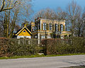
 Hoofdstraat 35 Leens.jpg 1,770 × 1,327; 796 KB
-
 Oosterhouw (zijaanzicht).jpg 4,080 × 3,264; 15.09 MB
-
 Overzicht achtergevel met vijver op de voorgrond - Leens - 20364563 - RCE.jpg 1,200 × 956; 346 KB
-
 Overzicht rechter zijgevel met gevelbeelden - Leens - 20364559 - RCE.jpg 1,200 × 949; 313 KB
-
 Overzicht voorgevel - Leens - 20364565 - RCE.jpg 1,200 × 954; 353 KB
-
 Slaapkamer Oosterhouw - juli 2020.jpg 4,032 × 3,024; 1.96 MB
-
 Tuin Oosterhouw - haag - juli 2020.jpg 3,024 × 4,032; 5.53 MB
-
 Tuin Oosterhouw - overzicht - juli 2020.jpg 4,032 × 3,024; 5.6 MB
-
 Tuin Oosterhouw - zicht op Oosterhouw - juli 2020.jpg 3,024 × 4,032; 4.09 MB
.jpg)


